
Charing Cross Road is a street in central London running immediately north of St Martin-in-the-Fields to St Giles Circus, which then merges into Tottenham Court Road. It leads from the north in the direction of Charing Cross at the south side of Trafalgar Square. It connects via St Martin's Place and the motorised east side of the square.

Bloomsbury is a district in the West End of London, England. It is considered a fashionable residential area, and is the location of numerous cultural, intellectual, and educational institutions.

Tottenham Court Road is a major road in Central London, almost entirely within the London Borough of Camden.

St Giles Circus is a road junction in the St Giles district of the West End of London at the eastern end of Oxford Street, where it connects with New Oxford Street, Charing Cross Road and Tottenham Court Road, which it is more often referred to owing to the location of Tottenham Court Road Underground station directly under the junction. It is near to Soho, Covent Garden, Bloomsbury and Fitzrovia.
Malet Street is a street in Bloomsbury, in the London Borough of Camden, Central London, England. It runs between Torrington Place and the British Museum, parallel to Gower Street and Tottenham Court Road.
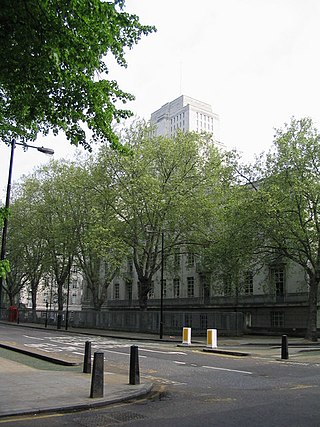
Gower Street is a two-way street in Bloomsbury, central London, running from Euston Road at the north to Montague Place in the south. The street is continued from North Gower Street north of Euston Road. To the south, it becomes Bloomsbury Street.

Dillons was a British bookseller founded in 1936, named after its founder and owner Una Dillon. Originally based in Bloomsbury in London, the company expanded under subsequent owners Pentos in the 1980s into a bookselling chain across the United Kingdom. In 1995 Pentos went into receivership and sold Dillons to Thorn EMI, which immediately closed 40 of the 140 Dillons bookstore locations. Of the remaining 100 stores, most kept the name Dillons, while the remainder were Hatchards and Hodges Figgis. Within Thorn EMI, Dillons was placed in the HMV Group, which had been a division of Thorn EMI since 1986. EMI demerged from Thorn in August 1996, and Dillons-HMV remained an EMI holding. Dillons was subsumed under rival chain Waterstones' branding in 1999, at which point the brand ceased to exist.

Tottenham High Road is the main thoroughfare through the district of Tottenham, in the London Borough of Haringey. It runs from Edmonton in the North to Stamford Hill in the South. South of Bruce Grove the road is part of the A10; to the north it is part of the A1010. Tottenham High Road passes through the London postcode areas of N17 and N15 and is 2.3 miles in length.

The New Road was a toll road built across fields around the northern boundaries of London, the first part of which opened in 1756. The route comprises the modern-day A501.

The Bedford Estate is an estate in central London owned by the Russell family, which holds the peerage title of Duke of Bedford. The estate was originally based in Covent Garden, then stretched to include Bloomsbury in 1669. The Covent Garden property was sold for £2 million in 1913 by Herbrand Russell, 11th Duke of Bedford, to the MP and land speculator Harry Mallaby-Deeley, who sold his option to the Beecham family for £250,000; the sale was finalised in 1918.
Rathbone Street is a street in London that runs between Charlotte Street in the north and the junction of Rathbone Place and Percy Street in the south. The street is partly in the London Borough of Camden and partly in the City of Westminster.

The Duke of York is a public house at 47 Rathbone Street, Fitzrovia, London, W1. It is located in the north of the street on the corner with Charlotte Place and bears the year 1791.

Chenies Street is a street in Bloomsbury, London, that runs between Tottenham Court Road and Gower Street. It is the location of a number of notable buildings such as Minerva House, the Drill Hall, and a memorial to The Rangers, 12th County of London Regiment. North Crescent starts and ends on the northern side of Chenies Street.

The American International Church, currently located at the Whitefield Memorial Church on Tottenham Court Road in London, was established to cater for American expatriates resident in London. Organised in the American denominational tradition, the church was originally named the American Church in London but changed its name in 2013 to reflect that it caters to approximately 30 different nationalities.
Huntley Street is a street in Bloomsbury, London, known for its close association with University College Hospital.

Ridgmount Gardens is a street in Bloomsbury, London, that runs from Torrington Place in the north to Chenies Street in the south. It runs parallel with Huntley Street and Gower Street and is continued by Ridgmount Place in the south.

Store Street is a street in Bloomsbury, London.

Whitfield Street is a street in the London Borough of Camden that runs from Warren Street in the north to Windmill Street in the south. The street is crossed by Grafton Way, Maple Street, Howland Street, Wayland Street, and Goodge Street. Whitfield Place starts and ends in Whitfield Street on its eastern side. Hertford Place, Chitty Street and Scala Street all join Whitfield Street on its western side.

Chitty Street is a street in the London Borough of Camden that runs between Charlotte Street and Whitfield Street. Charlotte Mews adjoins Chitty Street on its south side.

Keppel Street is a street in the London Borough of Camden that runs from the junction of Store Street and Gower Street in the west to Malet Street in the east. Before the construction of Senate House, it continued on to join Russell Square.
