The Pir Panjal Range is a range of mountains in the Lower Himalayan region located in the Western Himalayas of northern Indian subcontinent. It runs southeast to northwest between the Beas and Neelam/Kishanganga rivers, in the Indian state of Himachal Pradesh and Indian-administered union territory of Jammu and Kashmir, with its northwestern end extending into territory administered by Pakistan. The Himalayas show a gradual elevation towards the Dhauladhar and Pir Panjal ranges. Pir Panjal is the largest and westernmost range of the Lesser Himalayas. Near the bank of the Sutlej River, it dissociates itself from the main Himalayan range and forms a divide between the Beas and Ravi rivers on one side and the Chenab on the other. Further west, the Pir Panjal range forms the southwestern boundary of the Kashmir Valley, separating it from the hills of Jammu region, forming a divide between the Jhelum and Chenab rivers.

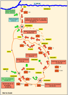
Poonch or Punch is a district of the Jammu division of Indian-administered Jammu and Kashmir in the disputed Kashmir region. With headquarters in the town of Poonch, it is bounded by the Line of Control on three sides. The 1947–48 war between India and Pakistan divided the earlier district into two parts. One went to Pakistan and the other became part of the then-Indian state of Jammu and Kashmir.

Shopian, known as Shupyan in Kashmiri, is an administrative division of the Shopian district. It is located in southern part of Kashmir Valley, of Jammu and Kashmir, India. Shopian is called the ''Apple town of Kashmir'' as majority of the population engages in apple growing practices. It also provides employment to more than 60% of the population. It is 2nd richest district in Kashmir region after Srinagar.

Poonch, is a town and the administrative headquarters of the Poonch district, of the Indian-administered union territory of Jammu and Kashmir, which is part of the larger disputed territory of Kashmir. It is located near the Line of Control – the de facto border in the disputed region. Poonch shares a de facto border with the Poonch district of the Pakistan-administered, self-governing territory of Azad Kashmir.

Beerwah also pronounced as Beeru is a subdistrict, tourist destination and one of the oldest towns of Jammu and Kashmir and a municipal committee in Budgam district in the Indian administered union territory of Jammu and Kashmir. It is also one of the oldest tehsils of Jammu and Kashmir with one of the largest towns in Budgam district. Beerwah is 27 km (17 mi) away from the summer capital Srinagar via Bemina, 31 km (19 mi) via Magam, 33 km (21 mi) via Soibugh and 35 km (22 mi) via Budgam. Beerwah subdistrict has 4 tehsils namely Beerwah, Magam, Narbal and Khag. Beerwah is located along the banks of River Sukhnaag.

Poonch District was a district of the princely state of Jammu and Kashmir, which is currently divided between India and Pakistan. The Pakistani part of the erstwhile district is now the Poonch Division in the Azad Kashmir territory, whilst the Indian part of the district is the Poonch district in Jammu and Kashmir. The capital of the Pakistan-controlled side is Rawalakot; while the capital of the Indian-controlled side is Poonch.

Mughal Road is the road between Bufliaz, a town in the Poonch district, to the Shopian district, in the union territory of Jammu and Kashmir, India. The 84-kilometre road traces a historic route used in the Mughal period over the Pir Panjal Pass, at an altitude of 3,500 m (11,500 ft), higher than the Banihal pass at 2,832 m (9,291 ft).
The Battle of Shopian took place on 3 July 1819 between an expeditionary force from the Sikh Empire and Jabbar Khan, the governor of the Kashmir Valley province of the Durrani Empire. It was the decisive battle during the Sikh expedition into Kashmir in 1819.
Surankote is a town in the Surankote Tehsil of the Poonch district of the Indian union territory of Jammu and Kashmir. It occupies the Surankote valley, located between the Pir Panjal and ranges within the Himalayas. It receives snowfall in winters. It is famous for the existence of lakes on the Pir Panjal range which are not still connected with the outside world. Although some people visit these lakes by foot for recreation and refreshment.

Rathsun or Rathsoon is a village and block located in the Jammu and Kashmir's Budgam district. It is situated at the base of the Pir Panjal Range of the Himalayas. It falls under the administrative division of tehsil Beerwah one of the nine tehsils of district Budgam. It is about 23.7 kilometres (14.7 mi) via Beerwah-Budgam Road from district headquarters Budgam, 7 km (4.3 mi) from Beerwah, Jammu and Kashmir, it is situated 29 km (18 mi) away from Srinagar, the summer capital of Jammu and Kashmir. Magam, is nearest town to Rathsun .The shrine of Sufi saint Baba Hanifudin Reshi is on a hill of this village.
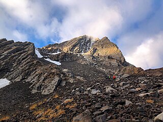
Tratte Koot or Tatakooti or Tatakuti, Peak is a mountain with a peak elevation of 4,760 metres (15,620 ft), on the border of Budgam and Poonch districts of Jammu and Kashmir, India. The most conspicuous and imposing peak of Pir Panjal range is undoubtedly Tatakooti. The other higher peak of this range is Sunset Peak at 4,750 m. Tatakooti, along with Sunset Peak, lies south west of the Kashmir valley. It is located 40 km west of Shopian town and 30 km from Chadoora Budgam and 105 km southwest of Srinagar, the summer capital of Jammu and Kashmir. It is the highest peak of the Pir Panjal bounding Kashmir from SW.

Yusmarg or Yousmarg is a hill station in the western part of the Budgam district of Jammu and Kashmir, India. It is situated 53 km (33 mi) south of Srinagar, the summer capital of the state. Yousmarg provides space for beautiful landscapes, young pine nurseries, green pastures and heart touching lotic and lentic water bodies. Nilnag, Doodhganga and a nascently created artificial dam adds more to the beauty of the meadows. Nature has bestowed Yusmarg with pleasant flora and fauna. Yusmarg is often referred to as a trekkers paradise.Yusmarg has some modest stay options but some new homestays have come up around the area.Tribe homestay and cafè located at the nearest village Nagbal is gaining popularity especially among the youth. The place is rustic, wooden and reflects the Kashmiri architectural heritage. Among fauna, locals claim that they often sight wolves, bears, apes, cats, aves of various types. Among aquatic fauna, schizothoraxic is abundant one in catch.

Khag is a tehsil in and block in the Beerwah sub-district of the Budgam district in the Indian union territory of Jammu and Kashmir. It is 8.8 km (5.5 mi) away from sub-district headquarter Beerwah and 35 km (22 mi) away from Srinagar, the summer capital of Jammu and Kashmir.

Doodhpathri is a tourist destination and a hill station located in the Khansahib tehsil of the Budgam district of Jammu and Kashmir, India. Situated at an altitude of 2,730 metres (8,960 ft) from sea level, it is located at a distance of 42 km (26 mi) from Jammu and Kashmir's summer capital, Srinagar, and 30 km (19 mi) from its district headquarters, Budgam.

The Pir Panjal Pass, also called Peer Ki Gali, is a mountain pass and a tourist destination located in the Pir Panjal Range in Jammu and Kashmir, India. It connects the Kashmir Valley to the Rajouri and Poonch districts of Jammu via the Mughal Road. It is the highest point on the Mughal road at 3,490 m (11,450 ft) and lies to the southwest of the Kashmir valley.

Noori Chamb is a waterfall in the headwaters of the Poonch River in Poonch district of Jammu and Kashmir in India. It is named after the Mughal queen Nur Jahan.
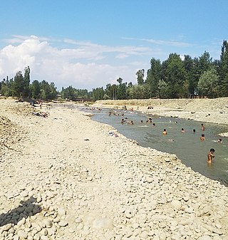
The Sukhnag River is one of the major tributaries of the River Jhelum located in Budgam District in the Kashmir Valley in the union territory of Jammu and Kashmir, India. It originates in the Tosa Maidan locale of Pir Panjal Range and has a length of 54 km (34 mi).

Arizal is a village in Budgam district in Kashmir region of Indian Union Territory Jammu and Kashmir. It is situated at the base of the Pir Panjal Range of the Himalayas, in the Sukhnag Valley. It falls under the administrative division of tehsil Khansahib, which is one of the nine tehsils of district Budgam. It lies at a distance of about 35 kilometres (22 mi) from the district headquarters Budgam, 16 kilometres (9.9 mi) from the sub-district headquarters Khansahib, and 45 kilometres (28 mi) away from Srinagar, the summer capital of Jammu and Kashmir.

The Pir Panjal Region is a region located in the southwestern part of the Pir Panjal Range in the Jammu Division of the Indian-administered union territory of Jammu and Kashmir. This name particularly refers to the districts of Poonch and Rajouri.
The Kashmir expedition took place in 1814 after the battle of Attock. Ranjit Singh began planning to invade Kashmir, leading to the Sikh invasion led by Hari Singh Nalwa and Ram Dayal.