Tourism in Venezuela

Last updated
El Agua Beach (Margarita Island) Playa El Agua.JPG
El Agua Beach (Margarita Island)
Morrocoy National Park Cocotero en Cayo Sombrero.jpg
Morrocoy National Park
Choroni Beach, Choroni Beach choroni venezuela.jpg
Choroní Beach, Choroní
Angel falls SaltoAngel1.jpg
Ángel falls
Chinak-Meru (Canaima National Park) Chinak-Meru (Aponguao).jpg
Chinak-Meru (Canaima National Park)
Caroni River (La Llovizna National Park) Parque La Llovizna.jpg
Caroní River (La Llovizna National Park)
Livestock culture in Apure State (Los Llanos Region) Ganaderia en los Llanos.jpg
Livestock culture in Apure State (Los Llanos Region)
Scarlet Ibis in Los Llanos Region CorocorasLlanos.jpg
Scarlet Ibis in Los Llanos Region
Bolivar Peak during snow season Pico Bolivar al desnudo en dia soleado y despejado.jpg
Bolívar Peak during snow season
Medanos de Coro (Coro's dunes) Medanos- Coro.jpg
Médanos de Coro (Coro's dunes)
German origin settlement town Colonia Tovar Iglesia San Martin de Tours 2.jpg
German origin settlement town Colonia Tovar
Example of a church in Coro Colonial city Iglesia en Coro.JPG
Example of a church in Coro Colonial city
Colonial houses (city of Maracaibo) Calle Carabobo en el Saladillo de Maracaibo 18.JPG
Colonial houses (city of Maracaibo)
Cuquenan Falls is the second tallest major waterfall in Venezuela after Angel Falls. SaltoKukenan.jpg
Cuquenan Falls is the second tallest major waterfall in Venezuela after Angel Falls.

Tourism in Venezuela has been developed considerably for decades, particularly because of its geographical position, the variety of landscapes, the richness of plants and wildlife, the artistic expressions and the privileged tropical climate of the country, which affords each region (especially the beaches) throughout the year. Since 2013[ citation needed ], the country is having a very severe economic and political crisis affecting tourism all over the country. [2]

Contents

Major destinations

Mérida

Mérida state is a major tourist center in Venezuela. It has an extensive network of hotels not only in the capital city but also throughout the state. Starting from the city of Mérida, it has the longest and highest cable car in the world, reaching the Espejo Peak of 4,765 m (15,633 ft). In the Méridan páramos, there are good hotels and restaurants. Another place to visit is Mucuchíes, the village of Los Aleros. There is also the National Observatory of Llano del Hato. The city has several museums worth visiting: Beekeeping Museum, Colonial Art Museum, Modern Art Museum, and the Museum of the great Méridan Don Mariano Picón Salas and the Aquarium Garden. Also in the state are hot springs such as Bailadores Las Tapias and la Capellanía Park.

Margarita Island

Margarita is an island with modern infrastructure, bordered by beaches suitable for extreme sports, and features castles, fortresses and churches of great cultural value. This island is found in the Caribbean Sea and is well known for its pearls. [3]

Caracas

Caracas is the capital of Venezuela and a world-class cosmopolitan city. In the west of the city, the Libertador municipality, tourism is important in regard to the historic center of the city, the Caracas Cable Car (Ávila mountain Cable Car), the University City of Caracas, Zoos, Sabana Grande Boulevard, among others.

In the east of the city, especially in the Chacao and Baruta municipalities environment of progress and modernism is indisputable, European-style shopping malls, beautiful squares, night clubs, etc. Also the Generalísimo Francisco de Miranda Park, located in the Sucre municipality is heavily of exploitation for tourism.

In the southeast end of city is located a small town, El Hatillo, which has an impeccable colonial town, an atmosphere of peace and tranquility.

To further exploitation of tourism as a factor of endogenous development, the national government has created socio-cultural plans of international concern as the Feria Internacional de Turismo de Caracas (FITCAR), which has been carried held annually since 2005 and promotes tourism in the country, showing to the world the cultural, tourist, traditional, musical and culinary wonders of Venezuela.

Venezuela has some of the most dangerous cities in the world, [4] for example in 2018, there were 2,980 murders in Caracas (99.98 per 100,000 inhabitants), [5] 645 murders in Ciudad Guayana (78.30 per 100,000 inhabitants), [5] and 264 murders in Ciudad Bolívar (69.09 per 100,000 inhabitants). [5] In Venezuela, under two per cent of reported crimes are prosecuted. [6]

Los Roques and Morrocoy

The archipelago of Los Roques is formed by a group of islands and cays that make up one of the main tourist attractions of the country. With exotic pristine beaches. Morrocoy is a park, consisting of very small nearby islands to the mainland, which have grown rapidly as one of the biggest tourist attractions in the Caribbean.

Canaima

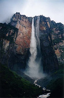
Canaima National Park is spread over 30,000 square kilometres (12,000 sq mi) to the border with neighbouring Guyana and Brazil, for its size is considered the world's sixth largest national park. About 65% of the park is occupied by rock plateaus called tepuis. These are a unique biological environment, also presenting a great geological interest. Its steep cliffs and waterfalls (including Angel Falls, which is the highest waterfall of the world, 1,002 m (3,287 ft)) are spectacular sceneries.

World Heritage

Other tourist destinations

Beaches

Venezuela has many beaches of calm waters and for extreme sports. Besides those already mentioned, the sites most famous for its beauty are:

Jungle and Savannah

South of Venezuela in the states Bolivar, Amazonas and Delta Amacuro begins the Amazon rainforest, the largest rainforest and the largest nature reserve in the world. This area of the country has great touristic value, because there is the Angel Falls, the highest waterfall of the world; savannah, rivers, forests and tepuis form a ecotourism that has not yet been truly exploited, it is necessary that the national government to promote plans to turn over this Venezuelan soil an essential point for ecotourism in this part of the world.

However, the influx of international tourists in Canaima and the Gran Sabana is high and has been gradually growing, some attractions in forest and savanna in Venezuela are:

Mountain

Although Venezuela is dominated by plains and tropical temperatures, with the Andes which are beginning in Venezuela it has also a mountain range of great tourist attraction. Mérida state consists mainly of páramo vegetation, low temperatures, snow filled peaks, glaciers and high mountains of the Venezuelan Andes. Some of the Venezuelan mountain attractions are:

Los Llanos

Los Llanos is a region of Venezuela consisting of plains with few elevations, dominated by plateaus, hills, lakes and pastures. The climate is warm. This region has an average tourist reception, but it is an important site for the rural vacation, covering most of the states Apure, Barinas, Cojedes, Portuguesa, Guárico, Anzoátegui, Monagas and Delta Amacuro. In these rural plains are flora, fauna, livestock culture and typical features of the autochthonous culture of Venezuela combined. The higher mountain elevations of this Venezuelan region are in San Juan de los Morros.

Others

Cities

Towns

There in Venezuela

Venezuelan cuisine

The Venezuelan cuisine varies by region of the country, however, the most typical dishes of national cuisine are: pabellón criollo, asado negro, reina pepeada, sancocho, mondongo, especially arepas or cachapas.

Music of Venezuela

The music genres in the various regions are: Joropo or Llanera music (from Los Llanos region of livestock culture, its lyrics are messages that express the values of the llaneran people, of European and Indigenous origin music genre, its subgenres are: Pasaje, Joropo central or Joropo tuyero, Joropo oriental, Joropo guayanés, Golpe tocuyano, Quirpa, Joropo llanero), Tambor (Afro-descendent music of mostly of Venezuelan coasts), Gaita Zuliana (the national Christmas music genre, from Zulia state, the topics covered in this genre range from love songs and religious figures to humorous and reporting issues. The political element is also starring in many subjects), Changa tuki (from Caracas; is an urban way of life, a form of electronic music that comprises dance, own urban clothing and music; the most representative is its dance, it is difficult and showy, recommended to watch, dance competences are made in different "matinees", its dancers are known as "tuki"; use hair's wicks yellow painted, red tight pants), Calypso made by Caribbean origin people in Southern Venezuela. Also there is urban music such as salsa, reggaeton, Venezuelan rock, Venezuelan hip hop, Venezuelan ska, Venezuelan electronic, Venezuelan pop, Venezuelan classical, etc.

Travel requisites: [7]

Money exchange

Currently in Venezuela there is an exchange control imposed by the national government since 2003. The exchange rate varies following government directives, but due to the economical crisis, rules and policies may change frequently. Moreover, there is a foreign exchange market called "parallel market" or "black market"; the prices of the dollar in this market can be very different compared with the government exchange rate. [8]

Weather

Weather changes in Venezuela by region are drastic, example, in the Médanos de Coro temperatures can reach up to 40 °C, but in Méridan moors or the Sierra Nevada temperatures may be less than 0 °C. [9]

See also

Related Research Articles

<span class="mw-page-title-main">Geography of Venezuela</span> Geography of Venezuela

Venezuela is a country in South America, bordering the Caribbean Sea and the North Atlantic Ocean, between Colombia and Guyana. It is situated on major sea and air routes linking North and South America. Located at the northernmost end of South America, Venezuela has a total area of 912,050 km2 (352,140 sq mi) and a land area of 882,050 km2 (340,560 sq mi). It is the 32nd largest country and is slightly smaller than Egypt, or half the size of Mexico. Shaped roughly like an inverted triangle, the country has a 2,800 km (1,700 mi) long coastline. It is bound on the north by the Caribbean Sea and the Atlantic Ocean, on the east by Guyana, on the south by Brazil, and on the west by Colombia. It has the 55th largest Exclusive Economic Zone of 471,507 km2 (182,050 sq mi). Its maritime territory borders Trinidad and Tobago, Dominica, the Dominican Republic, Grenada, St. Kitts and Nevis, St. Vincent and the Grenadines, France, the United Kingdom, the Netherlands, and the United States. The Guyana–Venezuela territorial dispute has continued since the nineteenth century, with Venezuelan claiming a territory it calls "Guayana Esequiba", which is currently controlled by Guyana.

Transport in Venezuela revolves around a system of highways and airports. Venezuela is connected to the world primarily via air and sea. In the south and east the Amazon rainforest region has limited cross-border transport; in the west, there is a mountainous border of over 1,375 miles (2,213 km) shared with Colombia. The Orinoco River is navigable by oceangoing vessels up to 400 km inland, and connects the major industrial city of Ciudad Guayana to the Atlantic Ocean.

<span class="mw-page-title-main">Angel Falls</span> Tallest single drop waterfall in the world, Venezuela

Angel Falls is a waterfall in Venezuela.

<span class="mw-page-title-main">Tepui</span> Table-top mountain or mesa in the Guiana Highlands of South America

A tepui, or tepuy, is a table-top mountain or mesa found in South America, especially in Venezuela and western Guyana. The word tepui means "house of the gods" in the native tongue of the Pemon, the indigenous people who inhabit the Gran Sabana.

<span class="mw-page-title-main">Auyán-tepui</span> Tepui in Venezuela

Auyán-tepui, also spelt Ayan, is a tepui in Bolívar state, Venezuela. It is the most visited and one of the largest tepuis in the Guiana Highlands, with a summit area of 666.9 km2 (257.5 sq mi) and an estimated slope area of 715 km2 (276 sq mi).

<span class="mw-page-title-main">Coro, Venezuela</span> Capital City in Falcón, Venezuela

Coro is the capital of Falcón State and the second oldest city in Venezuela. It was founded on July 26, 1527, by Juan de Ampíes as Santa Ana de Coro. It was historically known as Neu-Augsburg by the German Welsers, and Coro by the Spanish colonizers and Venezuelans, the city and buildings were built during the Spanish Empire. It is established at the south of the Paraguaná Peninsula in a coastal plain, flanked by the Médanos de Coro National Park to the north and the Sierra de Coro to the south, at a few kilometers from its port in the Caribbean Sea at a point equidistant between the Ensenada de La Vela and Golfete de Coro.

<span class="mw-page-title-main">Bolívar (state)</span> State in Venezuela

Bolívar is one of the 23 states of Venezuela. The state capital city is Ciudad Bolívar and the largest city is Ciudad Guayana. Bolívar State covers a total surface area of 242,801 km2 (93,746 sq mi) and as of the 2011 census, had a population of 1,410,964. The state contains Angel Falls.

<span class="mw-page-title-main">Mérida (state)</span> State in Venezuela

The State of Mérida commonly known simply as Mérida is one of the 23 states of Venezuela. The state capital is Mérida, in the Libertador Municipality.

<span class="mw-page-title-main">Trujillo (state)</span> State of Venezuela

Trujillo State is one of the 23 states of Venezuela. Its capital is Trujillo and the largest city is Valera. The state is divided into 20 municipalities and 93 parishes. Trujillo State covers a total surface area of 7,198 km2 (2,779 sq mi) and, has a 2011 census population of 686,367.

<span class="mw-page-title-main">Pemon</span> Indigenous people living in areas of Venezuela, Brazil, and Guyana

The Pemon or Pemón (Pemong) are indigenous people living in areas of Venezuela, Brazil, and Guyana. The Pemon people are divided into many dialects and traditions, which are Arekuna, Kamarakoto, and Taurepang.

<span class="mw-page-title-main">Canaima National Park</span> National park in Venezuela

Canaima National Park is a 30,000 km2 (12,000 sq mi) park in south-eastern Venezuela that roughly occupies the same area as the Gran Sabana region. It is located in Bolívar State, reaching the borders with Brazil and Guyana. The park was named a World Heritage Site by UNESCO.

La Gran Sabana is a region in southeastern Venezuela, part of the Guianan savanna ecoregion.

<span class="mw-page-title-main">Municipalities of Venezuela</span> Subdivisions of the States of Venezuela

Municipalities of Venezuela are subdivisions of the States of Venezuela. There are 335 municipalities dividing the 23 states and the Capital District.

<span class="mw-page-title-main">Guayana Region, Venezuela</span> Administrative region of eastern Venezuela

The Guayana Region is an administrative region of eastern Venezuela.

<span class="mw-page-title-main">Mérida, Mérida</span> Capital of the state of Mérida Venezuela

Mérida, officially known as Santiago de los Caballeros de Mérida, is the capital of the municipality of Libertador and the state of Mérida, and is one of the main cities of the Venezuelan Andes. It was founded in 1558 by Captain Juan Rodríguez Suárez, forming part of Nueva Granada, but later became part of the Captaincy General of Venezuela and played an active role in the War of Independence.

<span class="mw-page-title-main">Climate of Venezuela</span>

The Climate of Venezuela is characterized for being tropical and megathermal as a result of its geographical location near the Equator, but because of the topography and the dominant wind direction, several climatic types occur which can be the same as found in temperate latitudes, and even polar regions. Latitude exerts little influence on the Venezuelan climate. While the coastal cities of Maracaibo, Barcelona, Porlamar and Maiquetia can get extremely hot, cities in valleys such as Mérida, Caracas, Los Teques and San Cristobal have cooler climates, and the highest towns of Mucuchies and Apartaderos have cold (tundra) climates.

<span class="mw-page-title-main">Kukenán-tepui</span> Mountain in Venezuela

Kukenán, also known as Matawi or Cuquenán, is a tepui in Bolívar State, Guayana Region, Venezuela. It has an estimated surface area of 2185 hectares. It is 2,680 metres (8,790 ft) high and about 3 km (1.9 mi) long. Kukenan Falls, which is 674 m (2,211 ft) high, is located at the south end of the tepui.

<span class="mw-page-title-main">Ptari-tepui</span>

Ptari-tepui, also spelled Pu-tari and sometimes called Cerro Budare or Cerro del Budare, is a tepui in Bolívar state, Venezuela. Lying near the centre of the Sierra de Lema, it has a maximum elevation of around 2,400 metres (7,900 ft) above sea level. Its mostly bare summit plateau has an area of 1.25 km2 (0.48 sq mi). Though generally flat, distinctive erosional rock formations are found on the more dissected eastern edge of the summit.

<span class="mw-page-title-main">Guayana natural region</span> Geographic region of Venezuela

The Guayana natural region, also simply known as Guayana in Venezuela, is a large massif of approximately 441,726 km2 (170,551 sq mi) area, equivalent to 48.2% of the total continental territory of the country.

References

  1. Woodhead, James A. (2001). Earth Science: Weather, water, and the atmosphere. Salem Press. ISBN   978-0-89356-004-1.
  2. "Venezuela currency crisis: Why tourism plans are a bad idea". www.news.com.au. 16 January 2018. Retrieved 2019-01-17.
  3. "Margarita Island, Island, Venezuela", Encyclopaedia Britannica
  4. Dillinger, Jessica (30 July 2019), "The Most Dangerous Cities in the World", WorldAtlas, retrieved 20 October 2019
  5. 1 2 3 "Estudio: Las 50 ciudades más violentas del mundo 2018" [Study: the 50 most violent cities in the world 2018](PDF), El Consejo Ciudadano para la Seguridad Pública y la Justicia Penal A.C., 12 March 2019, retrieved 20 October 2019
  6. Finnegan, William (14 November 2016), "Venezuela, A Failing State", The New Yorker, retrieved 20 October 2019
  7. "Trámites consulares - Preguntas frecuentes / frequently asked questions - Venezuela". tramites.embavenez-us.org. Retrieved 2019-01-17.
  8. Sterling, Joe (23 August 2018), "Venezuela issues new currency, amid hyperinflation and social turmoil", CNN, retrieved 2019-01-17
  9. "Intellicast - Caracas Historic Weather Averages in Venezuela". www.intellicast.com. Retrieved 2019-01-17.