Williams Lake Indian Reserve, also called the Williams Lake First Nation or the Williams Lake Band Reservation and commonly referred to locally as the Sugarcane Reserve, aka Sugarcane or The Cane or SCB, is an Indian reserve in British Columbia, Canada, located at the east end of Williams Lake and 12 km east of the city of the same name, on the right bank of the San Jose River. and is home to the Williams Lake Indian Band. The band is part of the Northern Shuswap Tribal Council, also known as the Cariboo Tribal Council, which is one of two tribal councils of the Secwepemc peoples.

Princess Royal Island is the largest island on the North Coast of British Columbia, Canada. It is located amongst the isolated inlets and islands east of Hecate Strait on the British Columbia Coast. At 2,251 square kilometres (869 sq mi), it is the fourth largest island in British Columbia. It was named in 1788 by Captain Charles Duncan, after his ship Princess Royal.
Taylor Arm Provincial Park is a provincial park in British Columbia, Canada, located on the north side of Sproat Lake 23 km northwest of Port Alberni on Vancouver Island. Situated along Highway 4, the 71-hectare park has few services but provides group camping sites, undeveloped beaches, and day-use areas. The group camping site has pit toilets and a hand pump water supply, and is connected to the lake shore via a trail that passes under the highway.
The Ulkatcho First Nation is a Dakelh First Nations government in the Canadian province of British Columbia. It is a member of the Carrier Chilcotin Tribal Council, and its offices are located in Anahim Lake, British Columbia at the western edge of the Chilcotin District. The Ulkatcho government is responsible for 22 Indian reserves with a population of 729 members living on-reserve, and another 200 living off reserve. Its people are of the Ulkatchot’en ethnic group, a subgroup of the Carrier (Dakelh). Ulkatcho people have intermarried heavily with both Nuxalk and Chilcotin people and share territory in the Coast Range with the Nuxalk. Many distinctively Ulkatcho family names, such as Cahoose, Capoose, Squinas, and Stilas come from Nuxalk.

The Gwa'sala-Nakwaxda'xw Nations are an amalgamation of two Kwakwaka'wakw peoples in a band government based on northern Vancouver Island in British Columbia, whose main reserve community is near the town of Port Hardy in the Queen Charlotte Strait region of the Central Coast region of British Columbia, Canada. In the 1960s the Gwa'sala (Gwaʼsa̱la), the 'Nakwaxda'xw (ʼNakʼwaxdaʼx̱w) and the Kwakiutl peoples were amalgamated. Later the Gwa'sala-'Nakwaxda'xw Nations and the Kwakiutl First Nation separated into the two groups that are recognized by the federal government. Gwa'sala-'Nakwaxda'xw Nations were forcibly relocated from their homelands to a location near Port Hardy.
The Williams Lake First Nation is a First Nations government of the Secwepemc (Shuswap) Nation, located in the Cariboo region of the Central Interior region of the Canadian province of British Columbia, at the city of Williams Lake. It was created when the government of the then-Colony of British Columbia established an Indian reserve system in the 1860s. It is a member government of the Northern Shuswap Tribal Council. Its main Indian Reserve is Williams Lake Indian Reserve No. 1, a.k.a. "Sugarcane" or "The Cane" or "SCB".
The Esk'etemc First Nation, also known as the Alkali Lake Indian Band, is a First Nations government of the Secwepemc (Shuswap) people, located at Alkali Lake in the Cariboo region of the Central Interior of the Canadian province of British Columbia. It was created when the government of the then-Colony of British Columbia established an Indian reserve system in the 1860s. It is one of three Secwepemc bands that is not a member of either the Shuswap Nation Tribal Council or the Northern Shuswap Tribal Council.
The Kluskus First Nation is the band government of the Lhoosk’uz, a Dakelh people whose main reserve located on the Chilcotin Plateau 130 km west of the city of Quesnel, British Columbia, Canada. The First Nation is a member of the Carrier-Chilcotin Tribal Council, which includes both Tsilhqot'in and Carrier (Dakelh) communities.
The Red Bluff First Nation is a Dakelh First Nations government located in the northern Fraser Canyon region of the Canadian province of British Columbia. It is a member of the Carrier-Chilcotin Tribal Council, which includes both Tsilhqot'in and Carrier (Dakelh) communities.
The Tlʼesqox First Nation is a Tsilhqotʼin community located west of the Fraser Canyon in the Chilcotin region of the Canadian province of British Columbia. It is a member of the Carrier-Chilcotin Tribal Council, which includes both Tsilhqotʼin and Carrier (Dakelh) communities.
The Tŝideldel First Nation is the band government of the Tsi Del Del subgroup of the Tsilhqot'in people, located in the Chilcotin District in the western Central Interior region of the Canadian province of British Columbia. It is a member of the Tsilhqot'in National Government.
The Tlʼetinqox-tʼin Government Office is a First Nations government located in the Chilcotin District in the western Central Interior region of the Canadian province of British Columbia. Governing a reserve communities near Alexis Creek known as Anaham Reserve First Nations or Anaham, it is a member of the Tsilhqotʼin Tribal Council aka known as the Tsilhqotʼin National Government. The main reserve is officially known as Anahim's Flat No. 1, and is more commonly as Anaham. Other reserves are Anahim's Meadow No. 2 and 2A, and Anahim Indian Reserves Nos. 3 through 18. Anaham, or Anahim and Alexis were chiefs of the Tsilhqotʼin during the Chilcotin War of 1864, although they and their people did not take part in the hostilities.

The Seton Lake First Nation, a.k.a. the Seton Lake Indian Band, is a First Nations government located in the Central Interior-Fraser Canyon region of the Canadian province of British Columbia. It is a member of the Lillooet Tribal Council, which is the largest grouping of band governments of the St'at'imc people. Other St'at'imc governments include the smaller In-SHUCK-ch Nation on the lower Lillooet River to the southwest, and the independent N'quatqua First Nation at the farther end of Anderson Lake from Seton Portage, which is the location of three of the band's reserve communities.
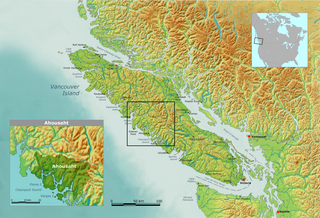
Marktosis, also spelled Maaqtusiis in the Nuu-chah-nulth language, is one of the principal settlements of Ahousaht First Nation, located off the west coast of Vancouver Island in British Columbia, Canada, just southeast of the Hesquiat Peninsula on Flores Island. Accessible only by water or air, Marktosis is a small community predominantly composed of First Nations people from the Nuu-chah-nulth nation. Marktosis has approximately 900 residents.
The Nazko First Nation is a First Nations government of the Dakelh people in the north-central Interior of British Columbia. Its reserves are located around the community of Nazko, British Columbia, which is 120 km west of Quesnel and southwest of Prince George.
The Hartley Bay Indian Band is also known as the Gitga'at First Nation or the Hartley Bay First Nation. The members of the Gitga'at First nation are often referred to as Gitka'a'ata. The population of Gitk’a’ata peoples living in Hartley Bay ranges from approximately 130-200 people. There are also about 400-500 Gitk’a’ata peoples living in Prince Rupert, British Columbia, Canada, a neighboring territory. The Gitk’a’ata people have lived in Hartley Bay for hundreds of years, if not always. Some notable things regarding the Gitga'at First Nation are their economy, geography, government, sports involvement, COVID-19 regulations, and relations.
The Middle River, or in the Carrier language (Dakelh) Dzitl'ainli Koh, is a river in the Omineca Country of the northwestern Central Interior of British Columbia, Canada, flowing southeast from the outlet of Takla Lake into Trembleur Lake over a distance of approximately 35 kilometres (22 mi). The river is part of the route of the Stuart River-Takla Lake salmon run, which comes up the Fraser River via its tributaries the Nechako and Stuart Rivers and terminates at Takla Lake, and the route of the unfinished Dease Lake Extension of the British Columbia Railway runs along the river's left (north) bank. The community of Middle River, including the Dzitline Lee Indian Reserve 9. O K'Ay Wha Cho 26, another Indian reserve, is located on the west bank of the river between Takla and Trembleur Lakes.
The Taku River Tlingit First Nation are the band government of the Inland Tlingit in far northern British Columbia, Canada and also in Yukon. They comprise two ḵwaan (tribes) of the Tlingit people, who are otherwise coastal, the Áa Tlein Ḵwáan of the Atlin Lake area and the Deisleen Ḵwáan of Teslin Lake, whose main focus is the Teslin Tlingit Council in Teslin, Yukon. Their band offices are in Atlin, British Columbia.
Takla Landing, also known as McLaing Landing is an unincorporated locality and former steamboat landing on the east side of Takla Lake in the Omineca Country of the Central Interior of British Columbia, Canada. In the days of the Omineca Gold Rush, Takla Landing was a port for steamboats connecting trails from Hazelton, British Columbia via Babine Lake to trails leading from Takla Landing eastwards to the area of the gold strikes in the lower Omineca River.
The Leq'á:mel First Nation, formerly known as Lakahahmen First Nation, is a First Nations band government whose community and offices are located in the area near Deroche, British Columbia in the Fraser Valley region in Canada, about 12 kilometres east of the District of Mission. They are a member government of the Sto:lo Nation Chiefs Council, which is one of two tribal councils of the Sto:lo.
