
Smart growth is an urban planning and transportation theory that concentrates growth in compact walkable urban centers to avoid sprawl. It also advocates compact, transit-oriented, walkable, bicycle-friendly land use, including neighborhood schools, complete streets, and mixed-use development with a range of housing choices. The term "smart growth" is particularly used in North America. In Europe and particularly the UK, the terms "compact city", "urban densification" or "urban intensification" have often been used to describe similar concepts, which have influenced government planning policies in the UK, the Netherlands and several other European countries.

Zoning is a method of urban planning in which a municipality or other tier of government divides land into areas called zones, each of which has a set of regulations for new development that differs from other zones. Zones may be defined for a single use, they may combine several compatible activities by use, or in the case of form-based zoning, the differing regulations may govern the density, size and shape of allowed buildings whatever their use. The planning rules for each zone determine whether planning permission for a given development may be granted. Zoning may specify a variety of outright and conditional uses of land. It may indicate the size and dimensions of lots that land may be subdivided into, or the form and scale of buildings. These guidelines are set in order to guide urban growth and development.
DPZ CoDesign (DPZ) is an architecture and town planning firm based in Miami, Florida, founded in 1980 by the husband-and-wife team of Andrés Duany and Elizabeth Plater-Zyberk. The firm advocates for New Urbanist town planning in the United States and other countries, having completed designs for over 300 new and existing communities. In addition to Duany and Plater-Zyberk, DPZ's partners include Galina Tachieva, Marina Khoury, Senen M. A. Antonio and Matthew J. Lambert.

New Urbanism is an urban design movement that promotes environmentally friendly habits by creating walkable neighbourhoods containing a wide range of housing and job types. It arose in the United States in the early 1980s, and has gradually influenced many aspects of real estate development, urban planning, and municipal land-use strategies. New Urbanism attempts to address the ills associated with urban sprawl and post-Second World War suburban development.
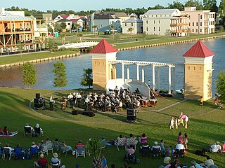
Seaside is an unincorporated master-planned community on the Florida Panhandle in Walton County, between Panama City Beach and Destin. One of the first communities in America designed on the principles of New Urbanism, the town has become the topic of slide lectures in architectural schools and in housing-industry magazines, and is visited by design professionals from all over the United States. On April 18, 2012, the American Institute of Architects's Florida Chapter placed the community on its list of Florida Architecture: 100 Years. 100 Places as the Seaside – New Urbanism Township.

Floor area ratio (FAR) is the ratio of a building's total floor area to the size of the piece of land upon which it is built. It is often used as one of the regulations in city planning along with the building-to-land ratio. The terms can also refer to limits imposed on such a ratio through zoning. FAR includes all floor areas but is indifferent to their spatial distribution on the lot whereas the building coverage ratio measures building footprint on the lot but is indifferent to building height.
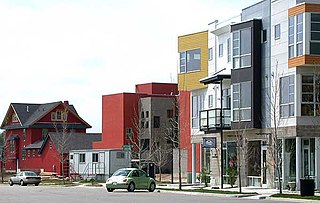
Prospect New Town is a New Urbanist housing development located on the southern edge of the city of Longmont in Boulder County, Colorado, in the United States. The first full-scale new urbanist new development in Colorado, it was developed starting in the mid-1990s by Kiki Wallace and designed by the firm of Duany Plater Zyberk & Company, who also designed the new urbanist communities of Seaside, Florida, and Kentlands in Gaithersburg, Maryland. As of 2009, the project is in its sixth phase of development. It is intended to have a population of approximately 2,000 people in 585 units on 340 lots.

The street hierarchy is an urban planning technique for laying out road networks that exclude automobile through-traffic from developed areas. It is conceived as a hierarchy of roads that embeds the link importance of each road type in the network topology. Street hierarchy restricts or eliminates direct connections between certain types of links, for example residential streets and arterial roads, and allows connections between similar order streets or between street types that are separated by one level in the hierarchy By contrast, in many regular, traditional grid plans, as laid out, higher order roads are connected by through streets of both lower order levels An ordering of roads and their classification can include several levels and finer distinctions as, for example, major and minor arterials or collectors.
The urban-to-ruraltransect is an urban planning model created by the New Urbanist Andrés Duany. The transect defines a series of zones that transition from sparse rural farmhouses to the dense urban core. Each zone is fractal in that it contains a similar transition from the edge to the center of the neighborhood. The transect is an important part of the New Urbanism and smart growth movements. Duany's firm DPZ has embodied the transect philosophy into their SmartCode generic planning code for municipal ordinances.

Coving is a method of Suburban planning used in subdivision and redevelopment of cities characterized by organic lot shapes and home placement along meandering setbacks. When combined with a new form of street patterns, lot area is increased and road area and length is reduced - a demonstrated average 25% compared to conventional suburban platting. Coving is used as an alternative to conventional urban "grid" and suburban land development layouts in order to enhance curb appeal, eliminate monotony, reduce costs, such as road surfacing and street length, while increasing the amount of land available for construction. What makes coving so unique is that it gains its efficiency by increasing instead of decreasing existing regulatory minimums.
A planned unit development (PUD) is a type of flexible, non-Euclidean zoning device that redefines the land uses allowed within a stated land area. PUDs consist of unitary site plans that promote the creation of open spaces, mixed-use housing and land uses, environmental preservation and sustainability, and development flexibility. Areas rezoned as PUDs include building developments, designed groupings of both varied and compatible land uses—such as housing, recreation, commercial centers, and industrial parks—within one contained development or subdivision. Developed areas vary in size and by zoned uses, such as industrial, commercial, and residential. Other types of similar zoning devices include floating zones, overlay zones, special district zoning, performance-based codes, and transferable development rights.
A Form-Based Code (FBC) is a means of regulating land development to achieve a specific urban form. Form-Based Codes foster predictable built results and a high-quality public realm by using physical form as the organizing principle, with less focus on land use, through municipal regulations. An FBC is a regulation, not a mere guideline, adopted into city, town, or county law and offers a powerful alternative to conventional zoning regulation.

Mixed use is a type of urban development, urban design, urban planning and/or a zoning classification that blends multiple uses, such as residential, commercial, cultural, institutional, or entertainment, into one space, where those functions are to some degree physically and functionally integrated, and that provides pedestrian connections. Mixed-use development may be applied to a single building, a block or neighborhood, or in zoning policy across an entire city or other administrative unit. These projects may be completed by a private developer, (quasi-) governmental agency, or a combination thereof. A mixed-use development may be a new construction, reuse of an existing building or brownfield site, or a combination.
SmartCode is a unified land development ordinance template for planning and urban design. Originally developed by Duany Plater-Zyberk & Company, this open source program is a model form-based unified land development ordinance designed to create walkable neighborhoods across the full spectrum of human settlement, from the most rural to the most urban, incorporating a transect of character and intensity within each. It folds zoning, subdivision regulations, urban design, and basic architectural standards into one compact document. Because the SmartCode enables community vision by coding specific outcomes that are desired in particular places, it is meant to be locally calibrated by professional planners, architects, and attorneys.
I'On is a mixed-use New Urbanist Traditional Neighborhood Development (TND) style community located in Mount Pleasant, South Carolina, United States just northeast of Charleston. I'On was one of the earliest full-time residential New Urbanist communities developed in the US.

Secondary suites are self-contained apartments, cottages, or small residential units, that are located on a property that has a separate main, single-family home, duplex, or other residential unit. In some cases, the ADU or in-law is attached to the principal dwelling or is an entirely separate unit, located above a garage or in the backyard on the same property. In British English the term annex or granny annex is used instead. Reasons for wanting to add a secondary suite to a property may be to receive additional income, provide social and personal support to a family member, or obtain greater security.

Medium-density housing is a term used within urban planning and academic literature to refer to a category of residential development that falls between detached suburban housing and large multi-story buildings. There is no singular definition of medium-density housing as its precise definition tends to vary between jurisdiction. Scholars however, have found that medium density housing ranges from about 25 to 80 dwellings per hectare, although most commonly sits around 30 and 40 dwellings/hectare. Typical examples of medium-density housing include duplexes, triplexes, townhouses, row homes, detached homes with garden suites, and walk-up apartment buildings.
SouthField is a form-based code planned community located on the former South Weymouth Naval Air Station in South Weymouth, Massachusetts. It is a 1,400-acre (6 km2) site 12 miles (19 km) south of Boston that overlaps three towns: Weymouth, Abington, and Rockland. Developed by LNR Property Corporation, SouthField will contain 2,855 housing units and up to 2,000,000 square feet (186,000 m2) that include single-family homes, apartments, and townhouses. The site will also have up to 1.7 million square feet of commercial development, a 45-acre recreational facility, an 18-hole golf course, walking trails and 1,000 acres of undeveloped land.

In the United States, zoning includes various land use laws falling under the police power rights of state governments and local governments to exercise authority over privately owned real property. Zoning laws in major cities originated with the Los Angeles zoning ordinances of 1904 and the New York City 1916 Zoning Resolution. Early zoning regulations were in some cases motivated by racism and classism, particularly with regard to those mandating single-family housing. Zoning ordinances did not allow African-Americans moving into or using residences that were occupied by majority whites due to the fact that their presence would decrease the value of home. The constitutionality of zoning ordinances was upheld by the Supreme Court of the United States in Village of Euclid, Ohio v. Ambler Realty Co. in 1926.
Exclusionary zoning is the use of zoning ordinances to exclude certain types of land uses from a given community, especially to regulate racial and economic diversity. In the United States, exclusionary zoning ordinances are standard in almost all communities. Exclusionary zoning was introduced in the early 1900s, typically to prevent racial and ethnic minorities from moving into middle- and upper-class neighborhoods. Municipalities use zoning to limit the supply of available housing units, such as by prohibiting multi-family residential dwellings or setting minimum lot size requirements. These ordinances raise costs, making it less likely that lower-income groups will move in. Development fees for variance, a building permit, a certificate of occupancy, a filing (legal) cost, special permits and planned-unit development applications for new housing also raise prices to levels inaccessible for lower income people.