
In aviation, instrument flight rules (IFR) is one of two sets of regulations governing all aspects of civil aviation aircraft operations; the other is visual flight rules (VFR).

According to the International Civil Aviation Organization (ICAO), a runway is a "defined rectangular area on a land aerodrome prepared for the landing and takeoff of aircraft". Runways may be a human-made surface or a natural surface. Runways, taxiways and ramps, are sometimes referred to as "tarmac", though very few runways are built using tarmac. Takeoff and landing areas defined on the surface of water for seaplanes are generally referred to as waterways. Runway lengths are now commonly given in meters worldwide, except in North America where feet are commonly used.
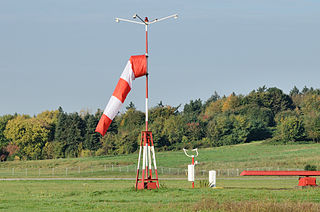
A windsock is a conical textile tube that resembles a giant sock. It can be used as a basic indicator of wind speed and direction, or as decoration. Windsocks are typically used at airports to show the direction and strength of the wind to pilots, and at chemical plants where there is risk of gaseous leakage. They are also sometimes located alongside highways at windy locations.

An airfield traffic pattern is a standard path followed by aircraft when taking off or landing while maintaining visual contact with the airfield.
Aviation is the design, development, production, operation, and use of aircraft, especially heavier-than-air aircraft. Articles related to aviation include:
Airspace is the portion of the atmosphere controlled by a country above its territory, including its territorial waters or, more generally, any specific three-dimensional portion of the atmosphere. It is not the same as outer space which is the expanse or space outside the Earth and aerospace which is the general term for Earth's atmosphere and the outer space within the planet's vicinity. History:

In the case of a radio failure or aircraft not equipped with a radio, or in the case of a deaf pilot, air traffic control may use a signal lamp to direct the aircraft. ICAO regulations require air traffic control towers to possess such signal lamps. The signal lamp has a focused bright beam and is capable of emitting three different colors: red, white and green. These colors may be flashed or steady, and have different meanings to aircraft in flight or on the ground. Planes can acknowledge the instruction by rocking their wings, moving the ailerons if on the ground, or by flashing their landing or navigation lights during hours of darkness. Air traffic control signal light guns are typically specified with a (white) center beam brightness of > 180,000 - 200,000 candela, and are visible for roughly 4 miles in clear daylight conditions. The table below describes the meaning of the signals. The use of handheld combination red/green/white signal lamps for air traffic control dates back to at least the 1930s.
The visual approach slope indicator (VASI) is a system of lights on the side of an airport runway threshold that provides visual descent guidance information during final approach. These lights may be visible from up to 8 kilometres (5.0 mi) during the day and up to 32 kilometres (20 mi) or more at night.

In aviation, an instrument approach or instrument approach procedure (IAP) is a series of predetermined maneuvers for the orderly transfer of an aircraft operating under instrument flight rules from the beginning of the initial approach to a landing, or to a point from which a landing may be made visually. These approaches are approved in the European Union by EASA and the respective country authorities and in the United States by the FAA or the United States Department of Defense for the military. The ICAO defines an instrument approach as "a series of predetermined maneuvers by reference to flight instruments with specific protection from obstacles from the initial approach fix, or where applicable, from the beginning of a defined arrival route to a point from which a landing can be completed and thereafter, if landing is not completed, to a position at which holding or en route obstacle clearance criteria apply."

In aviation, holding is a maneuver designed to delay an aircraft already in flight while keeping it within a specified airspace.
Iowa City Municipal Airport, is two miles southwest of downtown Iowa City, in Johnson County, Iowa. It is the oldest civil airport west of the Mississippi River still in its original location.

An approach lighting system (ALS) is a lighting system installed on the approach end of an airport runway and consisting of a series of lightbars, strobe lights, or a combination of the two that extends outward from the runway end. ALS usually serves a runway that has an instrument approach procedure (IAP) associated with it and allows the pilot to visually identify the runway environment and align the aircraft with the runway upon arriving at a prescribed point on an approach.
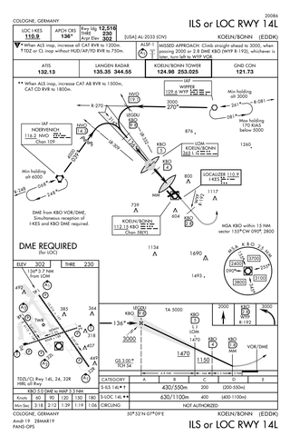
Approach plates are the printed or digital charts of instrument approach procedures that pilots use to fly instrument approaches during instrument flight rules (IFR) operations. Each country maintains its own instrument approach procedures according to International Civil Aviation Organization (ICAO) standards.

The United States airspace system's classification scheme is intended to maximize pilot flexibility within acceptable levels of risk appropriate to the type of operation and traffic density within that class of airspace – in particular to provide separation and active control in areas of dense or high-speed flight operations.
This article describes the graphic conventions used in Sectional charts and Terminal area charts published for aeronautical navigation under Visual Flight Rules in the United States of America. The charts are published "in accordance with Interagency Air Cartographic Committee specifications and agreements, approved by the Department of Defense and the Federal Aviation Administration".

Landing lights are lights, mounted on aircraft, that illuminate the terrain and runway ahead during takeoff and landing, as well as being used as a collision avoidance measure against other aircraft and bird strikes.
The Next Generation Air Transportation System (NextGen) is an ongoing United States Federal Aviation Administration (FAA) project to modernize the National Airspace System (NAS). The FAA began work on NextGen improvements in 2007 and plans to finish the final implementation segment by 2030. The goals of the modernization include using new technologies and procedures to increase the safety, efficiency, capacity, access, flexibility, predictability, and resilience of the NAS while reducing the environmental impact of aviation.

Civil aviation is one of two major categories of flying, representing all non-military and non-state aviation, both private and commercial. Most countries in the world are members of the International Civil Aviation Organization and work together to establish common Standards and Recommended Practices for civil aviation through that agency.

Togiak Airport is a state-owned, public-use airport located in Togiak Village, in the Bethel Census Area of the U.S. state of Alaska.
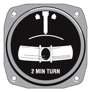
In aviation, the turn and slip indicator and the turn coordinator (TC) variant are essentially two aircraft flight instruments in one device. One indicates the rate of turn, or the rate of change in the aircraft's heading; the other part indicates whether the aircraft is in coordinated flight, showing the slip or skid of the turn. The slip indicator is actually an inclinometer that at rest displays the angle of the aircraft's transverse axis with respect to horizontal, and in motion displays this angle as modified by the acceleration of the aircraft. The most commonly used units are degrees per second (deg/s) or minutes per turn (min/tr).
