
Amsterdam Zuid is a railway station situated in the borough of Amsterdam-Zuid in Amsterdam, Netherlands. For a number of years, it was named Amsterdam Zuid WTC, in reference to the neighbouring World Trade Center Amsterdam. During 2006, in conjunction with the rapid development of the area surrounding the station, the station was enlarged and the reference to the WTC was formally dropped from the name.

The HSL 4 is a Belgian high-speed rail line part of the 87 kilometres (54 mi) axis which connects Antwerp to the Dutch border. It is 40 kilometres (25 mi); 36 kilometres (22 mi) of it being dedicated high speed tracks. It was scheduled for completion by 2005 and opened in 2009.
The Antwerp Premetro is a network consisting of lines 2, 3, 5, 6, 8, 9, 10 and 15 of the Antwerp Tram system. It is a metre gauge system which runs underground in the city centre and further out on surface lines, which are mostly separated from motor vehicle traffic. The network is operated by De Lijn.
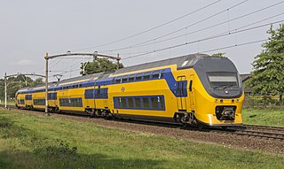
Rail transport in the Netherlands uses a dense railway network which connects nearly all major towns and cities. There are as many train stations as there are municipalities in the Netherlands. The network totals 3,223 route km (2,003 mi) on 6,830 kilometres (4,240 mi) of track; a line may run both ways, or two lines may run on major routes. Three-quarters of the lines have been electrified.

Tramlijn 5 is a tram line operating between Amsterdam and Amstelveen in the Netherlands. Operated by the municipal transport company GVB, the route normally runs between Van Hallstraat in Amsterdam and Stadshart in the neighbouring municipality of Amstelveen. Tram line 5 connects several important areas of the city, including the Zuidas financial district and Leidseplein, and also provides a rapid tram route south of Amsterdam Zuid station to Stadshart, Amstelveen's town centre.

The Amsterdam Tram is a tram network in Amsterdam, Netherlands. It dates back to 1875 and since 1943 has been operated by municipal public transport operator Gemeentelijk Vervoerbedrijf (GVB), which also runs the Amsterdam Metro and the city bus and ferry services. Amsterdam has the largest tram network in the Netherlands and one of the largest in Europe.

The Antwerp premetro tram route 3 is a tram route connecting Merksem with Melsele in the city of Antwerp. The route is operated by the Flemish transport company De Lijn and historically also by its Antwerp predecessor, MIVA.

The Antwerp tramway network is a network of tramways forming part of the public transport system in Antwerp, a city in the Flemish Region of Belgium. The network is operated by the Flemish region's transportation company De Lijn. As of April 2017, it featured fourteen lines, eight of which pass partially underground.

Antwerp is the largest city in Belgium by area at 204.51 km2 (78.96 sq mi) and the capital of Antwerp Province in the Flemish Region. With a population of 536,079, it is the most populous municipality in Belgium, and with a metropolitan population of around 1,200,000 people, it is the second-largest metropolitan region in Belgium, second only to Brussels.

Antwerpen-Zuid is a railway station in the south of the city of Antwerp, Antwerp, Belgium. The old station opened on 10 July 1878 (goods) on the Lines 52 (1894) and 25A (1907). The old station building was demolished in 1965 and replaced with a stop in 1970 on the new through railway under the Scheldt river on the line 59. In 2006, the Butterfly Palace, designed by the Richard Rogers Partnership, was built on the location of the old station. It houses the Antwerp Courthouse.
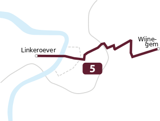
Tram route 5 is a tram route in Antwerp running from Linkeroever to Wijnegem that is operated by the Flemish transport company De Lijn. The modern route was put into service on March 4, 2006, initially connecting Linkeroever with Deurne. The tram route uses the Antwerp pre-metro between the stations Van Eeden and Schijnpoort. On April 14, it was extended from the Wim Saerensplein in Deurne to the Wijnegem Fortveld terminus.
Tram route 8 is a tram route in Antwerp and nearby Wommelgem. The present day route was opened on 8 December 2019 connecting the Astrid premetro station with the Wommelgem Roundabout P+R. The route was the first to use the newly opened premetro tunnel under Borgerhout, called the Reuzenpijp, which begins at Astrid station and comes above ground just before the Muggenberg stop. It is promoted as a "fast tram" (sneltram) route, as most stations in the premetro tunnel have not (yet) been opened, allowing a 15-minute connection between the city center and the Wommelgem P+R.

Tram route 6 is a tram route in Antwerp between the Metropolis P+R in the northern Luchtbal suburb and the Olympiade P+R in the southern Kiel neighborhood, using the pre-metro network between stations Sport and Plantin. The route was officially opened on 27 October 2007 and is operated by the Flemish transport company De Lijn.

Opera is a station in the Antwerp premetro network, lying under the Leien near the Teniersplaats in the city centre. The station was opened on March 25, 1975, at the initial opening of the Antwerp premetro network. The station was temporarily closed in 2016 in order to undergo a full renovation and expansion and reopened in its current form on December 8, 2019. The station lies in the immediate proximity of the Antwerp opera building and is a part of the central east-west premetro axis. It is served by the tram routes 3, 5, 9, 10 and 15.

Astrid is a station in the Antwerp premetro network that was opened on April 1, 1996. The station lies directly under the Koningin Astridplein on the Gemeentestraat side. The station is one of the two premetro stations in Antwerp servicing passengers from Antwerp Central Station, the other being Diamant, which lies to the south of Astrid. It is served by tram lines 8 and 10, who both terminate in this station.

Tram route 9 is a route in the Antwerp tram network connecting the Eksterlaar neighborhood in southern Deurne with Linkeroever using the Antwerp premetro network between Plantin and Van Eeden stations. The present day route was officially opened on September 1, 2012, as part of a revision of the network map.

Tram route 11 is an above ground tram route in the city of Antwerp, Belgium. It currently runs between the Antwerpen-Berchem railway station and the Melkmarkt in the city centre.
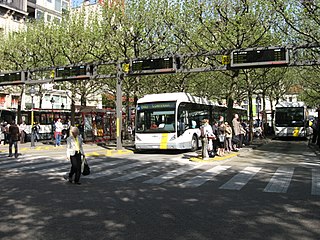
The Franklin Rooseveltplaats is a large square in the city of Antwerp, Belgium, placed at the crossing of the Leien and Turnhoutsebaan, and within walking distance of the Koningin Astridplein and Antwerp-Central station. The square functions primarily as the main bus station in Antwerp, which with its 28 platforms handles a large part of all bus transport in the city, as well as several tram routes.

Tram route 4 is an above ground tram route in the city of Antwerp, Belgium. The route runs between the Kioskplaats in the suburb of Hoboken in the South, and the Silsburg cemetery on the Deurne/Wommelgem border in the East. The present day itinerary is the result of the merger of the trajectory from the historic route 8 and that from the original route 4 in 2012.
Tram Route 10 is a tram route in Antwerp and nearby Wijnegem. Tram route 10 entered operation in 1873, making it one of the oldest tram routes still active in Antwerp, next to Tram Route 4 (Antwerp) and Tram Route 7 (Antwerp).

