Related Research Articles

The Ohio River is a 981-mile-long (1,579 km) river in the United States. It is located at the boundary of the Midwestern and Southern United States, flowing in a southwesterly direction from western Pennsylvania to its mouth on the Mississippi River at the southern tip of Illinois. It is the third largest river by discharge volume in the United States and the largest tributary by volume of the north-south flowing Mississippi River, which divides the eastern from western United States. It is also the sixth oldest river on the North American continent. The river flows through or along the border of six states, and its drainage basin includes parts of 14 states. Through its largest tributary, the Tennessee River, the basin includes several states of the southeastern U.S. It is the source of drinking water for five million people.

Appalachia is a geographic region located in the central and southern sections of the Appalachian Mountains of the eastern United States. In the north, its boundaries stretch from the western Catskill Mountains of New York, continuing south through the Blue Ridge Mountains and Great Smoky Mountains into northern Georgia, Alabama, and Mississippi, with West Virginia near the center, being the only state entirely within the boundaries of Appalachia. In 2021, the region was home to an estimated 26.3 million people.

The Transylvania Colony, also referred to as the Transylvania Purchase or the Henderson Purchase, was a short-lived, extra-legal colony founded in early 1775 by North Carolina land speculator Richard Henderson, who formed and controlled the Transylvania Company. Henderson and his investors had reached an agreement to purchase a vast tract of Cherokee lands west of the southern and central Appalachian Mountains through the acceptance of the Treaty of Sycamore Shoals with most leading Cherokee chieftains then controlling these lands. In exchange for the land the tribes received goods worth, according to the estimates of some scholars, about 10,000 British pounds. To further complicate matters, this frontier land was also claimed by the Virginia Colony and a southern portion by Province of North Carolina.
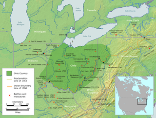
The Ohio Country was a name used for a loosely defined region of colonial North America west of the Appalachian Mountains and south of Lake Erie.

The Allegheny Mountain Range, informally the Alleghenies, is part of the vast Appalachian Mountain Range of the Eastern United States and Canada and posed a significant barrier to land travel in less developed eras. The Allegheny Mountains have a northeast–southwest orientation, running for about 300 miles (480 km) from north-central Pennsylvania southward, through western Maryland and eastern West Virginia.

The Ridge-and-Valley Appalachians, also called the Ridge and Valley Province or the Valley and Ridge Appalachians, are a physiographic province of the larger Appalachian Highlands division. The physiographic province is divided into three sections: the Hudson Valley, the Central, and the Tennessee.

The state cessions are the areas of the United States that the separate states ceded to the federal government in the late 18th and early 19th centuries. The cession of these lands, which for the most part lay between the Appalachian Mountains and the Mississippi River, was key to establishing a harmonious union among the former British colonies.
The Wilderness Road was one of two principal routes used by colonial and early national era settlers to reach Kentucky from the East. Although this road goes through the Cumberland Gap into southern Kentucky and northern Tennessee, the other is sometimes called the "Cumberland Road" because it started in Fort Cumberland in Maryland. Despite Kentucky Senator Henry Clay's advocacy of this route, early in the 19th century, the northern route was selected for the National Road, connecting near Washington, Pennsylvania into the Ohio Valley of northern Kentucky and Ohio.
The "Old Southwest" is an informal name for the southwestern frontier territories of the United States from the American Revolutionary War c. 1780, through the early 1800s, at which point the US had acquired the Louisiana Territory, pushing the southwestern frontier toward what is today known as the Southwest.

Kentucky County, later the District of Kentucky, was formed by the Commonwealth of Virginia from the western portion of Fincastle County effective 1777. The name of the county was taken from a Native American place name that came to be associated with a river in east central Kentucky, and gave the Kentucky River its name and eventually the U.S. state of Kentucky. During the almost four years of Kentucky County's existence, its seat of government was Harrodstown.
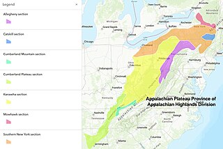
The Appalachian Plateau is a series of rugged dissected plateaus located on the western side of the Appalachian Mountains. The Appalachian Mountains are a range that run from Nova Scotia in Canada to Alabama in the United States.
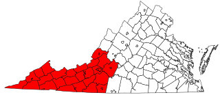
Southwest Virginia, often abbreviated as SWVA, is a mountainous region of Virginia in the westernmost part of the commonwealth. Located within the broader region of western Virginia, Southwest Virginia has been defined alternatively as all Virginia counties on the Appalachian Plateau, all Virginia counties west of the Eastern Continental Divide, or at its greatest expanse, as far east as Blacksburg and Roanoke. Another geographic categorization of the region places it as those counties within the Tennessee River watershed. Regardless of how borders are drawn, Southwest Virginia differs from the rest of the commonwealth in that its culture is more closely associated with Appalachia than the other regions of Virginia. Historically, the region has been and remains a rural area, but in the 20th century, coal mining became an important part of its economy. With the decline in the number of coal jobs and the decline of tobacco as a cash crop, Southwest Virginia is increasingly turning to tourism as a source of economic development. Collectively, Southwest Virginia's craft, music, agritourism and outdoor recreation are referred to as the region's "creative economy."

The prehistory and history of Kentucky span thousands of years, and have been influenced by the state's diverse geography and central location. Archaeological evidence of human occupation in Kentucky begins approximately 9,500 BCE. A gradual transition began from a hunter-gatherer economy to agriculture c. 1800 BCE. Around 900 CE, the Mississippian culture took root in western and central Kentucky; the Fort Ancient culture appeared in eastern Kentucky. Although they had many similarities, the Fort Ancient culture lacked the Mississippian's distinctive, ceremonial earthen mounds.

A longhunter was an 18th-century explorer and hunter who made expeditions into the American frontier for as much as six months at a time.

The Upland South and Upper South are two overlapping cultural and geographic subregions in the inland part of the Southern United States. They differ from the Deep South and Atlantic coastal plain by terrain, history, economics, demographics, and settlement patterns.
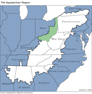
Appalachian Ohio is a bioregion and political unit in the southeastern part of the U.S. state of Ohio, characterized by the western foothills of the Appalachian Mountains and the Appalachian Plateau. The Appalachian Regional Commission defines the region as consisting of thirty-two counties. This region roughly overlaps with the Appalachian mixed-mesophytic forests, which begin in southeast Ohio and southwest Pennsylvania and continue south to Georgia and Alabama. The mixed-mesophytic forest is found only in Central and Southern Appalachia and eastern/central China. It is one of the most biodiverse temperate forests in the world.

"Indian Reserve" is a historical term for the largely uncolonized land in North America that was claimed by France, ceded to Great Britain through the Treaty of Paris (1763) at the end of the Seven Years' War—also known as the French and Indian War—and set aside for the First Nations in the Royal Proclamation of 1763. The British government had contemplated establishing an Indian barrier state in a portion of the reserve west of the Appalachian Mountains, bounded by the Ohio and Mississippi rivers and the Great Lakes. British officials aspired to establish such a state even after the region was assigned to the United States in the Treaty of Paris (1783) ending the American Revolutionary War, but abandoned their efforts in 1814 after losing military control of the region during the War of 1812.

Moccasin Gap, also known as Big Moccasin Gap, is a pass in Clinch Mountain, a long ridge within the Appalachian Mountains, at Gate City, Virginia. This gap has a long history as a passageway through the mountain. It was used by the Cherokee and Shawnee, and was the first gap through which the Daniel Boone Wilderness Road passed on its way to the better-known Cumberland Gap and Kentucky. Today it serves as a primary commercial route for industry, retail, and tourism businesses.
The Boonslick, or Boone's Lick Country, is a cultural region of the state of Missouri along the Missouri River that played an important role in the westward expansion of the United States and the development of Missouri's territorial and subsequent statehood in the early 19th century. The Boone's Lick Road, a longtime historic route paralleling the north bank of the Missouri River from southeast to northwest, between St. Charles and Franklin, Missouri. It was the primary thoroughfare for settlers moving westward from the major river port on the Mississippi River of St. Louis and the first capital of the old federal Missouri Territory (1812-1821), in the early 19th century. St. Louis was also a major settlement town since the 17th and 18th century era along with the nearby, across the river upstream to the east, of French colonial settlements Kaskaskia and Cahokia in the adjacent Illinois Country of the New France colonial empire of the old Kingdom of France, leading from its capital in Quebec in the north, and east of the Great Lakes and extending southward through the central Mississippi River Valley down to the lower river port of New Orleans on the Gulf of Mexico and in French Louisiana, the heartland and central watershed of the North American continent. St. Louis was also important because of its proximity to the confluence of the central Mississippi with the Ohio River flowing from the northeast and the Missouri River streaming from the far western Rocky Mountains northwest in the earlier federal Louisiana Territory (1804-1812), organized after the sale of the huge uncharted Louisiana Purchase of 1803, from the Emperor Napoleon I / Napoleon Bonaparte of France for $15 million dollars
References
- 1 2 "Geog 366". web.pdx.edu. Retrieved 2023-05-23.
- ↑ "CFP - The Making of the Trans-Appalachian West: Society, Culture, and Peoples, 1754-1832 | H-Appalachia | H-Net". networks.h-net.org. Retrieved 2023-05-23.
- ↑ Arnold, Richard Keith (February 26, 2010). "A CRITICAL HISTORY OF COLONIZATION AND AMERINDIAN RESISTANCE IN TRANS-APPALACHIA 1750-1830: THE PROCLAMATION WARS" (PDF).
- ↑ James, Lauren C. (May 2012). ""The American Canaan": Eighteenth century Trans-Appalachian migration".
- ↑ Furstenberg, François (June 1, 2008). "The Significance of the Trans-Appalachian Frontier in Atlantic History". The American Historical Review . 113 (3): 647–677. doi: 10.1086/ahr.113.3.647 . Archived from the original on 2018-06-06. Retrieved 26 May 2023.
- ↑ Bartosik-Vélez, Elise (2014). Columbus and the Republican Empire of the United States. Vanderbilt University Press.