
Ridgewood Park, also known as Wallace's Ridgewood Park or the Wallace Grounds, and frequently confused with Grauer's Ridgewood Park, was a baseball ground in Ridgewood, Queens, New York. Both Wallace's and Grauer's are shown in Belcher Hyde's Map of Newtown in 1915. The baseball field was part of a larger entertainment area bounded Wyckoff Avenue, Covert Street, Halsey Street, and Irving Avenue. The baseball field was southwest of the Long Island Rail Road's Montauk Branch tracks. Eldert Street, although depicted on the map as running through the baseball grounds, was not cut through southwest of the railroad tracks and the road remains interrupted there today. Originally the park was in Queens County, before its incorporation into New York City in 1899. This facilitated Sunday baseball playing, including the charging of admission, beyond the reach of Sabbath enforcers from the then-city of Brooklyn.
Mount Prospect Park is a 7.79-acre (3.15 ha) park in the central portion of the New York City borough of Brooklyn. It includes Mount Prospect, the second highest point in Brooklyn. It is located on Eastern Parkway near Underhill Avenue, close to Grand Army Plaza. The park is operated by the New York City Department of Parks and Recreation.

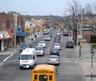
Glendale is a neighborhood in the west-central portion of the New York City borough of Queens. It is bounded by Forest Hills to the east, Ridgewood to the west, Woodhaven to the south, and Middle Village to the north.
Vanderbilt Avenue is the name of three thoroughfares in the New York City boroughs of Brooklyn, Manhattan, and Staten Island. They were named after Cornelius Vanderbilt (1794–1877), the builder of Grand Central Terminal in Midtown Manhattan.

DeKalb Avenue is a thoroughfare in the New York City boroughs of Brooklyn and Queens, with the majority of its length in Brooklyn.

Rockaway Parkway is a major commercial street in the Canarsie and Brownsville neighborhoods of Brooklyn, New York. It occupies the position of East 97th Street in the Brooklyn street grid.
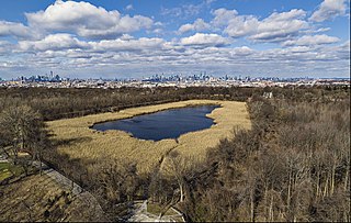
Ridgewood Reservoir is a decommissioned 19th century reservoir and freshwater wetland on the border between the New York City boroughs of Brooklyn and Queens, within what is now Highland Park. Although the reservoir was originally built to secure a reliable water supply for the City of Brooklyn, it is positioned on the Queens side of the border in the neighborhood of Glendale. The reservoir and park are bounded on the north by the Jackie Robinson Parkway, on the south by Highland Boulevard, on the west by Vermont Place and on the east by Cypress Hills National Cemetery.
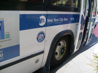
MTA Regional Bus Operations operates local and express buses serving New York City in the United States out of 29 bus depots. These depots are located in all five boroughs of the city, plus one located in nearby Yonkers in Westchester County. 21 of these depots serve MTA New York City Transit (NYCT)'s bus operations, while the remaining eight serve the MTA Bus Company These facilities perform regular maintenance, cleaning, and painting of buses, as well as collection of revenue from bus fareboxes. Several of these depots were once car barns for streetcars, while others were built much later and have only served buses.
The Brooklyn–Queens Greenway is a bicycling and pedestrian path connecting parks and roads in the New York City boroughs of Brooklyn and Queens, connecting Coney Island in the south to Fort Totten in the north, on Long Island Sound. The route connects major sites in the two boroughs, such as the New York Aquarium, Brooklyn Museum, the Brooklyn Botanic Garden, the New York Hall of Science, and Citi Field.
Wingate is a neighborhood in the north central portion of the New York City borough of Brooklyn. The area is bordered by Prospect Lefferts Gardens to the west, Crown Heights to the north and east, and East Flatbush to the south. Wingate is bounded by Empire Boulevard to the north, Troy Avenue to the east, Winthrop Street to the south, and New York Avenue to the west. The area is part of Brooklyn Community District 9. It is sometimes considered part of Crown Heights, East Flatbush, and/or Prospect Lefferts Gardens.

Sedgwick Avenue is a major street in the Bronx, New York City. It runs roughly parallel to Jerome Avenue, the Major Deegan Expressway, and University Avenue. Sedgwick Avenue is one of the longest streets in the western part of the Bronx, running from Mosholu Parkway at the north to Macombs Dam Bridge at its southern end, about 800 feet west of Yankee Stadium.
Conduit Avenue is an arterial road in New York City, the vast majority of which is in Queens. The divided highway runs from Atlantic Avenue in Cypress Hills, Brooklyn to Hook Creek Boulevard in Rosedale, Queens at the Nassau County border. The thoroughfare is named after an aqueduct in its right-of-way.
Metropolitan Avenue is a major east-west street in Queens and northern Brooklyn, New York City. Its western end is at the East River in Williamsburg, Brooklyn, and the eastern end at Jamaica Avenue in Jamaica, Queens. The avenue was constructed in 1816 as the Williamsburgh and Jamaica Turnpike, though previously it served as an Indian trail.
William H. Maxwell Career and Technical High School is a vocational high school in Brooklyn, New York. It lies on Pennsylvania Avenue in the upper half of the East New York neighborhood, close to Liberty Avenue subway station on the C train. The building was built in 1912, but it was re-chartered as a high school in 1950. The school offers vocational training in a variety of subjects, including cosmetology, fashion, medical assisting and related visual instruction.

Queens Metropolitan High School (QMHS) is a public high school in Forest Hills in Queens, New York. It is generally referred to simply as "QMHS," "Metro", or just "'Queens Metro" by the students. It is on the south side of Metropolitan Avenue in the Metropolitan Avenue Educational Campus at 91-30 Metropolitan Avenue, between a former Long Island Rail Road branch and 69th Avenue.
George Westinghouse Career and Technical Education High School is a vocational high school in Downtown Brooklyn, New York, United States. It is located at 105 Tech Place, south of Tillary Street and east of Jay Street. It is named after the electrical pioneer George Westinghouse Jr.
Harold Erickson Kebbon Sr. was an American architect who designed over 100 schools as well as several post offices, courthouses, housing developments and private residences.

The Q58 and Q58 Limited are bus routes that constitute a public transit line operating primarily in Queens, New York City, with its southern terminal on the border with Brooklyn. The Q58 is operated by the MTA New York City Transit Authority. Its precursor was a streetcar line that began operation in November 1899. and was known variously as the Flushing–Ridgewood Line, the Corona Avenue Line, and the Fresh Pond Road Line. The route became a bus line in 1949.

The Q72 bus route constitutes a public transit route along Junction Boulevard and 94th Street in Queens, New York City. It operates between the Rego Park and East Elmhurst neighborhoods of Queens, and extends into LaGuardia Airport at the north end of the borough. It is city-operated under the MTA Bus Company brand of MTA Regional Bus Operations.

