Transport in Botswana

Last updated
Flag of Botswana Flag of Botswana.svg
Flag of Botswana

Transportation in Botswana is provided by an extensive network of railways, highways, ferry services and air routes that criss-cross the country. [1] The transport sector in Botswana played an important role in economic growth following its independence in 1966. The country discovered natural resources which allowed it to finance the development of infrastructure, and policy ensured that the transport sector grew at an affordable pace commensurate with demands for services. [2]

Contents

Rail transport

Rail services are provided by Botswana Railways, with most routes radiating from Gaborone. Botswana has the 93rd longest railway network in the world at 888 km, it is one of the busiest railways in Africa. The track gauge is 1,067 mm (3 ft 6 in) (cape gauge). Botswana is an associate member of the International Union of Railways (UIC).

The new chairs of BR Express BR Express Interior 1.jpg
The new chairs of BR Express

Regional trains (BR Express)

Botswana Railways run 2 nightly passenger trains, one from Lobatse to Francistown, and the other from Francistown to Lobatse, with stops in Gaborone, Mahalapye, Palapye, and Serule. The passenger train is termed the "BR Express" (Botswana Railways). Passenger services were suspended from 2009 to 2016, with the exception of an international link to Zimbabwe from Francistown.

BR Express Interior.jpg

Commuter/suburban trains

In Botswana, the (Botswana Railways) "BR Express" has a commuter train between Lobatse and Gaborone. The train departs to Lobatse at 0530hrs and arrives at Gaborone at 0649hrs. This train returns to Lobatse in the evening, departing in Gaborone at 1800hrs. Arrival time at Lobatse is 1934hrs. The train stops at Otse, Ramotswa, and Commerce Park Halt.

BR Express Sleeping & Dining Department

BR Express Dining Department BR Express Dining Department.jpg
BR Express Dining Department

From the beginning, the BR decided to operate its own sleeping cars, thus building bigger-sized berths and more comfortable surroundings. Providing and operating their cars allowed better control of the services and revenue. While the food was served to passengers, the profits were never result of serving the food. Those who could afford to travel great distances expected better facilities, and favorable opinions from the overall experience would attract others to Botswana and the BR's trains.

Stations

Freight trains

Freight Train of Botswana Botswana Rail Express train3.jpg
Freight Train of Botswana

Over half of BRs freight traffic is in coal, grain and intermodal freight, and it also ships automotive parts and assembled automobiles, sulphur, fertilizers, other chemicals, soda ash, forest products and other types of the commodities.

Locomotives

BR Express Train from Gaborone to Francistown BR Express 1.jpg
BR Express Train from Gaborone to Francistown
BR Express 2.jpg

Diesel locomotives

As of March 2009:

Network

Botswana rail network Botswana rail network map.svg
Botswana rail network

Existing

Currently under construction

Proposed

Road transport

Vehicle population

Bus on the A1l Bus for mass travel.jpg
Bus on the A1l
Cargo Trucking o the A3 Cargo Trucking.jpg
Cargo Trucking o the A3

A-roads

A-roads are highways and other major roads.

RoadConnections
A1 Zimbabwe (A7) - Ramokgwebane (B315) - Tshesebe (B311) - Francistown (A3, B162) - Dikabeya (B151) - Serule (A15) - Palapye (A14, B140) - Mahalapye (B145, B147) - Pilane (B130) - Gaborone (A10, A12) - Ramotswa (A11, B111) - Otse (B105) - Lobatse (A2) - Ramatlabama (B202) - South Africa (R503)
A2 Namibia (B6) - Charleshill (B214) - A3 (south of Ghanzi) - Morwamosu (B102) - Sekoma (A20) - Kanye (A10, B105, B202) - Lobatse (A1) - South Africa (N4)
A3 A2 - Ghanzi - Sehithwa (A35) - Maun (B334) - Matopi (B300) - Nata (A33) - Dukwe (A32) - Sebina (A31) - Francistown (A30, A1)
A10 Gaborone (A1, A12) - Thamaga (B111) - Mosopa - Kanye (A2, B105, B202)
A11 A1 - Ramotswa
A12 Molepolole (B102, B111, B112) - Metsimotlhaba (B122) - Gaborone (A1) - South Africa (R49)
A14 Orapa (A30, B300) - Serowe (B145) - Palapye (A1, B140)
A15 Serule (A1) - Selebi Phikwe (B157, B150)
A20 Sekoma (A2) - Khakhea (B205) - Tshabong (B210, B211)
A30 Orapa (A14, B300) - Francistown (A3)
A31 Tutume - Sebina (A3)
A32 Sowa - Dukwe (A3)
A33 Namibia (B6) - Muchenje - Kasane - Pandamatenga (B333) - Nata (A3)
A35 Namibia - Shakawe - Sehithwa (A3)

B-roads

B-roads are smaller distributor roads.

RoadConnections
B102Morwamosu (A2) - Molepolole (A12, B111, B112)
B105Kanye (A2, A10, B202) - Otse (A1)
B111Molepolole (A12, B102, B112) - Thamaga (A10) - Ramotswa (A1, A11)
B112Shoshong (B145) - Molepolole (A12, B102, B111)
B122Lentsweletau (B123) - Metsimotlhaba (A12)
B123Lentsweletau (B122) - east
B130Pilane (A1) - Mochudi - Sikwane (B135) - South Africa
B135Malolwane - Sikwane (B130)
B140Palapye (A1, A14) - Sherwood (B141) - South Africa (Grobler's Bridge, N11)
B141Machaneng (B147, B148) - Sherwood (B140)
B145Serowe (A14) - Shoshong (B112) - Mahalapye (A1, B147)
B147Mahalapye (A1, B145) - Machaneng (B141, B148)
B148B140 - Machaneng (B141, B147)
B150Selebi Phikwe (A15) - Sefophe (B150) - Tsetsebjwe
B151Dikabeya (A1) - Sefophe (B151) - Bobonong (B155) - Kobojango
B155Bobonong (B150) - Molalatau
B157Mmadinare - Selebi Phikwe (A15)
B162Francistown (A1, A3) - Matsiloje
B202Kanye (A2, A10, B105) - Ramatlabama (A1)
B205A2 - Khakhea (A20) - south
B210Tshabong (A20, B211) - South Africa (R380)
B211South Africa - Bokspits - Tshabong (A20, B210)
B214Charleshill (A2) - Ncojane
B300Matopi (A3) - Rakops - Orapa (A14, A30)
B311Masunga (B316) - Tshesebe (A1)
B315Zwenshambe (B316) - Moroka - Ramokgwebane (A1)
B316Zwenshambe (B315) - Masunga (B311)
B333A33 - Pandamatenga - Zimbabwe
B334Shorobe - Maun (A3)

Motorways

Motorways in Botswana have a set of restrictions, which prohibit certain traffic from using the road. The following classes of traffic are not allowed on Botswana motorways:

Rules for driving on motorways include the following:

The general motorway speed limit is 120 km/h. [4]

Road signs

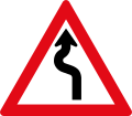
Botswana's old "caution curves" sign SACU road sign W208.svg
Botswana's old "caution curves" sign
New sign SADC road sign W209.svg
New sign

Traditionally, road signs in Botswana used blue backgrounds rather than the yellow, white, or orange that the rest of the world uses on traffic warning signs. In the early 2010s, officials announced plans to begin phasing out the distinctive blue signs in favour of more typical signs in order to be more in line with the neighbouring Southern African Development Community member states. [5]

Interchanges

Existing

  • Kenneth Nkhwa Interchange at the junction of A1 / Blue Jacket Street and A3 in Francistown. [6] [7]
  • Boatle Interchange in Boatle.

Under construction

The Government of Botswana is building three interchanges along K.T Motsete Drive (Western Bypass) in Gaborone. This project started in August 2019, and deadline date is set 2022.

Longest bridges

The Kazungula Bridge in Kazungula [8] and the Okavango River Bridge (constructed 2022) in Mohembo are the two longest bridges.

Existing

Mass transit by road

Taxicabs

In most parts of Botswana, there are many taxicabs of various colours and styles. Botswana has no limitation in taxicab design, so each taxicab company adopts its own design.

Minibus taxis

Combi (Minibus taxi) Public transport in Gaborone.jpg
Combi (Minibus taxi)

Minibus taxis, also known as Combi, are the predominant form of transport for people in urban areas of Botswana. Most of them are found within cities, towns, major villages, and even the least populated areas.

They also have their own minibus station within a particular area; only transporting people within that specific area using different and unique routes. This is due to their availability and affordability to the public.

Most minibus taxis do not have a specific departure time that is allocated by the state and most of them have 15-seaters. The minibuses are owned and operated by many individual minibus owners.

Coach bus

Coach buses are used for longer-distance services within and outside Botswana. These are normally operated by private companies and are the only buses that have departure times allocated by the Ministry of Transport. Coach buses have multiple departures, routes, and stations all over Botswana.

Water transport

Border crossing (ferry) from Botswana to Zambia Border crossing (ferry) from Botswana to Zambia - panoramio.jpg
Border crossing (ferry) from Botswana to Zambia

Ferries

The Kazungula Ferry was a pontoon ferry that crossed the 400-metre-wide (1,300 ft) Zambezi River between Botswana and Zambia.

Tour boats

Aviation

Sir Seretse Khama International Airport in Gaborone, Botswana Aeropuerto Internacional Sir Seretse Khama de Gaborone, Botswana.jpg
Sir Seretse Khama International Airport in Gaborone, Botswana

In 2004 there were an estimated 85 airports, 10 of which (as of 2005), were paved. The country's main international airport is Sir Seretse Khama International Airport in Gaborone. The government-owned Air Botswana operates scheduled flights to Francistown, Gaborone, Maun, and Selebi-Phikwe. There is international service to Johannesburg, South Africa; Mbabane, Eswatini; and Harare, Zimbabwe. A new international airport near Gaborone was opened in 1984. Air passengers arriving to and departing from Botswana during 2003 totalled about 183,000.

Maun International Airport Maun Airport.jpg
Maun International Airport

International airports

Botswana has 4 international airports.

Kasane International Airport Kasane Airport (2919).jpg
Kasane International Airport

Proposed airports

  • "Mophane International Airport" is planned in Palapye Sub-District near Moremi village.

Pedestrian elevated walkways

Gaborone's Pedestrian Elevated Walkway Gaborone, Station bridge 2.jpg
Gaborone's Pedestrian Elevated Walkway

Botswana has many pedestrian elevated walkways at different places.

Water pipelines

Botswana NSC and extension Botswana NSC and Extension.svg
Botswana NSC and extension

[ relevant? ]

Under construction

North-South Carrier

NSC is a pipeline in Botswana that carries raw water, south for a distance of 360 kilometres (220 mi) to the capital city of Gaborone. It was done in phases. However, phase 1 was completed in 2000.

Phase 2 of the NSC, still under construction, will duplicate the pipeline to carry water from the Dikgatlhong Dam, which was completed in 2012.

A proposed extension to deliver water from the Zambezi would add another 500 to 520 kilometres (310 to 320 mi) to the total pipeline length.

Lesotho-Botswana Water Transport

The Lesotho-Botswana Water Transfer is an ongoing project which is expected to provide two hundred million cubic meters per year to transfer water to the south-eastern parts of Botswana.

The scheme involves the supply of water to Gaborone from Lesotho via a 600 to 700 kilometres (370 to 430 mi) pipeline.

The project commenced on the 1 August 2018 and is set for completion in June 2020.

Proposed

Sea water desalination project

The Government of Botswana intends to sign the Sea Water Desalination Project from Namibia. The project is at a tendering stage.

Border posts

Pandamatenga Border Post Sign Pandamatenga Border Post Sign by Meraj Chhaya.jpg
Pandamatenga Border Post Sign
BW Tour boats Elephant swimming, Botswana.jpg
BW Tour boats

See also

Related Research Articles

Different methods of transportation in South Africa include roads, railways, airports, water, and pipelines for petroleum oil. The majority of people in South Africa use informal minibus taxis as their main mode of transport. BRT has been implemented in some South African cities in an attempt to provide more formalised and safer public transport services. These systems have been widely criticised due to their large capital and operating costs. A "freeway" is different from most countries as certain things are forbidden which include certain motorcycles, no hand signals, and motor tricycles. South Africa has many major ports including Cape Town, Durban, and Port Elizabeth that allow ships and other boats to pass through, some carrying passengers and some carrying petroleum tankers.

<span class="mw-page-title-main">Gaborone</span> Capital and the largest city of Botswana

Gaborone is the capital and largest city of Botswana with a population of 246,325 based on the 2022 census, about 10% of the total population of Botswana. Its agglomeration is home to 421,907 inhabitants at the 2011 census.

<span class="mw-page-title-main">Palapye</span> Town in Central District, Botswana

Palapye is a growing town in Botswana, situated about halfway between Francistown and Gaborone. Over the years its position has made it a convenient stopover on one of Southern Africa's principal north–south rail and road routes.

Air Botswana Corporation is Botswana's state-owned national flag carrier, with its headquarters located in Gaborone. It operates scheduled domestic and regional flights from its main base at Sir Seretse Khama International Airport. Air Botswana has been loss-making for several years, and there have been various attempts to privatise the company, and frequent changes to the corporation's management and board, so far without reducing the losses.

The government of Zimbabwe is the main provider of air, rail and road services; historically, there has been little participation of private investors in transport infrastructure.

<span class="mw-page-title-main">Francistown</span> City in North-East District, Botswana

Francistown is the second-largest city in Botswana, with a population of about 103,417 and 147,122 inhabitants for its agglomeration at the 2022 census. It is located in eastern Botswana, about 400 kilometres (250 mi) north-northeast from the capital, Gaborone. Francistown is located at the confluence of the Tati and Ntshe rivers, and near the Shashe River and 90 kilometres (56 mi) from the international border with Zimbabwe.

<span class="mw-page-title-main">Kasane</span> Place in Chobe District, Botswana

Kasane is a town in Botswana, close to Africa's 'Four Corners', where four countries almost meet: Botswana, Namibia, Zambia and Zimbabwe. It is at the far north-eastern corner of Botswana where it serves as the administrative center of the Chobe District. The population of Kasane was 9,244 in 2011 census.

<span class="mw-page-title-main">Botswana Railways</span> National railway operator of Botswana

Botswana Railways (BR) is the national railway of Botswana.

Ramokgwebana is a village in the North-East District of Botswana, close to the eastern border, which is defined by the Ramokgwebana River. Plumtree, Zimbabwe is on the other side of the border crossing.

<span class="mw-page-title-main">Rail transport in Botswana</span> Rail Transport in Botswana

Rail services in Botswana are provided by Botswana Railways in Botswana. Most routes in the country radiate from Gaborone. The railway network consists of 888 km, its gauge is 1,067 mm cape gauge.

<span class="mw-page-title-main">Kazungula Ferry</span> Pontoon ferry across the Zambezi River

The Kazungula Ferry was a pontoon ferry across the 400-metre-wide (1,300 ft) Zambezi River between Botswana and Zambia. It was one of the largest ferries in south-central Africa, having a capacity of 70 tonnes. The service was provided by two motorised pontoons and operated between border posts at Kazungula, Zambia and Kazungula, Botswana.

<span class="mw-page-title-main">Shashe River</span> River in Botswana, Zimbabwe

The Shashe River is a major left-bank tributary of the Limpopo River in Zimbabwe. It rises northwest of Francistown, Botswana and flows into the Limpopo River where Botswana, Zimbabwe and South Africa meet. The confluence is at the site of the Greater Mapungubwe Transfrontier Conservation Area.

List of Railway stations in Botswana include:

<span class="mw-page-title-main">A1 road (Botswana)</span> Road in Botswana

The A1 highway in Botswana is a road that runs from the Zimbabwean border near Ramokgwebana through Francistown, Mahalapye, Palapye, Gaborone and Lobatse, to Ramatlabama at the border with South Africa. Crossing the Ramokgwebana River into Zimbabwe, it continues as the A7 to Bulawayo. On the South African end it continues as the N18 to Mahikeng.

The A2 highway is a road in Botswana running from the Namibian border at Buitepos through Jwaneng, Kanye and Lobatse to the South African border at Pioneer Gate.

<span class="mw-page-title-main">Bechuanaland National Airways</span> Former southern African airline

Bechuanaland National Airways was the national airline of the Bechuanaland Protectorate and was based in Francistown.

<span class="mw-page-title-main">First Capital Bank Botswana Limited</span> Commercial bank in Botswana

First Capital Bank Botswana Limited, formerly known as Capital Bank, is a commercial bank in Botswana, licensed by the Bank of Botswana, the central bank and national banking regulator. It is a subsidiary of FMBCapital Holdings Plc, a Mauritius-based financial services conglomerate, whose shares of stock are listed on the Malawi Stock Exchange and has subsidiaries in Botswana, Malawi, Mozambique, Zambia and Zimbabwe.

Prostitution in Botswana is not illegal, but laws such as public disorder, vagrancy, loitering and state recognised religious provisions are used to prosecute prostitutes. Related activities such as soliciting and brothel keeping are illegal. Botswana has made proposals to make prostitution legal to prevent the spread of AIDS. However, there has been mass opposition to it by the Catholic Church. Prostitution is widespread and takes place on the street, bars, hotels, brothels and the cabs of long-distance trucks.

<span class="mw-page-title-main">High Court of Botswana</span> Highest court in Botswana

The High Court of Botswana is the highest court of Botswana. It is based in Gaborone with branches in Lobatse, Francistown, and Maun. It operates above the Magistrates' Courts of Botswana, but below the Appeal Court. The High Court is headed by the Chief Justice of Botswana.

The Mosetse–Kazungula–Livingstone Railway is a prospected 430 kilometres (270 mi) cape gauge international railway connecting the Botswana railway network at Mosetse, Botswana with the Zambian railway network at Livingstone, Zambia over the new Kazungula Bridge on the Zambezi River.

References

  1. Mupimpila, C (2010-09-30). "Internalising the Externalities of Public Transport in Botswana". Botswana Journal of Economics. 5 (7). doi: 10.4314/boje.v5i7.60307 . ISSN   1810-0163.
  2. "Transportation and Economic Development in Botswana: A Case Study" (PDF). Archived (PDF) from the original on 2022-10-09.
  3. "Vehicle population nears 600,000". MmegiOnline. Mmegi. November 2019. Retrieved 1 November 2019.
  4. "ROADS AND RAILWAYS: Botswana". Africa Research Bulletin: Economic, Financial and Technical Series. 53 (3): 21217C–21219A. 2016-04-27. doi:10.1111/j.1467-6346.2016.07003.x. ISSN   0001-9852.
  5. "Mmegi Online" staff writer Maranyane Ngwanaamotho (Dec 21, 2011). "Old road signs are being phased out". Archived from the original on November 29, 2012. Retrieved Oct 5, 2012.
  6. Ketumile, Kesentse (Jan 25, 2016). "Hello spaghetti, bye bye traffic circles". Botswana Daily News. Archived from the original on 2016-10-14. Retrieved Oct 4, 2016.
  7. "Francistown Spaghetti Junction Opens for Public Use". The Midweek Sun. Dec 16, 2016. Archived from the original on November 9, 2020. Retrieved Oct 4, 2017.
  8. "Kazungula Bridge to be completed". ZNBC. 28 October 2018. Archived from the original on 2018-11-04. Retrieved 17 November 2018.

PD-icon.svg This article incorporates public domain material from The World Factbook. CIA.