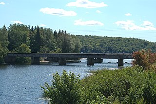
The Keweenaw Waterway is a partly natural, partly artificial waterway which cuts across the Keweenaw Peninsula of Michigan; it separates Copper Island from the mainland. Parts of the waterway are variously known as the Keweenaw Waterway, Portage Canal, Portage Lake Canal, Portage River, Lily Pond, Torch Lake, and Portage Lake. The waterway connects to Lake Superior at its north and south entries, with sections known as Portage Lake and Torch Lake in between. The primary tributary to Portage Lake is the Sturgeon River.

There are two streams named Salmon Trout River in the Upper Peninsula of the U.S. state of Michigan.

Eagle River is an unincorporated community and census-designated place in the U.S. state of Michigan and is the county seat of Keweenaw County. Its population was 71 as of the 2010 census. It is by far the least-populated county seat in the state of Michigan.
Black River is a 29.8-mile-long (48.0 km) river on the Upper Peninsula of the U.S. state of Michigan. The river flows into the Middle Branch Escanaba River in Ely Township of Marquette County at 46°23′53″N87°46′15″W and on into Lake Michigan.

The Brule River is a 52.3-mile-long (84.2 km) river in the U.S. states of Michigan and Wisconsin. Nearly the entire course forms a portion of the boundary between the two states.
Paint River is a 45.5-mile-long (73.2 km) river in the U.S. state of Michigan.
Osceola was an unincorporated community that existed in King County, Washington, around the turn of the 20th century, about two miles southeast of Enumclaw. Today not much remains except the last surviving one-room schoolhouse on the Enumclaw plateau; it is now the Osceola Community Club, a women's social club. The Osceola Mudflow that spread from nearby Mount Rainier approximately 5,000 years ago forms much of the Enumclaw plateau, and was named after the community.
The Graveraet River is an 8.7-mile-long (14.0 km) river in Houghton County on the Upper Peninsula of Michigan in the United States. It is a tributary of Lake Superior.
The Otter River is a 10.0-mile-long (16.1 km) river in Houghton County, Michigan, in the United States. It was home to the last known population of Michigan Grayling. No grayling have been seen or caught in the river since 1938.
The Perch River is a 25.4-mile-long (40.9 km) tributary of the Sturgeon River in Iron County and Baraga County on the Upper Peninsula of Michigan in the United States. The Perch River begins at the outlet of Perch Lake in Bates Township and flows north through Ottawa National Forest to the Sturgeon River.

The Peshekee River is a 31.1-mile-long (50.1 km) river on the Upper Peninsula of Michigan in the United States. It is a tributary of Lake Michigamme, and its waters flow via the Michigamme River and the Menominee River to Lake Michigan.

The Pilgrim River is a 12.9-mile-long (20.8 km) river in Portage Township, Houghton County, Michigan, in the United States. The river flows near the Portage Lake Golf Course and empties into the Keweenaw Waterway, which connects to Lake Superior.
The Sante River is an 8.7-mile-long (14.0 km) stream on the Upper Peninsula of Michigan in the United States. Via the North Branch Otter River, Otter River, Sturgeon River and Portage River, its waters flow to Lake Superior.
The Snake River is a 5.1-mile-long (8.2 km) tributary of the Portage River on the Upper Peninsula of Michigan in the United States. Via the Portage River, its water flows to Lake Superior.
The Traverse River is an 11.9-mile-long (19.2 km) river in Keweenaw and Houghton counties on the Upper Peninsula of Michigan in the United States. It flows into Lake Superior just north of Keweenaw Bay.
The Silver River is a 3.2-mile-long (5.1 km) stream near the northern tip of the Keweenaw Peninsula in the U.S. state of Michigan. It rises out of a marsh around Bailey Pond at 47°26′16″N88°03′08″W and flows mostly northward into Lake Superior at 47°28′05″N88°04′26″W.
The Silver River is a 24.9-mile-long (40.1 km) river in the U.S. state of Michigan. It rises from the outflow of Fisher Lake at 46°39′18″N88°14′06″W and flows in an arc to the northwest and then bending to northeast before emptying into Huron Bay of Lake Superior at 46°48′58″N88°17′45″W.
The Silver River is a 31.3-mile-long (50.4 km) stream in the Upper Peninsula in the U.S. state of Michigan.
The Spurr River is a short stream in the Upper Peninsula of the U.S. state of Michigan. It rises from the outflow of Beaufort Lake at 46°32′47″N88°11′14″W and flows 3.9 miles (6.3 km) east-southeast into Lake Michigamme at 46°31′43″N88°07′54″W.
The Pike River is an 11.6-mile-long (18.7 km) stream in Houghton County in the U.S. state of Michigan.


