
Tigard is a city in Washington County, Oregon, United States. The population was 54,539 at the 2020 census. As of 2007, Tigard was the state's 12th largest city. Incorporated in 1961, the city is located south of Beaverton and north of Tualatin, and is part of the Portland metropolitan area. Interstate 5 and Oregon Route 217 are the main freeways in the city, with Oregon Route 99W and Oregon Route 210 serving as other major highways. Public transit service is provided by TriMet, via several bus routes and the WES Commuter Rail line.

The Willamette River is a major tributary of the Columbia River, accounting for 12 to 15 percent of the Columbia's flow. The Willamette's main stem is 187 miles (301 km) long, lying entirely in northwestern Oregon in the United States. Flowing northward between the Oregon Coast Range and the Cascade Range, the river and its tributaries form the Willamette Valley, a basin that contains two-thirds of Oregon's population, including the state capital, Salem, and the state's largest city, Portland, which surrounds the Willamette's mouth at the Columbia.

Grand Ronde is a census-designated place (CDP) and unincorporated community in Polk and Yamhill counties, Oregon, United States. Historically noted as a village in Polk County, the sphere of influence and community is in both Polk and Yamhill counties. The name of the community is a variation of the French Grande Ronde or "Grand Round" which could be about the large round-up of Native American peoples in the area who were settled on what was known as the Grand Ronde Indian Reservation, or possibly referencing the shape of the valley in which the community is located. As of the census of 2010, there were 1,661 people in 658 households residing in Grand Ronde. It is part of the Salem Metropolitan Statistical Area.

The Santiam River is a tributary of the Willamette River, about 12 miles (19 km) long, in western Oregon in the United States. Through its two principal tributaries, the North Santiam and the South Santiam rivers, it drains a large area of the Cascade Range at the eastern side of the Willamette Valley east of Salem and Corvallis.

The Yamhill River is an 11-mile (18 km) tributary of the Willamette River, in the U.S. state of Oregon. Formed by the confluence of the South Yamhill River and the North Yamhill River about 3 miles (5 km) east of McMinnville, it drains part of the Northern Oregon Coast Range. The river meanders east past Dayton to join the Willamette River at its river mile (RM) 55 or river kilometer (RK) 89, south of Newberg.

The Kalapuya are a Native American people, which had eight independent groups speaking three mutually intelligible dialects. The Kalapuya tribes' traditional homelands were the Willamette Valley of present-day western Oregon in the United States, an area bounded by the Cascade Range to the east, the Oregon Coast Range at the west, the Columbia River at the north, to the Calapooya Mountains of the Umpqua River at the south.
Northern Kalapuyan is an extinct Kalapuyan language indigenous to northwestern Oregon in the United States. It was spoken by Kalapuya groups in the northern Willamette Valley southwest of present-day Portland.
Central Kalapuyan was a Kalapuyan language indigenous to the central and southern Willamette Valley in Oregon in the United States. It was spoken by various bands of the Kalapuya peoples who inhabited the valley up through the middle of the 19th century. The language is closely related to Northern Kalapuya, spoken in the Tualatin and Yamhill valleys. Dialects of Central Kalapuya that have been identified include:

The Willamette Falls is a natural waterfall on the Willamette River between Oregon City and West Linn, Oregon, in the United States. It is the largest waterfall in the Northwestern United States by volume, and the seventeenth widest in the world. Horseshoe in shape, it is 1,500 feet (460 m) wide and 40 feet (12 m) high with a flow of 30,849 cu ft/s, located 26 miles (42 km) upriver from the Willamette's mouth. Willamette Falls is a culturally significant site for many tribal communities in the region.
The AtfalatiIPA:[aˈtɸalati], also known as the Tualatin or Wapato Lake Indians are a tribe of the Kalapuya Native Americans who originally inhabited and continue to steward some 24 villages on the Tualatin Plains in the northwest part of the U.S. state of Oregon; the Atfalati also live in the hills around Forest Grove, along Wapato Lake and the north fork of the Yamhill River, and into areas of Southern Portland.
The Molala are a people of the Plateau culture area in the Oregon Cascades and central Oregon, United States. They are one of the Confederated Tribes of the Grand Ronde Community of Oregon, with 141 of the 882 members in the 1950s claiming Molala descent. The Confederated Tribes of Siletz Indians also has Molalla representation among its confederation of Tribes and Bands. The Siletz Reservation was established in 1855, for the Coast, Willamette and Umpqua Tribes. The Molalla are one of the Tribes who signed the 1855 Willamette Valley Treaty.

Kalapuyan is a small extinct language family that was spoken in the Willamette Valley of Western Oregon, United States. It consists of three languages.

The Confederated Tribes of the Grand Ronde Community of Oregon (CTGR) consists of twenty-seven Native American tribes with long historical ties to present-day western Oregon between the western boundary of the Oregon Coast and the eastern boundary of the Cascade Range, and the northern boundary of southwestern Washington and the southern boundary of northern California. The community has an 11,288-acre (45.7 km2) Indian reservation, the Grand Ronde Indian Reservation, which was established in 1855 in Yamhill and Polk counties.

The Klickitat are a Native American tribe of the Pacific Northwest. Today most Klickitat are enrolled in the federally recognized Confederated Tribes and Bands of the Yakama Nation, some are also part of the Confederated Tribes of the Grand Ronde Community of Oregon.

The Grand Ronde Community is an Indian reservation located on several non-contiguous sections of land in southwestern Yamhill County and northwestern Polk County, Oregon, United States, about 18 miles (29 km) east of Lincoln City, near the community of Grand Ronde. In the mid-19th century, the United States government forced various tribes and bands from all parts of Western Oregon to be removed from their homes and placed on this reservation. It is governed by the Confederated Tribes of the Grand Ronde Community of Oregon. The reservation has a land area of 16.384 square miles (42.43 km2). In the 2000 census recorded a population of 55 persons. Most members of the tribe live elsewhere in order to find work.

General Joel Palmer was an American pioneer of the Oregon Territory in the Pacific Northwest region of North America. He was born in Canada, and spent his early years in New York and Pennsylvania before serving as a member of the Indiana House of Representatives.
The Mohawk or Mohawk River people were a tribe or band of the Kalapuya, who originally lived in the Mohawk River area of present-day Oregon in the United States. They spoke a dialect of the Central Kalapuya language.
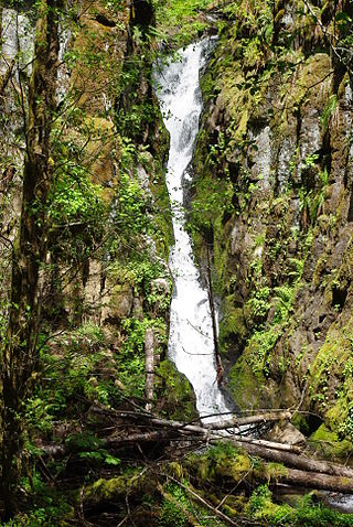
Ki-a-Kuts Falls is a 40-foot (12 m) tall waterfall on the Tualatin River in Washington County, Oregon, United States. Discovered in 1993 in the more remote upper stretch of the river, the falls were named after the last chief of the local band of Native Americans, Chief Ki-a-Kuts of the Atfalati. The water descends in a single fall down a narrow channel in the basalt cliffs overhanging the river at that spot.

The Willamette Valley is a 150-mile (240 km) long valley in Oregon, in the Pacific Northwest region of the United States. The Willamette River flows the entire length of the valley and is surrounded by mountains on three sides: the Cascade Range to the east, the Oregon Coast Range to the west, and the Calapooya Mountains to the south.
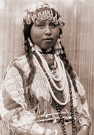
The Native American peoples of Oregon are the set of Indigenous peoples who have inhabited or who still inhabit the area delineated in today's state of Oregon in the Pacific Northwest region of the United States. While the state of Oregon currently maintains relations with nine federally recognized tribal groups, the state was previously home to a much larger number of autonomous tribal groups, which today either no longer exist or have been absorbed into these larger confederated entities. Six of the nine tribes gained federal recognition in the late 20th century, after undergoing the termination and restoration of their treaty rights starting in the 1950s.

