Trevorton, Pennsylvania

Last updated
Trevorton, Pennsylvania
CDP
Pennsylvania Route 225 in Trevorton 2.JPG
USA Pennsylvania location map.svg
Red pog.svg
Trevorton
Location within the U.S. state of Pennsylvania
Usa edcp location map.svg
Red pog.svg
Trevorton
Trevorton (the United States)
Coordinates: 40°46′53″N76°40′27″W / 40.78139°N 76.67417°W / 40.78139; -76.67417
Country United States
State Pennsylvania
County Northumberland
Area
[1]
  Total4.26 sq mi (11.04 km2)
  Land4.26 sq mi (11.04 km2)
  Water0.00 sq mi (0.00 km2)
Population
 (2020) [2]
  Total1,759
  Density412.72/sq mi (159.33/km2)
Time zone UTC-5 (Eastern (EST))
  Summer (DST) UTC-4 (EDT)
ZIP code
17881
Area code(s) 570 and 272
FIPS code 42-77448

Trevorton is a census-designated place (CDP) in Zerbe Township, Northumberland County, Pennsylvania, United States. The population was 1,834 at the 2010 census. [3]

Contents

Geography

Trevorton is located at 40°46′53″N76°40′27″W / 40.78139°N 76.67417°W / 40.78139; -76.67417 (40.781510, -76.674259). [4]

According to the United States Census Bureau, the CDP has a total area of 4.3 square miles (11 km2), all land.

The community is located at the junction of Routes 225 and 890.

Demographics

Historical population
CensusPop.Note
1950 2,545
1960 2,5972.0%
1970 2,196−15.4%
2000 2,010
2010 1,834−8.8%
2020 1,759−4.1%
U.S. Decennial Census [5] [6]

As of the 2000 census, [7] there were 2,010 people, 866 households, and 5690 families residing in Trevorton. The population density was 470.2 inhabitants per square mile (181.5/km2). There were 931 housing units at an average density of 217.8 per square mile (84.1/km2). The racial makeup of the CDP was 98.71% White, 0.15% African American, 0.05% Native American, 0.15% Asian, 0.15% from other races, and 0.80% from two or more races. Hispanic or Latino of any race were 0.40% of the population.

There were 866 households, out of which 25.2% had children under the age of 18 living with them, 52.5% were married couples living together, 8.3% had a female householder with no husband present, and 35.3% were non-families. 31.6% of all households were made up of individuals, and 16.5% had someone living alone who was 65 years of age or older. The average household size was 2.32 and the average family size was 2.91.

The population of Trevorton was spread out, with 21.1% under the age of 18, 7.1% from 18 to 24, 27.5% from 25 to 44, 23.9% from 45 to 64, and 20.4% who were 65 years of age or older. The median age was 42 years. For every 100 females there were 100.4 males. For every 100 females age 18 and over, there were 95.1 males.

The median income for a household in the CDP was $32,013, and the median income for a family was $38,143. Males had a median income of $30,236 versus $18,207 for females. The per capita income for the CDP was $15,781. About 6.0% of families and 8.6% of the population were below the poverty line, including 7.9% of those under age 18 and 13.5% of those age 65 or over.

Related Research Articles

<span class="mw-page-title-main">Brickerville, Pennsylvania</span> Census-designated place in Pennsylvania, United States

Brickerville is an unincorporated community and census-designated place (CDP) in Elizabeth Township, Lancaster County, Pennsylvania, United States, with a ZIP code of 17543. The population was 1,309 at the 2010 census.

<span class="mw-page-title-main">West Hurley, New York</span> CDP in New York, United States

West Hurley is a hamlet in Ulster County, New York, United States. The population was 1,917 at the 2020 census.

<span class="mw-page-title-main">Rupert, Pennsylvania</span> Census-designated place in Pennsylvania, United States

Rupert is a census-designated place (CDP) in Columbia County, Pennsylvania, United States. It is part of Northeastern Pennsylvania. The population was 154 at the 2020 census. It is part of the Bloomsburg-Berwick micropolitan area.

<span class="mw-page-title-main">Lawnton, Pennsylvania</span> Census-designated place in Pennsylvania, United States

Lawnton is an unincorporated area and census-designated place (CDP) in Swatara Township, Dauphin County, Pennsylvania, United States. The population was 3,813 at the 2010 census. It is part of the Harrisburg–Carlisle Metropolitan Statistical Area.

<span class="mw-page-title-main">Paxtonia, Pennsylvania</span> Census-designated place in Pennsylvania, United States

Paxtonia is an unincorporated community and census-designated place (CDP) in Lower Paxton Township, Dauphin County, Pennsylvania, United States. The population was 5,412 at the 2010 census. It is part of the Harrisburg–Carlisle Metropolitan Statistical Area.

Lebanon South is an unincorporated area and census-designated place (CDP) in Lebanon County, Pennsylvania, United States. The population was 2,270 at the 2010 census.

<span class="mw-page-title-main">Fairview-Ferndale, Pennsylvania</span> CDP in Pennsylvania, United States

Fairview-Ferndale is a census-designated place (CDP), located in Coal Township, in Northumberland County, Pennsylvania, United States. The population was 2,411 at the 2000 census.

<span class="mw-page-title-main">Marshallton, Pennsylvania</span> CDP in Pennsylvania, United States

Marshallton is a census-designated place (CDP), located in Coal Township, in Northumberland County, Pennsylvania, United States. The population was 1,441 at the 2010 census.

<span class="mw-page-title-main">Branchdale, Pennsylvania</span> CDP in Pennsylvania, United States

Branchdale is a census-designated place (CDP) in Schuylkill County, Pennsylvania, United States. The population was 436 at the 2000 census.

<span class="mw-page-title-main">Donaldson, Pennsylvania</span> CDP in Pennsylvania, United States

Donaldson is a census-designated place (CDP) in Frailey Township, Schuylkill County, Pennsylvania, United States. The population was 325 at the 2000 census.

Forestville is a census-designated place (CDP) in Schuylkill County, Pennsylvania, United States. The population was 431 at the 2000 census.

<span class="mw-page-title-main">Klingerstown, Pennsylvania</span> CDP in Pennsylvania, United States

Klingerstown is a census-designated place (CDP) in Upper Mahantongo Township, Schuylkill County, Pennsylvania, United States. As of the 2000 census, the CDP population was 102.

<span class="mw-page-title-main">Marlin, Pennsylvania</span> CDP in Pennsylvania, United States

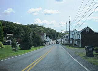
Marlin, or MarLin is a census-designated place (CDP) in Schuylkill County, Pennsylvania, United States. The population was 640 at the 2000 census. It is a village of Norwegian Township. The village is the seat of government for the township.

<span class="mw-page-title-main">Newtown, Schuylkill County, Pennsylvania</span> CDP in Pennsylvania, United States

Newtown is a census-designated place (CDP) in Reilly Township, Schuylkill County in the U.S. state of Pennsylvania. The population was 244 at the 2000 census.

<span class="mw-page-title-main">Shenandoah Heights, Pennsylvania</span> CDP in Pennsylvania, United States

Shenandoah Heights is a census-designated place (CDP) in Schuylkill County, Pennsylvania. The population was 1,298 at the 2000 census.

<span class="mw-page-title-main">Chapman Township, Snyder County, Pennsylvania</span> Township in Pennsylvania, United States

Chapman Township is a township in Snyder County, Pennsylvania, United States. The population was 1,565 at the 2020 census.

<span class="mw-page-title-main">Hummels Wharf, Pennsylvania</span> CDP in Pennsylvania, United States

Hummels Wharf is a census-designated place (CDP) in Snyder County, Pennsylvania, United States. The population was 641 at the 2000 census.

<span class="mw-page-title-main">Union Township, Snyder County, Pennsylvania</span> Township in Pennsylvania, United States

Union Township is a township in Snyder County, Pennsylvania, United States. The population was 1,493 at the 2020 census.

<span class="mw-page-title-main">Thompsonville, Pennsylvania</span> Census-designated place in Pennsylvania, United States

Thompsonville is a census-designated place (CDP) in Washington County, Pennsylvania, United States. The population was 3,520 at the 2010 census.

Duncott is a census-designated place (CDP) in Schuylkill County, Pennsylvania, United States, near Minersville in the Coal Region. The population was 76 at the 2000 census. It is located in Cass Township.

References

  1. "ArcGIS REST Services Directory". United States Census Bureau. Retrieved October 12, 2022.
  2. "Census Population API". United States Census Bureau. Retrieved Oct 12, 2022.
  3. "Trevorton, Pennsylvania (PA 17881) profile: population, maps, real estate, averages, homes, statistics, relocation, travel, jobs, hospitals, schools, crime, moving, houses, news, sex offenders". www.city-data.com.
  4. "US Gazetteer files: 2010, 2000, and 1990". United States Census Bureau. 2011-02-12. Retrieved 2011-04-23.
  5. "Census of Population and Housing". Census.gov. Retrieved June 4, 2016.
  6. "U.S. Census website". United States Census Bureau . Retrieved 2008-01-31.