Tropical Storm Choi-wan (2021)

Last updated

Map key
  Tropical depression (≤38 mph, ≤62 km/h)
  Tropical storm (39–73 mph, 63–118 km/h)
  Category 1 (74–95 mph, 119–153 km/h)
  Category 2 (96–110 mph, 154–177 km/h)
  Category 3 (111–129 mph, 178–208 km/h)
  Category 4 (130–156 mph, 209–251 km/h)
  Category 5 (≥157 mph, ≥252 km/h)
  Unknown
Storm type
Disc Plain black.svg Tropical cyclone
Solid black.svg Subtropical cyclone
ArrowUp.svg Extratropical cyclone, remnant low, tropical disturbance, or monsoon depression

On May 27, the Japan Meteorological Agency (JMA) and the Joint Typhoon Warning Center (JTWC) noted the persistence of an area of atmospheric convection about 425 nautical miles (787 km; 489 mi) south-southeast of Guam. [5] The convection's nearby environment exhibited low vertical wind shear and warm 29–30 °C (84–86 °F) sea surface temperatures; ideal conditions for tropical cyclogenesis. [6] The JMA assessed the area of convection to have developed into a tropical depression on May 29 at 06:00 UTC around 06°N136°E / 6°N 136°E / 6; 136 . [7] The PAGASA made a similar assessment in a Tropical Cyclone Advisory issued at 15:00 UTC. [8] The JTWC later followed with their own assessment, identifying the center of the newly developed tropical depression approximately 35 nautical miles (65 km; 40 mi) south-southeast of Angaur, Palau and assigning the designation 04W. [9] As the system tracked westward, it entered the Philippine Area of Responsibility at 01:00 PHT (17:00 UTC). [10] The PAGASA then named the storm Dante in its first Tropical Cyclone Bulletin for the storm. [11]

Choi-wan intensified further in the Philippine Sea and the JTWC had determined that the depression strengthened into a tropical storm. [12] [13] Later on, the Japan Meteorological Agency also upgraded the system into a tropical storm, and the storm was then named Choi-wan. [14] Choi-wan's center was exposed due to a tropical upper tropospheric trough from the northeast, inducing shear on the system. [15] The system continued to move northwestward before taking a west-northwestward track while continuing to struggle from moderate shear. [16] At 20:30 PHT (01:30 UTC), Choi-wan struck Sulat, Eastern Samar as a minimal tropical storm. [17] Midway through its transit through the Philippines, the JTWC then downgraded it into a tropical depression. [18] [16]

It then made a second landfall on the municipality of Cataingan on the island of Masbate at 17:00 UTC on June 1 [19] before it made another landfall in Balud at 19:30 UTC, still in the province. [20] It traversed the Sibuyan Sea then made a fourth landfall in the island of Romblon, Romblon at 00:00 UTC on the next day. [20] It crossed the Romblon Pass before making a fifth landfall in the municipality of San Agustin, fifty minutes after the previous one, still in the province. [20] Choi-wan then headed northwest while struggling to reorganize under the waters of the Tablas Strait, and then making a sixth landfall in Pola, Oriental Mindoro at 06:00 UTC. [20] It traversed the island of Mindoro with the system being disorganized again before exiting into the Verde Island Passage. Choi-wan then made a seventh landfall in Marincaban Island, Tingloy, Batangas at 11:20 UTC. [20] Continuing to move northwestward, the system made an eighth and final landfall in the Calatagan Peninsula in Batangas at 12:00 UTC on June 2 before exiting back into the South China Sea. [21] Despite the system being predicted to dissipate in the area, warm sea surface temperatures aided Choi-wan to restrengthen to a tropical storm at 03:00 UTC on the next day. [22]

A large high-pressure area in the central Pacific Ocean and an anticyclone over China turned the system north-northeastward, with the storm exiting the Philippine Area of Responsibility at 18:00 UTC. [23] Dry air yet again impacted the storm, with Choi-wan's convection being displaced to the west as it approached Taiwan and as a result, the storm weakened again to a tropical depression per the estimates of the JTWC[ citation needed ] and the PAGASA. [24] At 08:00 UTC on June 4, Choi-wan reentered the PAR before the system started to merge with an existing meiyu front which extends from China to the Japanese Islands [25] and at the same time, passing to the south of Taiwan. [26] At 1:00 UTC, the system re-exited the PAR for the second and final time [25] as it headed north-northeastward.[ citation needed ] While passing through the Ryukyu Islands, the JMA issued their final warning on Choi-wan as it transitioned to an extratropical storm [27] as it was still embedded in the front.[ citation needed ]

Preparations and impact

Philippines

As Choi-wan (known locally as Dante) approached the Philippines, Tropical Cyclone Warning Signal (TCWS) #1 was issued in most of Luzon, the Visayas and Mindanao on May 31. [28] The next day, as Dante came closer to landfall, TCWS #2 was issued across a stretch of the eastern Philippines extending northward from Biliran and Samar to Quezon. [29] Before the landfalls of Choi-wan, the NDRRMC conducted a risk assessment for the approaching storm on May 31 while over 1.105 billion worth of standby funds were dispersed by the country's Social Welfare and Development department for the evacuees. [30] The Philippine Institute of Volcanology and Seismology (PHIVOLCS), in the other hand, issued an advisory for possible lahar on June 1 for the Mayon Volcano. [31] At least 604 people were forced to take shelter in evacuation centers in Davao City. [32] Elsewhere, classes were suspended and workplaces closed in Sorsogon on June 1 and 2. [33] 500 families in Agusan del Norte were forced to flee their homes as flash floods swept across the region. [34] A total of 45,000 people were impacted in the southwestern Philippines, while 12,000 were safely evacuated. [2] In Western Visayas, 895 people were evacuated on June 2. [3] Within Negros Occidental, sea travel was suspended and citizens reported flooding. [35] A preemptive evacuation were ordered on Albay's landslide, flood and lahar-prone areas on the same day. [36] The province of Ilocos Norte in Northern Luzon were placed on heightened alert, also on the same day, following Choi-wan's approach as the storm progressed in the South China Sea. [37]

In Mindanao, heavy rains caused flash floods and landslides from May 29 to June 1, affecting at least 2,642 people and destroying crops. [38] [32] Floods killed a girl and left her father missing in South Cotabato, and drowned a man in Davao del Sur. A landslide killed a baby in Davao de Oro. [32] Damage to agriculture in Mindanao was valued at 14.6 million (US$305,000). [39] A pick-up truck was swept up by floods and both of its two passengers were left missing, although they were later found alive with the truck being damaged beyond recognition. [35] Around 4,813 citizens were displaced in Agusan del Norte from Choi-wan. [4] Choi-wan caused 307.2 million in damage (US$6.39 million) to infrastructure and in the agricultural industry across both Visayas and Mindanao throughout its path on June 1–2. [40] Choi-wan later scraped the coastline of Batangas Province in Luzon, causing minimal impact, before exiting into the coastal waters near Oriental Mindoro. [41] 2 people, a 28-year-old man and 32-year-old woman, died in Oriental Mindoro after being struck by lightning, the man dying immediately and the woman dying on arrival to the hospital due to her injuries. [42] A 19-year-old teen died in Occidental Mindoro after also being struck by lightning in San Jose. [43] 11 people in total died across the Philippines, while at least 2 are still missing as of June 6. [1]

Taiwan

The Central Weather Bureau of Taiwan issued land wind warnings across the country on June 3 as Choi-wan approached the country from the southwest. [44] Heavy rain alerts were also issued for 15 counties as Choi-wan interacted with a front which was also delivering rainfall to the country. [44] Roads in Greater Taipei were flooded and became impassable, while trees collapsed under the dampened soil. [45] 234 mm (9.2 in) of rain fell in Taipei within just three hours, while an estimated 300 mm (12 in) of rain fell near the National Taiwan University. [45] The districts of Daan, Wenshan, Nangang, Neihu, and Xinyi in Taipei all reported over 100 mm (3.9 in) of rain due to the combination of the frontal system and Choi-wan, according to Taipei Mayor Ko Wen-je. [46] Wind warnings related to Choi-wan were lifted on June 4 as the storm weakened to a tropical depression, although rain warnings remained in effect as the unrelated frontal system continued to produce heavy rainfall. [26]

See also

Related Research Articles

<span class="mw-page-title-main">2005 Pacific typhoon season</span> Typhoon season in the Western Pacific Ocean

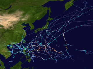
The 2005 Pacific typhoon season was the least active typhoon season since 2000, producing 23 named storms, of which 13 became typhoons. It was an event in the annual cycle of tropical cyclone formation, in which tropical cyclones form in the western Pacific Ocean. The season ran throughout 2005, though most tropical cyclones typically develop between May and October. The season's first named storm, Kulap, developed on January 13, while the season's last named storm, Bolaven, dissipated on November 20. The season's first typhoon, Haitang, reached typhoon status on July 13, and became the first super typhoon of the year three days later.

<span class="mw-page-title-main">Timeline of the 2008 Pacific typhoon season</span>

This timeline documents all the storm formations, strengthening, weakening, landfalls, extratropical transitions, as well as dissipation during the 2008 Pacific typhoon season. The 2008 Pacific typhoon season officially started on January 1, 2008 and ended on January 1, 2009. The first tropical cyclone of the season formed on January 13. The timeline also includes information which was not operationally released, meaning that information from post-storm reviews by the various warning agencies, such as information on a storm that was not operationally warned on, has been included.

<span class="mw-page-title-main">2009 Pacific typhoon season</span> Typhoon season in the Western Pacific Ocean

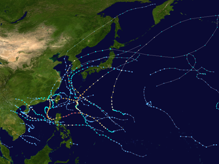
The 2009 Pacific typhoon season was a below average season that spawned only 22 named storms, 13 typhoons, and five super typhoons. It was also recognized as the deadliest season in the Philippines for decades. The first half of the season was very quiet whereas the second half of the season was extremely active. The season's first named storm, Kujira, developed on May 3 while the season's last named storm, Nida, dissipated on December 3.

<span class="mw-page-title-main">Timeline of the 2009 Pacific typhoon season</span>

This timeline documents all of the events of the 2009 Pacific typhoon season which was the period that tropical cyclones formed in the Western Pacific Ocean during 2009, with most of the tropical cyclones forming between May and November. The scope of this article is limited to the Pacific Ocean, north of the equator between 100°E and the International Date Line. Tropical storms that form in the entire Western Pacific basin are assigned a name by the Japan Meteorological Agency. Tropical depressions that form in this basin are given a number with a "W" suffix by the United States' Joint Typhoon Warning Center. In addition, the Philippine Atmospheric, Geophysical and Astronomical Services Administration (PAGASA) assigns names to tropical cyclones that enter or form in the Philippine area of responsibility. These names, however, are not in common use outside of the Philippines.

<span class="mw-page-title-main">2017 Pacific typhoon season</span> Typhoon season in the Western Pacific Ocean

The 2017 Pacific typhoon season was a below-average season in terms of accumulated cyclone energy and the number of typhoons and super typhoons, and the first since the 1977 season to not produce a Category 5-equivalent typhoon on the Saffir–Simpson scale. The season produced a total of 27 named storms, 11 typhoons, and only two super typhoons, making it an average season in terms of storm numbers. It was an event in the annual cycle of tropical cyclone formation, in which tropical cyclones form in the western Pacific Ocean. The season runs throughout 2017, though most tropical cyclones typically develop between May and October. The season's first named storm, Muifa, developed on April 25, while the season's last named storm, Tembin, dissipated on December 26. This season also featured the latest occurrence of the first typhoon of the year since 1998, with Noru reaching this intensity on July 23.

<span class="mw-page-title-main">2018 Pacific typhoon season</span> Typhoon season in the Western Pacific Ocean

The 2018 Pacific typhoon season was at the time, the costliest Pacific typhoon season on record, until the record was beaten by the following year. The season was well above-average, producing twenty-nine storms, thirteen typhoons, seven super typhoons and six Category 5 tropical cyclones. The season ran throughout 2018, though most tropical cyclones typically develop between May and October. The season's first named storm, Bolaven, developed on January 3, while the season's last named storm, Man-yi, dissipated on November 28. The season's first typhoon, Jelawat, reached typhoon status on March 29, and became the first super typhoon of the year on the next day.

<span class="mw-page-title-main">Timeline of the 2010 Pacific typhoon season</span>

This timeline documents all of the events of the 2010 Pacific typhoon season. Most of the tropical cyclones forming between May and November. The scope of this article is limited to the Pacific Ocean, north of the equator between 100°E and the International Date Line. Tropical storms that form in the entire Western Pacific basin are assigned a name by the Japan Meteorological Agency. Tropical depressions that form in this basin are given a number with a "W" suffix by the United States' Joint Typhoon Warning Center. In addition, the Philippine Atmospheric, Geophysical and Astronomical Services Administration (PAGASA) assigns names to tropical cyclones that enter or form in the Philippine area of responsibility. These names, however, are not in common use outside of the Philippines.

<span class="mw-page-title-main">2020 Pacific typhoon season</span> Typhoon season in the Western Pacific Ocean

The 2020 Pacific typhoon season was the first with below-average tropical cyclone activity since 2017, with 23 named storms, 10 of which became typhoons and only 2 became super typhoons. This low activity was a consequence of La Niña that persisted from the summer of the year. It had the fifth-latest start in the basin on record, slightly behind 1973, and was the first to start that late since 2016. The first half of the season was unusually inactive, with only four systems, two named storms and one typhoon at the end of July. Additionally, the JTWC recorded no tropical cyclone development in the month of July, the first such occurrence since reliable records began. The season's first named tropical cyclone, Vongfong, developed on May 8, while the season's last named tropical cyclone, Krovanh, dissipated on December 24. However, the season's last system was an unnamed tropical depression which dissipated on December 29.

<span class="mw-page-title-main">Timeline of the 2015 Pacific typhoon season</span>

This timeline documents all of the events of the 2015 Pacific typhoon season. Most of the tropical cyclones formed between May and November. The scope of this article is limited to the Pacific Ocean, north of the equator between 100°E and the International Date Line. This area, called the Western Pacific basin, is the responsibility of the Japanese Meteorological Agency (JMA). They host and operate the Regional Specialized Meteorological Center (RSMC), located in Tokyo. The Japanese Meteorological Agency (JMA) is also responsible for assigning names to all tropical storms that are formed within the basin. However, any storm that enters or forms in the Philippine Area of Responsibility (PAR) will be named by the Philippine Atmospheric, Geophysical and Astronomical Services Administration (PAGASA) using a local name. Also of note - the Western Pacific basin is monitored by the United States' Joint Typhoon Warning Center (JTWC), which gives all Tropical depressions a number with a "W" suffix.

<span class="mw-page-title-main">Tropical Storm Kujira (2015)</span> 2015 Pacific tropical storm

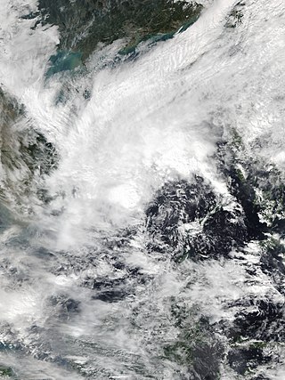
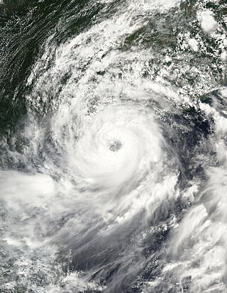
Tropical Storm Kujira was a tropical cyclone that prompted the PAGASA to declare the beginning of the rainy season in the Philippines. The ninth tropical depression, 8th named storm, and first storm to make landfall on China in the 2015 Pacific typhoon season, it formed as a tropical depression south of the Paracel Islands on June 19.

<span class="mw-page-title-main">2021 Pacific typhoon season</span> Typhoon season in the Western Pacific Ocean

The 2021 Pacific typhoon season was the second consecutive to have below-average tropical cyclone activity, with twenty-two named storms, and was the least active since 2011. Nine became typhoons, and five of those intensified into super typhoons. This low activity was caused by a strong La Niña that had persisted from the previous year. The season's first named storm, Dujuan, developed on February 16, while the last named storm, Rai, dissipated on December 21. The season's first typhoon, Surigae, reached typhoon status on April 16. It became the first super typhoon of the year on the next day, also becoming the strongest tropical cyclone in 2021. Surigae was also the most powerful tropical cyclone on record in the Northern Hemisphere for the month of April. Typhoons In-fa and Rai are responsible for more than half of the total damage this season, adding up to a combined total of $2.02 billion.

<span class="mw-page-title-main">2022 Pacific typhoon season</span> Typhoon season in the Western Pacific Ocean

The 2022 Pacific typhoon season was the third consecutive season to have below-average tropical cyclone activity, with twenty-five named storms forming. Of the tropical storms, ten became typhoons, and three would intensify into super typhoons. The season saw a slightly below average activity by named storm count, although many of the storms were weak and short-lived, particularly towards the end of the season. This low activity was caused by an unusually strong La Niña that had persisted from 2020. The season's first named storm, Malakas, developed on April 6, while the last named storm, Pakhar, dissipated on December 12. The season's first typhoon, Malakas, reached typhoon status on April 12. The season ran throughout 2022, though most tropical cyclones typically develop between May and October. Tropical storms Megi and Nalgae were responsible for more than half of the casualties, while typhoons Hinnamnor and Nanmadol both caused $1 billion in damages.

<span class="mw-page-title-main">Typhoon Maggie</span> Pacific typhoon in 1999

Typhoon Maggie, known in the Philippines as Typhoon Etang, was a large and powerful typhoon that affected the Philippines and southeast Asia. The sixth tropical cyclone and second typhoon of the 1999 Pacific typhoon season, Maggie developed from a monsoon trough over the Philippine Sea on June 1. Quickly intensifying to tropical storm strength the following day, Maggie followed a northward course as it continued to intensify, reaching typhoon strength at 18:00 UTC as it turned northwestward. Maggie rapidly intensified to reach its peak intensity as a Category 3 equivalent typhoon on June 5 as it passed through the Luzon Strait. The typhoon brushed Taiwan on June 6 and began to weaken, making landfall near Hong Kong as a minimal typhoon on June 7. Afterward, Maggie weakened to a tropical storm as it briefly moved offshore. The storm moved back onshore the following day and quickly weakened, degenerating into a remnant area of low pressure on June 8.

<span class="mw-page-title-main">Tropical Storm Merbok (2017)</span> Pacific severe tropical storm in 2017

Severe Tropical Storm Merbok was a weak tropical cyclone that brought significant impacts to southern China in June 2017. Merbok developed out of a tropical depression which was first monitored by the JMA while it was west of Manila, Philippines, on June 10. The system would later be named 04W by the JTWC. The depression then strengthened into Tropical Storm Merbok before making landfall in eastern Shenzhen, China. Merbok would rapidly weaken inland, dissipating over Southern China on June 13.

<span class="mw-page-title-main">Tropical Storm Krovanh (2020)</span> Pacific tropical storm in 2020

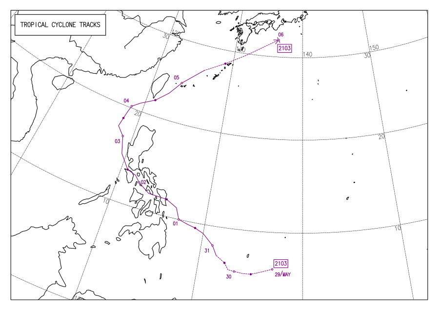
Tropical Storm Krovanh, known in the Philippines as Tropical Depression Vicky, was a tropical cyclone which caused deadly flooding in the Philippines during December 2020. The 31st depression and 23rd and final named storm of the 2020 Pacific typhoon season, Krovanh originated from a tropical depression which was first monitored by PAGASA, late on December 17. The system strengthened with PAGASA naming it Vicky, meanwhile the JMA monitored it as a low pressure area. The depression then made several landfalls over the Philippines on December 18–19 before moving out of the PAR on December 20, as it strengthened into a tropical storm according to the JMA and was named Krovanh. However, Krovanh was downgraded back to a tropical depression the next day, with the JTWC issuing their final advisory on December 22.

<span class="mw-page-title-main">Typhoon Toraji (2001)</span> Western Pacific typhoon in 2001

Typhoon Toraji, known in the Philippines as Typhoon Isang, was one of the deadliest tropical cyclones to hit the island country of Taiwan, since 1961. The eight named storm and the third typhoon of the 2001 Pacific typhoon season, Toraji's origins were from an area of convection that persisted to the west of Guam. Moving north-northwest over favorable conditions, the disturbance intensified to a tropical depression, while the JTWC issued a TCFA on the newly developed system. On July 26, the depression entered the Philippine Area of Responsibility, with the PAGASA naming it Isang. Strong easterly wind shear inhibited further development; however, as the shear relaxed, both the JTWC and PAGASA upgraded the system to a tropical storm with also the JMA following suit hours later. Now named Toraji, the storm slowly intensified, reaching typhoon status on the next day. Toraji continued to gain strength until it made landfall as a Category 2 typhoon near Taipei on July 29. Despite the rugged terrains of the country, the JTWC upgraded the system further to a Category 3, shortly before weakening as it moved offshore on Taiwan Strait. The JMA and PAGASA downgraded the typhoon to a tropical storm, with the latter issuing their final advisory as it moved out of their AOR. It continued to weaken, with the JTWC also downgrading the system to a tropical storm, before making landfall near Fuzhou on July 31 before it was last noted by the next day.

<span class="mw-page-title-main">Tropical Storm Kirogi (2017)</span> Pacific tropical storm in 2017

Tropical Storm Kirogi, known in the Philippines as Tropical Storm Tino, was a weak tropical cyclone that affected the Philippines and Vietnam. The thirty-ninth tropical depression, twenty-fifth tropical storm, and fourteenth system to affect Vietnam in the 2017 Pacific typhoon season, Kirogi formed as a tropical depression on November 16 in the Moro Gulf. After being given the local name Tino by the PAGASA, it entered the South China Sea, intensifying into a tropical storm and receiving the name Kirogi from the Japan Meteorological Agency on November 18. Continuing westwards, it weakened into a tropical depression before making landfall near Cam Ranh Bay in Vietnam on the next day, dissipating shortly afterwards. Kirogi's remnants later contributed to the formation of Cyclone Ockhi.

<span class="mw-page-title-main">Tropical Storm Conson (2021)</span> Pacific severe tropical storm in 2021

Severe Tropical Storm Conson, known in the Philippines as Typhoon Jolina, was a strong tropical cyclone that impacted the central Philippines and Vietnam during the 2021 Pacific typhoon season. Being the thirteenth named storm of the said event, Conson originated as a low-pressure area first monitored approximately 500 km (310 mi) west of Guam. It formed as a tropical depression over the Pacific Ocean on September 5, 2021. As it formed within the Philippine Area of Responsibility, the Philippine Atmospheric, Geophysical, and Astronomical Services Administration (PAGASA) named the storm Jolina. Over the next day, it intensified into a tropical storm and was named Conson by the Japan Meteorological Agency (JMA). As the storm neared Samar Island, it intensified into a severe tropical storm, and later into a typhoon according to the PAGASA prior to its first landfall in Eastern Samar. The storm retained its strength as it crossed Visayas and later Calabarzon before weakening over Manila Bay prior to its final landfall in Bataan. It subsequently emerged into the South China Sea where it struggled to reintensify further. It then weakened into a tropical depression just offshore of Vietnam before moving ashore near Da Nang. It then rapidly weakened before dissipating on September 13.

<span class="mw-page-title-main">Typhoon Chaba (2022)</span> Pacific typhoon in 2022

Typhoon Chaba, known in the Philippines as Tropical Depression Caloy was a Category 1-equivalent typhoon that struck South China after affecting the Philippines as a tropical depression. The third named storm and second typhoon of the 2022 Pacific typhoon season, Chaba originated from a low-pressure area west of Luzon and developed into a tropical depression on June 28. Chaba made landfall in southwestern Guangdong province, China; at least 12 people died when an offshore crane vessel split in half during the storm and sank.

<span class="mw-page-title-main">Tropical Storm Talim (2023)</span> Pacific tropical storm in 2023

Severe Tropical Storm Talim, known in the Philippines as Tropical Storm Dodong, was a compact tropical cyclone that affected the Philippines, China, and Vietnam. The fourth named storm of the 2023 Pacific typhoon season, Talim originated from a weak monsoon depression east of Manila while moving towards Luzon. The system continued to track westward close to the northern edge of mainland Luzon before emerging off the coast of Ilocos Norte. A favorable environment allowed the fledgling tropical storm to rapidly intensify to a Category 2-equivalent typhoon on the Saffir–Simpson scale. The storm maintained this intensity until shortly before landfall near Zhanjiang, Guangdong on July 17. Talim quickly weakened and dissipated early on July 18.

References

  1. 1 2 SitRep no.06 re Preparedness Measures and Effects of ITCZ enhanced by TS DANTE (PDF) (Report). National Disaster Risk Reduction and Management Council. June 6, 2021. Archived from the original (PDF) on June 6, 2021. Retrieved June 6, 2021.
  2. 1 2 Diaz, Jaclyn (June 2, 2021). "Storm Hits The Philippines, Leaving At Least 3 Dead And Hundreds Displaced". NPR.org. Archived from the original on June 10, 2021. Retrieved June 4, 2021.
  3. 1 2 Lena, Perla. "4 missing, 895 evacuated in W. Visayas due to 'Dante'". www.pna.gov.ph. Archived from the original on June 4, 2021. Retrieved June 4, 2021.
  4. 1 2 Lopez, Alexander. "'Dante' displaces over 1.5K families in Agusan Norte, Butuan". www.pna.gov.ph. Archived from the original on June 5, 2021. Retrieved June 4, 2021.
  5. "WWJP27 RJTD 270600". Archived from the original on May 29, 2021. Retrieved May 31, 2021.
  6. Significant Tropical Weather Advisory for the Western and South Pacific Oceans (Report). United States Joint Typhoon Warning Center. May 27, 2021. Archived from the original on April 25, 2021. Retrieved May 27, 2021.PD-icon.svg This article incorporates text from this source, which is in the public domain .
  7. "WWJP27 RJTD 290600". Japan Meteorological Agency. May 29, 2021. Archived from the original on May 29, 2021. Retrieved May 29, 2021.
  8. "Tropical Cyclone Advisory #1 for Tropical Depression" (PDF). PAGASA . May 29, 2021. Archived from the original (PDF) on May 29, 2021. Retrieved May 29, 2021. Alt URL
  9. Tropical Depression 04W (Four) Warning No. 1 (Report). United States Joint Typhoon Warning Center. May 29, 2021. Archived from the original on May 29, 2021. Retrieved May 29, 2021. Alt URL
  10. PAGASA-DOST [@dost_pagasa] (May 29, 2021). "TROPICAL CYCLONE UPDATE - 3:15 AM, May 30, 2021 - At 1:00 AM today, the Tropical Depression east of Mindanao entered the Philippine Area of Responsibility and was named "DANTE". Tropical Cyclone Bulletins will be issued beginning at 5:00 AM today" (Tweet) via Twitter.
  11. "Tropical Cyclone Bulletin #1 for Tropical Depression 'Dante'" (PDF). PAGASA . May 29, 2021. Archived from the original (PDF) on April 3, 2015. Retrieved May 29, 2021. Alt URL
  12. "Tropical Cyclone Bulletin #6 for Tropical Storm 'Dante' (Choi-wan)" (PDF). PAGASA . May 31, 2021. Archived from the original (PDF) on April 3, 2015. Retrieved May 31, 2021. Alt URL
  13. Tropical Storm 04W (Four) Warning No. 4 (Report). United States Joint Typhoon Warning Center. May 30, 2021. Archived from the original on May 29, 2021. Retrieved May 30, 2021. Alt URL
  14. "WTPQ30 RJTD 310000". National Oceanic and Atmospheric Administration . Japan Meteorological Agency. May 31, 2021. Archived from the original on May 31, 2021. Retrieved June 1, 2021.
  15. Prognostic Reasoning for Tropical Storm 04W (Four) Warning No. 6 (Report). United States Joint Typhoon Warning Center. May 31, 2021. Archived from the original on May 29, 2021. Retrieved May 31, 2021. Alt URL
  16. 1 2 Prognostic Reasoning for Tropical Depression 04W (Four) Warning No. 12 (Report). United States Joint Typhoon Warning Center. June 1, 2021. Archived from the original on May 29, 2021. Retrieved June 1, 2021. Alt URL
  17. "Tropical Cyclone Bulletin #15 for Tropical Storm 'Dante' (Choi-wan)" (PDF). PAGASA . May 31, 2021. Archived from the original (PDF) on May 30, 2021. Retrieved May 31, 2021. Alt URL
  18. Tropical Depression 04W (Four) Warning No. 12 (Report). United States Joint Typhoon Warning Center. June 1, 2021. Archived from the original on May 29, 2021. Retrieved June 1, 2021. Alt URL
  19. "Tropical Cyclone Bulletin #16 for Tropical Storm 'Dante' (Choi-wan)" (PDF). PAGASA . May 31, 2021. Archived from the original (PDF) on May 30, 2021. Retrieved May 31, 2021. Alt URL
  20. 1 2 3 4 5 Sitrep No. 04 re Preparedness Measures and Effects of Intertropical Convergence Zone (ITCZ) enhanced by Tropical Storm "Dante" (I.N. Choi-wan) (PDF) (Report). National Disaster Risk Reduction and Management Council. June 4, 2021. Archived from the original (PDF) on June 4, 2021. Retrieved June 4, 2021.
  21. Arceo, Acor (June 2, 2021). "Tropical Storm Dante makes 7th, 8th landfalls in Batangas". Rappler. Archived from the original on June 10, 2021. Retrieved June 3, 2021.
  22. "Tropical Storm 04W (Choi-wan) Warning NR 018". Joint Typhoon Warning Center . June 3, 2021. Archived from the original on June 3, 2021. Retrieved June 3, 2021 via National Oceanic and Atmospheric Administration.
  23. Arceo, Acor (June 4, 2021). "Tropical Storm Dante exits PAR but may reenter". Rappler . Archived from the original on June 10, 2021. Retrieved June 5, 2021.
  24. Arceo, Acor (June 5, 2021). "Dante weakens into tropical depression, reenters PAR". Rappler . Archived from the original on June 10, 2021. Retrieved June 5, 2021.
  25. 1 2 Arceo, Acor (June 5, 2021). "Dante leaves PAR for 2nd time". Rappler . Archived from the original on June 10, 2021. Retrieved June 5, 2021.
  26. 1 2 "Warning lifted after Choi-Wan downgraded to tropical depression - Focus Taiwan". focustaiwan.tw (in Chinese). Archived from the original on June 10, 2021. Retrieved June 4, 2021.
  27. "Extratropical Cyclone (T2103 CHOI-WAN)". Japan Meteorological Agency. Archived from the original on June 5, 2021. Retrieved June 5, 2021.
  28. "SitRep No. 01 re Preparedness Measures and Effects of Intertropical Convergence Zone (ITCZ) enhanced by Tropical Storm "DANTE" (I.N. CHOI-WAN)" (PDF). National Disaster Risk Reduction and Management Council. June 1, 2021. Archived from the original (PDF) on June 2, 2021. Retrieved June 2, 2021.
  29. Arceo, Acor (June 2, 2021). "Tropical Storm Dante heads for Romblon after 2nd landfall in Masbate". Rappler . Archived from the original on June 10, 2021. Retrieved June 5, 2021.
  30. Parrocha, Azer (June 2, 2021). "Palace calls for vigilance as Tropical Storm Dante hits PH". Philippine News Agency . Archived from the original on June 5, 2021. Retrieved June 5, 2021.
  31. "LAHAR ADVISORY FOR MAYON VOLCANO UNDER TROPICAL STORM DANTE (CHOI-WAN): 1 June 2021 6:00 PM". PHIVOLCS . June 1, 2021. Archived from the original on June 5, 2021. Retrieved June 5, 2021.
  32. 1 2 3 Ferrariz, Mariel B. (May 31, 2021). DSWD DROMIC Report #1 on Tropical Storm "Dante" (Report). Department of Social Welfare and Development Disaster Response Operations Monitoring and Information Center. Archived from the original on June 2, 2021. Retrieved June 1, 2021.
  33. Mier-Manjares, Maria April (June 2, 2021). "Classes, work suspended in Sorsogon due to 'Dante'". Philippine Daily Inquirer. Archived from the original on June 2, 2021. Retrieved June 2, 2021.
  34. Enano, Erwin M. Mascariñas, Jhesset O. (June 2, 2021). "Agusan del Norte folk flee homes as Tropical Storm Dante triggers floods". INQUIRER.net. Archived from the original on June 4, 2021. Retrieved June 4, 2021.{{cite web}}: CS1 maint: multiple names: authors list (link)
  35. 1 2 Ellera, Teresa D. (June 3, 2021). "TS Dante affects Negros Occidental". Sunstar. Archived from the original on June 3, 2021. Retrieved June 4, 2021.
  36. Mascarinas, Erwin M.; Enano, Jhesset O. (June 2, 2021). "Agusan del Norte folk flee homes as Tropical Storm Dante triggers floods". Philippine Daily Inquirer . Archived from the original on June 4, 2021. Retrieved June 5, 2021.
  37. Adriano, Leilanie (June 2, 2021). "Ilocos Norte on heightened alert due to 'Dante'". Philippine News Agency . Archived from the original on June 5, 2021. Retrieved June 5, 2021.
  38. Davies, Richard (June 1, 2021). "Philippines – Tropical Storm 'Choi-Wan' (Dante) Triggers Deadly Flash Floods and Evacuations". FloodList. Archived from the original on June 1, 2021. Retrieved June 2, 2021.
  39. "Dante leaves 3 dead, nearly P15 million worth of damage in agriculture". ABS-CBN News. June 2, 2021. Archived from the original on June 2, 2021. Retrieved June 2, 2021.
  40. "SitRep no.10 re Preparedness Measures and Effects of ITCZ enhanced by TS DANTE" (PDF). NDRRMC. Retrieved June 11, 2021.[ permanent dead link ]
  41. "'Dante' nicks Batangas on exit path". Manila Standard. Archived from the original on December 23, 2021. Retrieved June 4, 2021.
  42. Virola, Madonna T. (June 3, 2021). "Lightning kills 2 in Mindoro at height of storm 'Dante'". INQUIRER.net. Archived from the original on June 4, 2021. Retrieved June 4, 2021.
  43. "Lightning kills teen in Occidental Mindoro amid Dante's onslaught —OCD Mimaropa". GMA News Online. Archived from the original on June 4, 2021. Retrieved June 4, 2021.
  44. 1 2 "Taiwan issues land warning for Tropical Storm Choi-Wan - Focus Taiwan". focustaiwan.tw (in Chinese). Archived from the original on June 3, 2021. Retrieved June 4, 2021.
  45. 1 2 Charlier, Phillip (June 4, 2021). "Northern Taiwan pelted with rain: flood warnings issued for Greater Taipei". Taiwan English News. Archived from the original on June 4, 2021. Retrieved June 4, 2021.
  46. "Afternoon downpour causes flooding in parts of Taipei - Focus Taiwan". focustaiwan.tw (in Chinese). Archived from the original on June 4, 2021. Retrieved June 4, 2021.
Tropical Storm Choi-wan (Dante)
Choi-wan 2021-06-01 0510Z.jpg
Tropical Storm Choi-wan nearing landfall in Eastern Samar on June 1