Trough (meteorology)

Last updated
Representation of alternating troughs and ridges in upper-level westerlies for the Northern Hemisphere, with regions of convergence and divergence labeled. Trough.jpg
Representation of alternating troughs and ridges in upper-level westerlies for the Northern Hemisphere, with regions of convergence and divergence labeled.

A trough is an elongated region of relatively low atmospheric pressure without a closed isobaric contour that would define it as a low pressure area. Since low pressure implies a low height on a pressure surface, troughs and ridges refer to features in an identical sense as those on a topographic map.

Contents

Troughs may be at the surface, or aloft, at altitude. Near-surface troughs sometimes mark a weather front associated with clouds, showers, and a wind direction shift. Upper-level troughs in the jet stream (as shown in diagram) reflect cyclonic filaments of vorticity. Their motion induces upper-level wind divergence, lifting and cooling the air ahead (downstream) of the trough and helping to produce cloudy and rain conditions there.

Unlike fronts, there is not a universal symbol for a trough on a surface weather analysis chart. The weather charts in some countries or regions mark troughs by a line. In the United States, a trough may be marked as a dashed line or bold line. In the UK, Hong Kong [1] and Fiji, [2] it is represented by a bold line extended from a low pressure center [3] or between two low pressure centers; [4] in Macau [5] and Australia, [6] it is a dashed line. If they are not marked, troughs may still be identified as an extension of isobars away from a low pressure center.

Description

A very large trough (about 8000 km or more) crosses the North Atlantic Ocean from north east to south west. The elongated cloud is surrounded by two big areas of higher atmospheric pressure, clearly shown with no clouds at all. Nov-12-2012-7am.gif
A very large trough (about 8000 km or more) crosses the North Atlantic Ocean from north east to south west. The elongated cloud is surrounded by two big areas of higher atmospheric pressure, clearly shown with no clouds at all.

A trough is an elongated area of lower air pressure. Since pressure is closely linked to wind, there are often changes in wind direction across a trough.

If a trough forms in the mid-latitudes, a temperature difference at some distance between the two sides of the trough usually exists and the trough might become a weather front at some point. However, such a weather front is usually less convective than a trough in the tropics or subtropics (such as a tropical wave). Inversely, sometimes collapsed frontal systems will degenerate into troughs.

Sometimes the region between two high pressure centers may also assume the character of a trough when there is a detectable wind shift noted at the surface. In the absence of a wind shift, the region is designated a col, akin to a geographic saddle between two mountain peaks.

Formation

A trough is the result of the movements of the air in the atmosphere. In regions where there is upward movement near the ground and divergence at altitude, there is a loss of mass. The pressure becomes lower at this point.

At upper levels of the atmosphere, this occurs when there is a meeting of a mass of cold air and another hot one along a thin ribbon called a frontal baroclinic zone. We then have the creation of a jet stream that plunges the cold air towards the equator and hot air towards the poles, creating a ripple in the circulation that is called a Rossby wave. [7] These undulations give the hollows and peaks of altitude. In general, absolute vorticity advection is positive between these two features, but closer to the ridge, whereas it is negative just behind a trough.

At the surface, lifting air under positive vorticity advection is reflected by the formation of depressions and troughs. There will therefore be a slope between the barometric high altitude and that on the ground, this slope going towards the mass of cold air at high altitude (generally towards the Pole).

Positively/negatively tilted

Troughs have an orientation relative to the poles which is rarely North-South. In the Northern Hemisphere, positively tilted troughs will extend from the lowest pressure northeast to southwest while negatively tilted troughs have a northwest to southeast orientation. [8] In the Southern Hemisphere, the positive tilt will be southeast to northwest and the negative one southwest to northeast.

A trough will usually begin with a positive tilt as cold air moves toward the Equator. [8] The trough will become neutral (North-South) and then negatively tilted as the energy carried by the cold air races east through the atmospheric circulation and distorts its shape. [8] The positive tilt is thus the building phase of the trough and the negative tilt is the dissipation of its energy. Therefore, the clouds and precipitation will develop in the positive phase and the most severe weather will be in the negative phase. [8]

Types of trough

In addition to standard troughs, some troughs may be described further with a qualifying term indicating a specific or a set of characteristics.

Inverted trough

An inverted trough is an atmospheric trough which is oriented opposite to most troughs of the mid-latitudes. Most (but not all) inverted troughs are tropical waves (also commonly called easterly waves).

Most troughs of low pressure in the mid-latitudes of the Northern Hemisphere are characterized by decreasing atmospheric pressure from south to north while inverted troughs are characterized by decreasing pressure from north to south. This situation is the opposite in the Southern Hemisphere. Inverted troughs in both hemispheres move to the west from the east, while mid-latitude troughs generally move with the westerlies toward the east.

Lee trough

A lee trough, also known as a dynamic trough, is "A pressure trough formed on the lee side of a mountain range in situations where the wind is blowing with a substantial component across the mountain ridge; often seen on United States weather maps east of the Rocky Mountains, and sometimes east of the Appalachians, where it is less pronounced." [9] It can be formed either as a result of the adiabatic compression of sinking air on the lee side of a mountain range, or through cyclogenesis resulting from "the horizontal convergence associated with vertical stretching of air columns passing over the ridge and descending the lee slope." [9] [10]

Weather associated

Convective cells may develop in the vicinity of troughs and give birth to a tropical cyclone. Some tropical or subtropical regions such as the Philippines or south China are greatly affected by convection cells along a trough.

In the mid-latitude westerlies, upper level troughs and ridges often alternate in a high-amplitude pattern. For a trough in the westerlies, the region just west of the trough axis is typically an area of convergent winds and descending air – and hence high pressure –, while the region just east of the trough axis is an area of fast, divergent winds and low pressure. Tropical waves are a type of trough in easterly currents, a cyclonic northward deflection of the trade winds.

See also

Related Research Articles

<span class="mw-page-title-main">Jet stream</span> Fast-flowing atmospheric air current

Jet streams are fast flowing, narrow, meandering air currents in the atmospheres of the Earth, Venus, Jupiter, Saturn, Uranus, and Neptune. On Earth, the main jet streams are located near the altitude of the tropopause and are westerly winds. Jet streams may start, stop, split into two or more parts, combine into one stream, or flow in various directions including opposite to the direction of the remainder of the jet.

<span class="mw-page-title-main">Cyclone</span> Large scale air mass that rotates around a strong center of low pressure

In meteorology, a cyclone is a large air mass that rotates around a strong center of low atmospheric pressure, counterclockwise in the Northern Hemisphere and clockwise in the Southern Hemisphere as viewed from above. Cyclones are characterized by inward-spiraling winds that rotate about a zone of low pressure. The largest low-pressure systems are polar vortices and extratropical cyclones of the largest scale. Warm-core cyclones such as tropical cyclones and subtropical cyclones also lie within the synoptic scale. Mesocyclones, tornadoes, and dust devils lie within the smaller mesoscale.

<span class="mw-page-title-main">Tropopause</span> The boundary of the atmosphere between the troposphere and stratosphere

The tropopause is the atmospheric boundary that demarcates the troposphere from the stratosphere, which are the lowest two of the five layers of the atmosphere of Earth. The tropopause is a thermodynamic gradient-stratification layer that marks the end of the troposphere, and is approximately 17 kilometres (11 mi) above the equatorial regions, and approximately 9 kilometres (5.6 mi) above the polar regions.

<span class="mw-page-title-main">Anticyclone</span> Weather phenomenon of high pressure, as opposed to a cyclone

An anticyclone is a weather phenomenon defined as a large-scale circulation of winds around a central region of high atmospheric pressure, clockwise in the Northern Hemisphere and counterclockwise in the Southern Hemisphere as viewed from above. Effects of surface-based anticyclones include clearing skies as well as cooler, drier air. Fog can also form overnight within a region of higher pressure.

<span class="mw-page-title-main">Intertropical Convergence Zone</span> Meteorological phenomenon

The Intertropical Convergence Zone, known by sailors as the doldrums or the calms because of its monotonous windless weather, is the area where the northeast and the southeast trade winds converge. It encircles Earth near the thermal equator though its specific position varies seasonally. When it lies near the geographic Equator, it is called the near-equatorial trough. Where the ITCZ is drawn into and merges with a monsoonal circulation, it is sometimes referred to as a monsoon trough.

<span class="mw-page-title-main">Atmospheric circulation</span> Process which distributes thermal energy about the Earths surface

Atmospheric circulation is the large-scale movement of air and together with ocean circulation is the means by which thermal energy is redistributed on the surface of the Earth. The Earth's atmospheric circulation varies from year to year, but the large-scale structure of its circulation remains fairly constant. The smaller-scale weather systems – mid-latitude depressions, or tropical convective cells – occur chaotically, and long-range weather predictions of those cannot be made beyond ten days in practice, or a month in theory.

<span class="mw-page-title-main">High-pressure area</span> Region with higher atmospheric pressure

A high-pressure area, high, or anticyclone, is an area near the surface of a planet where the atmospheric pressure is greater than the pressure in the surrounding regions. Highs are middle-scale meteorological features that result from interplays between the relatively larger-scale dynamics of an entire planet's atmospheric circulation.

<span class="mw-page-title-main">Low-pressure area</span> Area with air pressures lower than adjacent areas

In meteorology, a low-pressure area, low area or low is a region where the atmospheric pressure is lower than that of surrounding locations. Low-pressure areas are commonly associated with inclement weather, while high-pressure areas are associated with lighter winds and clear skies. Winds circle anti-clockwise around lows in the northern hemisphere, and clockwise in the southern hemisphere, due to opposing Coriolis forces. Low-pressure systems form under areas of wind divergence that occur in the upper levels of the atmosphere (aloft). The formation process of a low-pressure area is known as cyclogenesis. In meteorology, atmospheric divergence aloft occurs in two kinds of places:

<span class="mw-page-title-main">Westerlies</span> Prevailing winds from the west

The westerlies, anti-trades, or prevailing westerlies, are prevailing winds from the west toward the east in the middle latitudes between 30 and 60 degrees latitude. They originate from the high-pressure areas in the horse latitudes and trend towards the poles and steer extratropical cyclones in this general manner. Tropical cyclones which cross the subtropical ridge axis into the westerlies recurve due to the increased westerly flow. The winds are predominantly from the southwest in the Northern Hemisphere and from the northwest in the Southern Hemisphere.

<span class="mw-page-title-main">Cyclogenesis</span> The development or strengthening of cyclonic circulation in the atmosphere

Cyclogenesis is the development or strengthening of cyclonic circulation in the atmosphere. Cyclogenesis is an umbrella term for at least three different processes, all of which result in the development of some sort of cyclone, and at any size from the microscale to the synoptic scale.

<span class="mw-page-title-main">Pressure system</span> Relative peak or lull in the sea level pressure distribution

A pressure system is a peak or lull in the sea level pressure distribution. The surface pressure at sea level varies minimally, with the lowest value measured 87 kilopascals (26 inHg) and the highest recorded 108.57 kilopascals (32.06 inHg). High- and low-pressure systems evolve due to interactions of temperature differentials in the atmosphere, temperature differences between the atmosphere and water within oceans and lakes, the influence of upper-level disturbances, as well as the amount of solar heating or radiationized cooling an area receives. Pressure systems cause weather to be experienced locally. Low-pressure systems are associated with clouds and precipitation that minimize temperature changes throughout the day, whereas high-pressure systems normally associate with dry weather and mostly clear skies with larger diurnal temperature changes due to greater radiation at night and greater sunshine during the day. Pressure systems are analyzed by those in the field of meteorology within surface weather maps.

<span class="mw-page-title-main">Mesoscale convective system</span> Complex of thunderstorms organized on a larger scale

A mesoscale convective system (MCS) is a complex of thunderstorms that becomes organized on a scale larger than the individual thunderstorms but smaller than extratropical cyclones, and normally persists for several hours or more. A mesoscale convective system's overall cloud and precipitation pattern may be round or linear in shape, and include weather systems such as tropical cyclones, squall lines, lake-effect snow events, polar lows, and mesoscale convective complexes (MCCs), and generally forms near weather fronts. The type that forms during the warm season over land has been noted across North and South America, Europe, and Asia, with a maximum in activity noted during the late afternoon and evening hours.

<span class="mw-page-title-main">Ridge (meteorology)</span> Elongated region of high atmospheric pressure

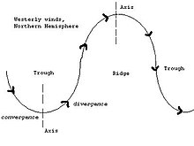
In meteorology a ridge or barometric ridge is an elongated area of relatively high atmospheric pressure compared to the surrounding environment, without being a closed circulation. It is associated with an area of maximum anticyclonic curvature of wind flow. The ridge originates in the center of an anticyclone and sandwiched between two low-pressure areas, and the locus of the maximum curvature is called the ridge line. This phenomenon is the opposite of a trough.

<span class="mw-page-title-main">Tropical cyclogenesis</span> Development and strengthening of a tropical cyclone in the atmosphere

Tropical cyclogenesis is the development and strengthening of a tropical cyclone in the atmosphere. The mechanisms through which tropical cyclogenesis occurs are distinctly different from those through which temperate cyclogenesis occurs. Tropical cyclogenesis involves the development of a warm-core cyclone, due to significant convection in a favorable atmospheric environment.

<span class="mw-page-title-main">Extratropical cyclone</span> Type of cyclone

Extratropical cyclones, sometimes called mid-latitude cyclones or wave cyclones, are low-pressure areas which, along with the anticyclones of high-pressure areas, drive the weather over much of the Earth. Extratropical cyclones are capable of producing anything from cloudiness and mild showers to severe gales, thunderstorms, blizzards, and tornadoes. These types of cyclones are defined as large scale (synoptic) low pressure weather systems that occur in the middle latitudes of the Earth. In contrast with tropical cyclones, extratropical cyclones produce rapid changes in temperature and dew point along broad lines, called weather fronts, about the center of the cyclone.

<span class="mw-page-title-main">Pacific–North American teleconnection pattern</span> Large-scale weather pattern with two modes

The Pacific–North American teleconnection pattern (PNA) is a large-scale weather pattern with two modes, denoted positive and negative, and which relates the atmospheric circulation pattern over the North Pacific Ocean with the one over the North American continent. It is the second leading mode of natural climate variability in the higher latitudes of the Northern Hemisphere and can be diagnosed using the arrangement of anomalous geopotential heights or air pressures over the North Pacific and North America.

<span class="mw-page-title-main">Upper tropospheric cyclonic vortex</span>

An upper tropospheric cyclonic vortex is a vortex, or a circulation with a definable center, that usually moves slowly from east-northeast to west-southwest and is prevalent across Northern Hemisphere's warm season. Its circulations generally do not extend below 6,080 metres (19,950 ft) in altitude, as it is an example of a cold-core low. A weak inverted wave in the easterlies is generally found beneath it, and it may also be associated with broad areas of high-level clouds. Downward development results in an increase of cumulus clouds and the appearance of circulation at ground level. In rare cases, a warm-core cyclone can develop in its associated convective activity, resulting in a tropical cyclone and a weakening and southwest movement of the nearby upper tropospheric cyclonic vortex. Symbiotic relationships can exist between tropical cyclones and the upper level lows in their wake, with the two systems occasionally leading to their mutual strengthening. When they move over land during the warm season, an increase in monsoon rains occurs.

<span class="mw-page-title-main">Cold-core low</span> Cyclone with an associated cold pool of air at high altitude

A cold-core low, also known as an upper level low or cold-core cyclone, is a cyclone aloft which has an associated cold pool of air residing at high altitude within the Earth's troposphere, without a frontal structure. It is a low pressure system that strengthens with height in accordance with the thermal wind relationship. If a weak surface circulation forms in response to such a feature at subtropical latitudes of the eastern north Pacific or north Indian oceans, it is called a subtropical cyclone. Cloud cover and rainfall mainly occurs with these systems during the day.

The following is a glossary of tornado terms. It includes scientific as well as selected informal terminology.

<span class="mw-page-title-main">Glossary of meteorology</span> List of definitions of terms and concepts commonly used in meteorology

This glossary of meteorology is a list of terms and concepts relevant to meteorology and atmospheric science, their sub-disciplines, and related fields.

References

  1. The Hong Kong Observatory, Weather Map at 08 HKT Archived 2008-07-03 at the Wayback Machine
  2. "Archived copy". Archived from the original on 2007-09-27. Retrieved 2006-05-28.{{cite web}}: CS1 maint: archived copy as title (link)
  3. "Archived copy". Archived from the original on 2005-10-31. Retrieved 2005-10-13.{{cite web}}: CS1 maint: archived copy as title (link)
  4. "Archived copy". Archived from the original on 2005-10-31. Retrieved 2005-10-13.{{cite web}}: CS1 maint: archived copy as title (link)
  5. Weather Chart Archived 2005-08-29 at the Wayback Machine
  6. "Latest Colour Mean Sea-Level Pressure Analysis". www.bom.gov.au. Archived from the original on 12 March 2018. Retrieved 30 April 2018.
  7. "Long and Short Waves". JetStream. National Weather Service . Retrieved July 29, 2018.
  8. 1 2 3 4 "Basic Wave Patterns". JetStream. National Weather Service . Retrieved July 29, 2018.
  9. 1 2 "Lee trough". Glossary of Meteorology (2nd ed.). American Meteorological Society. 25 April 2012. Archived from the original on 5 March 2017. Retrieved 2017-03-05.
  10. Jeff Haby. "What is a Lee-side Trough (Low)?". TheWeatherPrediction.com. Archived from the original on 2012-02-06. Retrieved 2006-10-30.