
Fluvanna County is a county located in the Piedmont region of the Commonwealth of Virginia, United States. As of the 2020 census, the population was 27,249. Its county seat is Palmyra, while the most populous community is the census designated place of Lake Monticello.

Bon Air is a census-designated place (CDP) in Chesterfield County, Virginia, United States. The population was 18,022 at the 2020 census. The community is considered a suburb of the independent city of Richmond in the Richmond-Petersburg region and is a part of the Southside neighborhoods. Originally developed as a resort, a central portion of Bon Air has been designated as a National Historic District with many structures of Victorian design from the late 19th and early 20th centuries. Its name means "good air," reflecting its role as a resort getaway that wealthy Richmonders enjoyed for its fresh air as opposed to the dirty air of Richmond's industrial downtown of the late 19th century.
Claiborne is an unincorporated community in Talbot County, Maryland, United States. The village is located on the eastern shore of the Chesapeake Bay near the mouth of the Eastern Bay at 38°50′15″N76°16′40″W, and uses ZIP code 21624. The 2000 U.S. Census listed the population as 147 and the number of homes as 84, slightly down from its 1941 population of 156. Between 1890 and 1930, the village was a busy port for passenger and then automobile ferry service across the Chesapeake Bay, with numerous stores and motels/resorts, including Maple Hall and the Bellfonte Hotel. A post office was added in 1893 and the Protestant Episcopal Church of Claiborne was built in 1898. In 1912, an elementary school and Methodist Church were added. Before 1912, students attended school in nearby McDaniel. The town's first school consisted of the kitchen of the local railroad pavilion, used as a classroom. In 1913, the town became home to the Claiborne Fresh Air Association, Inc., which was formed for the purpose of providing 10 weeks of fresh air and summer vacation for children who had been exposed to tuberculosis. The role of Claiborne as a terminal for cross-Bay ferries was diminished in 1930 when the primary route shifted to Matapeake in Kent Island. It ended altogether in 1938 when the direct connection from Annapolis to Claiborne was terminated and only an auxiliary shuttle between Claiborne and Romancoke on Kent Island remained. This shuttle service ended in 1952, a few months after the opening of the Chesapeake Bay Bridge; thus ending all ferry service to Claiborne after more than six decades.

Bower's Hill is a community located in the independent city of Chesapeake, Virginia in the United States. It is located in the South Hampton Roads region at the northeastern edge of the Great Dismal Swamp, an area consisting of generally low-lying sandy terrain of the coastal plain.
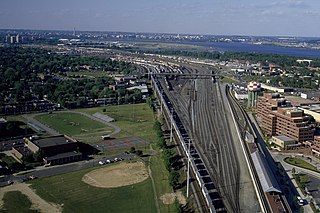
Potomac Yard is a neighborhood in Northern Virginia that straddles southeastern Arlington County and northeastern Alexandria, Virginia, located principally in the area between U.S. Route 1 and the Washington Metro Blue Line /Yellow Line tracks, or the George Washington Memorial Parkway, depending on the definition used. The area was home to what was once one of the busiest rail yards on the Eastern Seaboard of the United States. The "Potomac Yard" name is also used to refer to several developments in the area, especially the Potomac Yard Center power center and a Washington Metro station.
Buckingham Branch Railroad is a Class III short-line railroad operating over 275 miles (443 km) of historic and strategic trackage in Central Virginia. Sharing overhead traffic with CSX and Amtrak, the company's headquarters are in Dillwyn, Virginia in the former Chesapeake and Ohio Railway (C&O) station, itself a historic landmark in the community. The railroad was featured in the January 2012 issue of Trains Magazine. It is referenced in the How It’s Made episode “Railway Bridge Ties”, showing it crossing a curved bridge.

Bremo Bluff is an unincorporated community located on the northern bank of the James River in Fluvanna County, Virginia, United States. The locale was established by the Cocke family in 1636. During the American Civil War, the family of General Robert E. Lee sought refuge in the community. It is home to Bremo Power Station, which, at one point, generated 3 percent of the total electricity delivered by utility company Dominion Energy.
Virginia Air Line Railroad (VAL) was a short-line railroad that operated from 1908 to 1975 in Central Virginia. It was built by the Virginia Air Line Railway Company to connect the Chesapeake and Ohio Railway's (C&O) Piedmont Subdivision at Lindsay, Virginia, to the Rivanna Subdivision of C&O's James River Line at Strathmore Yard, near Bremo Bluff, Virginia.

The Norfolk Southern Railway was the final name of a railroad that ran from Norfolk, Virginia, southwest and west to Charlotte, North Carolina. It was acquired by the Southern Railway in 1974, which merged with the Norfolk and Western Railway in 1982 to form the current Norfolk Southern Railway.

The Norfolk and Portsmouth Belt Line Railroad is a class III railroad operating in southern Virginia.
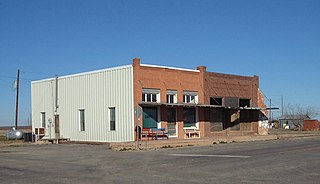
Fluvanna is an unincorporated community in Scurry County, Texas, United States. It lies just south of the Llano Estacado, high atop the caprock, where Farm to Market Road 1269 and Farm to Market Road 612 intersect.

U.S. Route 15 (US 15) is a part of the United States Numbered Highway System that runs from Walterboro, South Carolina, to Painted Post, New York. In Virginia, the U.S. Highway runs 230.37 miles (370.74 km) from the North Carolina state line near Clarksville north to the Maryland state line at the Potomac River near Lucketts. US 15 is a major north–south highway through the Piedmont of Virginia, connecting Clarksville and Farmville in Southside with Culpeper, Warrenton, and Leesburg in Northern Virginia.

Palmyra is a census-designated place (CDP) in and the county seat of Fluvanna County, Virginia, United States. The population as of the 2010 census was 104. Palmyra lies on the eastern bank of the Rivanna River along U.S. Route 15. The ZIP code for Palmyra and surrounding rural land is 22963.
Seaford is an unincorporated community in York County, Virginia, United States, on the Virginia Peninsula. As of the 2010 Census, the Seaford postal area had a population of 3,669.
Zion Crossroads is an unincorporated community in Louisa and Fluvanna counties of Virginia. It is at the intersections of James Madison Highway and Three Notch Road. Interstate 64 in Virginia passes one-half mile to the northeast.
Winifrede is an unincorporated community in Kanawha County, West Virginia, United States. Winifrede is 2.5 miles (4.0 km) southwest of Chesapeake. Winifrede has a post office with ZIP code 25214. It is home of the Big Eagle Railroad, one of the oldest short-line railroad operations in the United States, having been in existence since 1850. The Winifrede Railroad was incorporated in November 1881 and opened in 1882; the original operation was closed in 1988 and reopened as the Big Eagle Railroad in 2000–01.
Jodie, also known as Imboden, is an unincorporated community in Fayette County, West Virginia, United States. It is located along the Gauley River at the mouth of Rich Creek, 4 miles (6.4 km) northeast of Gauley Bridge. Due to its proximity to the county line, Jodie is part of the Nicholas County ZIP code of 26690; it had its own post office until its closure on July 23, 2005.
Fluvanna Correctional Center for Women is a prison operated by the Virginia Department of Corrections. It has a Troy postal address, and is in unincorporated Fluvanna County, about 55 miles (89 km) northwest of Richmond. The security level 3 facility housed 1,199 female inmates as of June 2008, including formerly housing the women's death row for the Commonwealth of Virginia.
Carysbrook is an unincorporated community in Fluvanna County, in the U.S. state of Virginia.
Cohasset is an unincorporated community in Fluvanna County, in the U.S. state of Virginia located about two miles west of Fork Union on State Route 6.


