Trump Street

Last updated

Trump Street, looking west from the junction with Lawrence Lane, January 2018 Trump Street, London, January 2018 09.jpg
Trump Street, looking west from the junction with Lawrence Lane, January 2018

Trump Street is a street in the City of London that was originally known as Trumpadere Street, probably after the trumpet or horn makers who once worked there or in the adjacent Trump Alley (now demolished). It was built after the Great Fire of London (1666) but completely destroyed by bombing during the Second World War and has since been entirely rebuilt.

Contents

Location

Vicinity of Trump Street Russia Row & Trump Street map.jpg
Vicinity of Trump Street

Trump Street runs between Russia Row and King Street. [1] The pedestrianised Honey Lane runs from the south side to join it to Cheapside. It is crossed only by Lawrence Lane. [2]

Trump Street on Richard Horwood's 1799 map, with Honey Lane Market where Russia Row is now Honey Lane Market on Richard Horwood's 1799 map.jpg
Trump Street on Richard Horwood's 1799 map, with Honey Lane Market where Russia Row is now

Freeman's Court, originally known as Trump Alley, once ran between Lawrence Lane and Honey Lane immediately to the south of and parallel with Trump Street. [3]

Origins

Trump Street, originally known as Trumpadere Street, [4] was built after the Great Fire of London in 1666. John Strype called it Duke Street in 1720. [5]

The street may be named after Trump Alley [6] or named because its occupants had the same occupation as those that lived in the alley. Henry Riley writes in his Memorials of the inscription on the coffin of Godefrey le Trompour and of trumpeters generally that:

The persons who followed this trade mostly lived, in all probability, in Trump Street, formerly Trump Alley (a much longer street then than it now is), near the Guildhall; their principal customers not improbably being the City waits, or watchmen; each of whom was provided with a trumpet, also known as a "wait," for sounding the hours of the watch, and giving the alarm. In reference to this trade it deserves remark, that the only memorial that has come down to us of the Chapel of St. Mary the Virgin, and of St. Mary Magdalen and All Saints, formerly adjoining the Guildhall, is a massive stone coffin (now in the Library at Guildhall), with its lid, whereon is sculptured a cross between two trumpets, and around its margin the following inscription:-Godefrey le Trompour : gist : ci : Deu : del : ealme : eit : merci. "Godefrey the Trompour lies here, God on the soul have mercy." In Trump Alley, close adjoining, he probably lived, sold trumpets, and died;—if we may judge from the character of the writing, in the latter half of the 14th century. [7]

Henry Harben considered that Riley was wrong to believe that Trump Alley and Trump Street were synonymous. [6]

Trump Street was recorded by the cartographer John Rocque in 1746, [6] and The London Encyclopaedia write that it "probably derived from a nearby Tavern, the Trumpeter Inn". [8] It appears on Richard Horwood's original (1799) and revised (1813) map of London with Honey Lane Market at its western end where Russia Row is now. [9]

Buildings

A tavern known as Blossom's Inn once stood on the north side of the street on a large site on the corner with Lawrence Lane from the fourteenth century until 1855. In the 1750s it became the London base for James Pickford, founder of the Pickfords removal firm. Archaeological excavations on the site in 2001 recovered Roman remains. [10] The site became a parcels depot for the Great Eastern Railway in the nineteenth century before being renamed Blossom's Inn again in the twentieth century. [2]

The street was completely destroyed by German bombing on 29 December 1940 during the Second World War and has since been rebuilt. [4]

City Tavern, Trump Street, now demolished City Tavern, City, EC2 (4103256760).jpg
City Tavern, Trump Street, now demolished

Today it is completely made up of office buildings with some retail premises at street level. The City Tavern, a post-Second World War pub which once stood on the south side on the corner with Lawrence Lane has been replaced with offices. Opposite, still on the south side, is King's House (36–37 King Street). The north side, east of Lawrence Lane, is 35 King Street. [2] The north side west of Lawrence Lane is an office building of 386,000 square feet (35,900 m2) [11] known as 30 Gresham Street that was developed by Land Securities in 2002–2003 and was described at the time as "the biggest speculative office development in the capital". [12]

Related Research Articles

<span class="mw-page-title-main">Fleet Street</span> Street in London

Fleet Street is a major street mostly in the City of London. It runs west to east from Temple Bar at the boundary with the City of Westminster to Ludgate Circus at the site of the London Wall and the River Fleet from which the street was named.

<span class="mw-page-title-main">St Lawrence Jewry</span> Church in London, England

St Lawrence Jewry next Guildhall is a Church of England guild church in the City of London on Gresham Street, next to Guildhall. It was destroyed in the Great Fire of London in 1666, and rebuilt to the designs of Sir Christopher Wren. It is the official church of the Lord Mayor of London.

<span class="mw-page-title-main">Gresham Street</span>

Gresham Street in the City of London is named after the English merchant and financier Thomas Gresham.

<span class="mw-page-title-main">All Hallows Honey Lane</span> Church in City of London, England

All Hallows, Honey Lane was a parish church in the City of London, England. Of medieval origin, it was destroyed in the Great Fire of London in 1666 and not rebuilt; the site became part of Honey Lane Market, which was in turn partially cleared to make way for the City of London School in the 19th century. Much of the area was destroyed during the bombing in World War II and has been redeveloped. The name Honey Lane is retained in a nearby walkway.

<span class="mw-page-title-main">Chancery Lane</span> London street in the ward of Farringdon Without

Chancery Lane is a one-way street situated in the ward of Farringdon Without in the City of London. It has formed the western boundary of the City since 1994, having previously been divided between the City of Westminster and the London Borough of Camden. The route originated as a 'new lane' created by the Knights Templar from their original 'old Temple' on the site of the present Southampton Buildings on Holborn, in order to access to their newly acquired property to the south of Fleet Street sometime before 1161.

<span class="mw-page-title-main">Fore Street, London</span> Street in the City of London, England

Fore Street is a street in the City of London near the Barbican Centre. It runs from Wood Street to Fore Street Avenue and is joined by Moor Lane on its north side. The street was extensively damaged by Nazi bombing during World War II and, following later development, nothing now remains of its original buildings other than St Giles-without-Cripplegate, which is a short distance away from the modern street.

<span class="mw-page-title-main">Essex Street, London</span>

Essex Street is a street in the City of Westminster that runs from Milford Lane in the south to Strand in the north. It is joined by Little Essex Street on its western side and Devereux Court on the eastern side. It was laid out by Nicholas Barbon in around 1675 or 1680 and contains a number of listed buildings.

<span class="mw-page-title-main">Milford Lane</span>

Milford Lane is a narrow street in the City of Westminster that runs from Strand in the north to a brief walkway section leading to Temple Place in the south. It is joined by Little Essex Street and Essex Street on its eastern side. Maltravers Street once joined the lane to Arundel Street, but ceased to exist when building work at 190 Strand was completed.

This is a list of the etymology of street names in the City of London.

<span class="mw-page-title-main">Russia Row</span>

Russia Row is a street in the City of London that runs between Milk Street and Trump Street on the northern side of the former Honey Lane Market. Russia Court, formerly Robin Hood Court, the home of the Russia Company, was once located on the northern side of the street and the City of London School on the south side. The street is thought to have received its name around 1804, shortly before Russia decided to enter the Napoleonic Wars on the same side as Britain. It was damaged by German bombing during the Second World War and has since been completely rebuilt.

<span class="mw-page-title-main">Blossom's Inn</span> Staging post

Blossom's Inn was a tavern which stood in Lawrence Lane in the City of London from the 14th century until 1855. It became a substantial coaching inn and was used as a staging post by carriers of goods. In the 19th century, the lease was bought and it became the parcel depot of the Great Eastern Railway. Its name was used for a major property development at the end of the 20th century and the site is now part of the large complex of 30 Gresham Street.

<span class="mw-page-title-main">Lawrence Lane, London</span>

Lawrence Lane is a street in the City of London that runs from Trump Street in the south to Gresham Street in the north. Its final section in the north is pedestrianised. An alley also joins it to King Street in the north. It once ran south to join Cheapside but that end was blocked following post-Second World War rebuilding. It was known as St Lawrence Lane from the 13th to the 18th centuries due to its proximity to the church of St Lawrence Jewry and until King Street was built was the main route from Cheapside to the London Guildhall.

<span class="mw-page-title-main">30 Gresham Street</span>

30 Gresham Street is an office building in Gresham Street in the City of London of 386,000 sq ft developed by Land Securities in 2002-03 and occupied by Commerzbank and Investec. When built, it was described as "the biggest speculative office development in the capital". The building is bounded in the south by Russia Row and Trump Street, in the east by Lawrence Lane, and in the west by Milk Street. It is on the site of the former Blossom's Inn as well as a number of other small alleys and courts such as Robin Hood Court, Russia Court, Mumford Court and Castle Court.

<span class="mw-page-title-main">Swan with Two Necks, London</span>

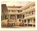
The Swan with Two Necks was a coaching inn in the City of London that, until the arrival of the railways, was one of the principal departure points for travel to the north of England from London. Its site was given over in the early 1860s to a goods and parcels depot for a firm of railway agents and carriers.

<span class="mw-page-title-main">Bull and Mouth Inn</span>

The Bull and Mouth Inn was a coaching inn in the City of London that dated from before the Great Fire of London in 1666. It was located between Bull and Mouth Street in the north and Angel Street in the south. It was once an important arrival and departure point for coaches from all over Britain, but particularly for the north of England and Scotland. It became the Queen's Hotel in 1830 but was demolished in 1887 or 1888 when new post office buildings were built in St Martin's Le Grand.

<span class="mw-page-title-main">Bull and Mouth Street</span>

Bull and Mouth Street was a street in the City of London that ran between Edward Street and St Martin's Le Grand. On part of its site stands Postman's Park.

<span class="mw-page-title-main">Angel Street, London</span> Street in the City of London

Angel Street, formerly known as Angel Alley, Angel Court, and Angell Street, is a street in the City of London that runs between King Edward Street in the west and St Martin's Le Grand in the east. Although dating back to at least 1542, no original buildings now remain due to the effects of the Great Fire of London, the London Blitz, and redevelopment.

<span class="mw-page-title-main">Milk Street, London</span>

Milk Street in the City of London, England, was the site of London's medieval milk market. It was the location of the parish church of St Mary Magdalen which was destroyed in the Great Fire of London in 1666 and then of Honey Lane Market and the City of London School. The street was seriously damaged by German bombing during the Second World War and has since been completely rebuilt. Nothing remains of its former buildings.

<span class="mw-page-title-main">Honey Lane Market</span>

Honey Lane Market was an historic market near Cheapside in the City of London.

<span class="mw-page-title-main">Endsleigh Gardens</span>

Endsleigh Gardens is a street in the Bloomsbury district of central London, in the London Borough of Camden. It runs south-west to north-east from Gordon Street to Woburn Place. The south-west end becomes Gower Place after the junction with Gordon Street. Taviton Street and Endsleigh Street run off the south side.

References

  1. Philip's Street Atlas London, Philips, London, 2003. p. 242. ISBN   0540084654
  2. 1 2 3 Multiple Ordnance Survey maps, Digimap. Retrieved 6 January 2018. (subscription required)
  3. Foxton Inn – Fresh Wharf Gateway. British History Online. Retrieved 7 January 2018.
  4. 1 2 Smith, Al. (1970) Dictionary of City of London Street Names. Newton Abbot: David & Charles. p. 203. ISBN   0715348809
  5. Besant, Walter. (1910) London City. (The Survey of London) London: Adam & Charles Black. p. 37.
  6. 1 2 3 "Trump Alley – Turners' Alley – British History Online". www.british-history.ac.uk. Retrieved 6 January 2018.
  7. Riley, Henry Thomas. (1868) Memorials of London and London Life, in the XIIIth, XIVth, and XVth Centuries. London: Longmans, Green, & Co. pp. xxi–xxii.
  8. "Trump Street" in Christopher Hibbert; Ben Weinreb; John Keay; Julia Keay (2008). The London Encyclopaedia (3rd ed.). London: Pan Macmillan. p. 948. ISBN   978-0-230-73878-2.
  9. Laxton, Paul & Joseph Wisdom. (1985) The A to Z of Regency London. London: London Topographical Society. p. 31. ISBN   0902087193
  10. "Lawrence Lane", The London Encyclopaedia, p. 476.
  11. "Buildings going up despite City glut", Jenny Davey, The Times, 20 October 2003, p. 25.
  12. "Gamble on Gresham St." The Times, 22 May 2003, p. 35.
  13. Ordnance Survey map of London, 1916, 2nd revision. Digimap. Retrieved 10 January 2018. (subscription required)
  14. The meticulously hand-coloured bomb damage maps of London – in pictures. The Guardian, 2 September 2015. Retrieved 2 February 2018.

Coordinates: 51°30′52″N0°05′33″W / 51.51438°N 0.09248°W / 51.51438; -0.09248