The Great Western Railway (GWR) had secured dominance in south and west Cornwall from its purchase of the Cornwall Railway in 1889; it already had control of the West Cornwall Railway and therefore had a main line from London through Plymouth to Penzance, with a number of branches. It had been working the nominally independent Cornwall Minerals Railway lines, in particular the passenger route from Par to Newquay, for some years and in 1896 it acquired that network by purchase.
The GWR wished to secure the north-west of the county as its own territory, and responding to local demands—in particular from business interests in Perranporth, who saw their town losing out due to its remoteness from railway links—it projected the Truro and Newquay Railway.[2] It obtained an authorising Act of Parliament on 3 June 1897. The new line was to run from a triangular junction (Blackwater Junction) near Chacewater, 6miles (10km) west of Truro, and run via St Agnes and Perranporth to Shepherds; here the new route joined the existing Treamble goods and mineral branch, originally built by the Cornwall Minerals Railway. The branch from there to Newquay was rebuilt for passenger operation, including a short alteration to eliminate a sharp curve, the Trevemper Deviation. Near Newquay the branch joined the Par line at Tolcarn Junction, which was also triangular.
The new construction was 12 miles (19km) in extent, and the upgraded portion from Shepherds was 5 miles (8.0km). Trains left Truro on the Cornish Main Line as far as Chacewater railway station and Blackwater Junction, where the new line turned northwards to reach the coast near St Agnes. It then turned north-eastwards to Perranporth and then turned inland to Shepherds on the former Cornwall Minerals Railway Newquay to Treamble branch.
Construction began in 1897, but was slow to complete; severe difficulties with subsidence were encountered near Goonhavern. The section from Blackwater to Perranporth opened on 6 July 1903, and from there to Shepherds was completed on 2 January 1905.[3][4]
At first the passenger stations were St Agnes, Perranporth, and Shepherds, but six halts were opened on 14 August 1905, partly in connection with the GWR's adoption of railmotors, integrated self-propelled coaches suited to lightly used local services. A new halt, Perranporth Beach Halt, was opened on 21 July 1931; the main Perranporth station was inconveniently situated for holidaymakers, a business the GWR wished to encourage.
The line was single between Blackwater and Tolcarn junctions with passing loops at the stations; it had a 40mph (64km/h) speed limit. There were 6 trains each way in 1910, rising to 12 by the summer of 1938. There was also a through train to London in later years, joining with a Penzance portion at Chacewater.[2][5]
The area served by the line remained sparsely populated and the general decline in use of local railways as road facilities improved resulted in the closure of the line on 4 February 1963.
Train services
The line ran through relatively unproductive agricultural districts, and apart from Perranporth business and the sporadic Treamble traffic, the goods traffic on the line was insignificant. The low population density encouraged the GWR to introduce the new railmotors it had developed, and from 1905 several halts were opened with minimal facilities, to enable a low-cost service outside the principal holiday period.
In the summer of 1960 there were 10 stopping trains on the line; there were seven trains on Sundays. About half the trains ran to and from Truro, several of these being quoted as through to or from Falmouth. On summer Saturdays there was a through train from Perranporth (08:15) to Paddington (arrive 15:55), calling only at St Agnes, Truro (set down), St Austell and Par (both pick up only); in the down direction the 08:25 Paddington train, making more conventional stops, conveyed a Perranporth portion, arriving at 16:20.[6]
Passenger trains generally ran from Truro or Chacewater to Perranporth or Newquay, but a summer service ran from Newquay towards Redruth until 1916, using the west curve at Blackwater Junction.
Blackwater Junction(50°15′53″N5°10′57″W / 50.2648°N 5.1825°W / 50.2648; -5.1825 (Chacewater railway station)) was a triangular junction made up of Blackwater North, East and West junctions. The west curve, for trains towards Newquay from the Redruth direction, closed on 5 May 1919.[2] On 9 November 1924 the branch was extended back to Chacewater station, parallel to the main line, enabling Blackwater (East) Junction signalbox to be abolished. The junction was closed and the branch line extended the short distance to Chacewater station on a new third track laid along the north side of the existing main line. The loop platform then served branch trains in both directions.[7]
St Agnes station (Cornish: Breanek) (50°17′55″N5°12′03″W / 50.2985°N 5.2008°W / 50.2985; -5.2008 (St Agnes railway station)) opened with the line on 6 July 1903. Originally it had a single platform on the left of trains towards Newquay, and a small goods yard.[9] Local dissatisfaction was expressed that the halt was some distance from the community served, the ground formation at Trevellas Coombe having prevented a closer approach.[2] The station was host to a GWRcamp coach from 1934 to 1939.[10][11] A passing loop was opened on 4 July 1937, with a longer island platform.[8] A camping coach was also positioned here by the Western Region from 1952 to 1956, two coaches from 1957 to 1961 and three in 1962.[12] The station building at St. Agnes survives and is one of the few remaining substantial relics on this line.
Goonbell viaduct, viewing north, with the St Agnes Beacon in the distance.
The 140-yard (130m), five-arch Goonbell Viaduct (50° 18′ 20.5″ N5° 10′ 38.8″ W) is 3⁄4 mile (1.2km) beyond the station towards Newquay, still intact and resplendent.
Perranporth Beach Halt (Cornish: Treth Porthperan) (50°20′32″N5°09′15″W / 50.3422°N 5.1543°W / 50.3422; -5.1543 (Perranporth Beach Halt)) was opened on 20 July 1931; it was the last station added to the line. It had a single platform on the right of trains heading towards Newquay.[7] The Halt was staffed in the summer months, and in some records is referred to as Perranporth Beach Platform.[2] After closure, the sectional concrete platform was removed and installed The Dell, subsequently renamed Falmouth Town railway station on the Maritime Line. Today only one abutment of the adjacent road overbridge remains and four houses now stand on the site of the halt.
Perranporth station (Cornish: Porthperan) (50°20′33″N5°08′50″W / 50.3424°N 5.1473°W / 50.3424; -5.1473 (Perranporth railway station)) was the terminus of the line from 6 July 1903 until completion to Newquay on 2 January 1905; it was the only passing place between Chacewater and Shepherds until St Agnes station was extended in 1937. The platform was situated between the two running lines, and the accommodation was considerable in expectation of holiday traffic. A small goods yard with a goods shed was situated on the south (right) side of the line.[5]3⁄4 mile (1.2km) beyond the station towards Newquay is the 89-yard (81m) Cox or Cocks Viaduct; (50° 19′ 57.3″ N5° 7′ 51.2″ W) it is still intact. Nothing remains of the station; an industrial estate was developed on the site during the 1970s.
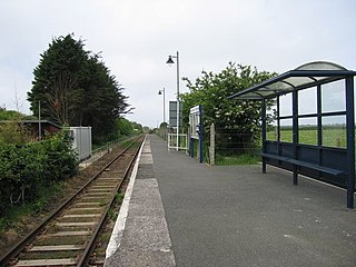
Goonhavern Halt (Cornish: Goonhavar) (50°20′30″N5°06′26″W / 50.3416°N 5.1072°W / 50.3416; -5.1072 (Goonhavern Halt)) was opened on 14 August 1905, on the right of trains travelling towards Newquay. It had a pagoda shelter and a siding until 1919 for the purpose of delivering pit props for nearby mines. The halt and adjacent road bridge survived until 1983 when most of the formation of the railway was obliterated and the cutting filled in.[7]
A branch from Newquay to Treamble had been opened by the Cornwall Minerals Railway on 1 June 1874.[3] When the Truro and Newquay line was constructed a passing loop was installed with two passenger platforms, immediately west of the junction for the Treamble line, which remained a goods line. The new line and the station opened on 2 January 1905 (50°20′55″N5°04′09″W / 50.3486°N 5.0692°W / 50.3486; -5.0692 (Shepherds railway station)). It was remote from any centre of population, and the name derived from former mine workings at the location.[2] There was a small goods yard opposite the junction and a camping coach was later kept at the station.[5]
The Treamble line closed in 1917 and the rails were lifted and sent to France to help with the war effort but due to an upturn in the mineral market, the line was reopened in 1926. It was again closed on 1 January 1952 although there had been no traffic over it since 8 August 1949. The track was not removed until 1956.
Mitchell and Newlyn Halt (Cornish: Pansmoren hag Eglosnywlin) (50°21′28″N5°02′45″W / 50.3577°N 5.0458°W / 50.3577; -5.0458 (Mitchell and Newlyn Halt)) serving the villages of Mitchell and St Newlyn East opened on 14 August 1905. It had a single wooden platform on the left of trains going to Newquay, but this was later replaced by a concrete platform.[8] The platform and waiting shelter may still survive amongst the undergrowth just across the road from the terminus of the Lappa Valley Railway, but are now inaccessible.[2]
Trevemper Siding served an industrial factory; it was on a short section of the Treffry Tramways route that was by-passed when the main line was improved. After closure of the line on 4 February 1963, the Siding and the route to Tolcarn was retained until final closure on 28 October 1963.
Tolcarn Junction was a triangular junction before the time of the Truro line; it was a legacy of the Cornwall Mineral Railways traffic from East Wheal Rose to Fowey. The spur avoiding Newquay was called Treloggan Curve, and the junction nearest Perranporth was Lane Junction; that nearest Par was Newquay Junction or Treloggan Junction; that nearest Newquay was Tolcarn Junction.[7]
Treloggan curve had been taken out of use in 1888, but it was reinstated in 1931 for the purpose of turning engines when the station turntable was abolished to enable enlargement of the siding facilities. The line from Tolcarn Junction to Newquay remained single until March 1946.[13]
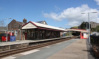
The Newquay Railway was opened in 1846 and a passenger service provided to Fowey from 20 June 1876. The station was rebuilt with three platforms to accommodate the opening of the Truro and Newquay line; the new facilities came into use on 7 June 1905.[2] It has since been reduced to a single track. It continues to serve Atlantic Coast Line trains from Par and a number of long-distance services on summer Saturdays.
Gradients
The line was steeply graded. Leaving Chacewater it climbed at 1 in 72 / 1 in 60 to Mount Hawke; it descended from St Agnes at 1 in 60 / 1 in 99, steepening to 2 miles (3km) at 1 in 51 / 1 in 47 after Mithian. Leaving Perranporth it climbed for 3 miles at 1 in 64 / 1 in 45 to a summit just short of Shepherds, from where it descended for 3 miles (5km) at 1 in 45 to a location beyond Mitchell and Newlyn. Still falling to beyond Trewerry, the last 3 miles (5km) were relatively gentle.[13]
Notes
↑ The LSWR had purchased the Bodmin and Wadebridge Railway in 1835 but that short local line was disconnected from the rest of the network.
Related Research Articles
Perranporth is a seaside resort town on the north coast of Cornwall, England, United Kingdom. It is 2.1 miles east of the St Agnes Heritage Coastline, and around 7 miles south-west of Newquay. Perranporth and its 2 miles (3 km) long beach face the Atlantic Ocean. It has a population of 3,066, and is the largest settlement in the civil parish of Perranzabuloe. It has an electoral ward in its own name whose population was 4,270 in the 2011 census.
The Bodmin and Wenford Railway is a 6 miles 12 chains (9.9 km) heritage railway at Bodmin in Cornwall, England. Its headquarters are at Bodmin General railway station and it connects with the national rail network at Bodmin Parkway.
The Lappa Valley Railway is a 15 in minimum gauge railway located near Newquay in Cornwall. The railway functions as a tourist attraction, running from Benny Halt to East Wheal Rose, where there is a leisure area with two miniature railways.
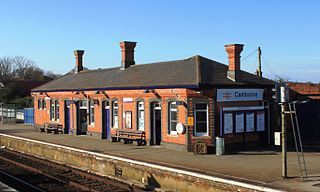
The Maritime Line is a railway line that runs in the valley of the River Fal from Truro, the county town, to Falmouth on the south coast of Cornwall, England.
Mount Hawke is a village in Cornwall, United Kingdom. It is situated approximately eight miles (13 km) west-northwest of Truro, five miles (8.0 km) north-northeast of Redruth, and two and a half miles (4.0 km) south of St Agnes.
Truro railway station serves the city of Truro, Cornwall, England. The station is 300 miles 63 chains from the zero point at London Paddington measured via Box and Plymouth Millbay. It is situated on the Cornish Main Line and is the junction for the Maritime Line to Falmouth Docks.
Redruth station serves the town of Redruth, Cornwall, United Kingdom, and is situated on the Cornish Main Line between Truro and Camborne. The station is 309 miles 68 chains from the zero point at London Paddington measured via Box and Plymouth Millbay.
Camborne railway station serves the town of Camborne, Cornwall, England. The station is 313 miles 40 chains from the zero point at London Paddington measured via Box and Plymouth Millbay.
Falmouth Town railway station is the most central of the stations in Falmouth, Cornwall, England. It is unstaffed; the station and the trains are operated by Great Western Railway. Despite only being opened in 1970, the station has been known by three different names: Falmouth, The Dell, and Falmouth Town.
Quintrell Downs railway station serves the village of Quintrell Downs in Cornwall, England. It is 300 miles 16 chains measured from the zero point at London Paddington, on the Atlantic Coast Line. The station is managed by Great Western Railway with local services in each direction all calling here.
Newquay railway station serves the town and seaside resort of Newquay in Cornwall, England. It is the terminus of the Atlantic Coast Line from Par, 302 miles 49 chains from the zero point at London Paddington measured via Box and Plymouth Millbay. The station is situated in the heart of Newquay, close to the town centre itself and the beaches. The station is managed by Great Western Railway which operates local branch line services to and from Par. In the summer, there are also services to and from London.
The West Cornwall Railway was a railway company in Cornwall, Great Britain, formed in 1846 to construct a railway between Penzance and Truro. It purchased the existing Hayle Railway, and improved its main line, and built new sections between Penzance and Hayle, and between Redruth and Truro, and opened throughout in 1852.
The North Cornwall Railway was a railway line running from Halwill in Devon to Padstow in Cornwall via Launceston, Camelford and Wadebridge, a distance of 49 miles 67 chains. Opened in the last decade of the nineteenth century, it was part of a drive by the London and South Western Railway (LSWR) to develop holiday traffic to Cornwall. The LSWR had opened a line connecting Exeter with Holsworthy in 1879, and by encouraging the North Cornwall Railway it planned to create railway access to previously inaccessible parts of the northern coastal area.
The Cornwall Minerals Railway owned and operated a network of 45 miles (72 km) of standard gauge railway lines in central Cornwall, England, United Kingdom. It started by taking over an obsolescent horse-operated tramway in 1862, and it improved and extended it, connecting Newquay and Par Harbours, and Fowey. Having expended considerable capital, it was hurt by a collapse in mineral extraction due to a slump in prices. Despite its title, it operated a passenger service between Newquay and Fowey.
There are seventeen disused railway stations on the Cornish Main Line between Plymouth in Devon and Penzance in Cornwall, England. The remains of nine of these can be seen from passing trains. While a number of these were closed following the so-called "Beeching Axe" in the 1960s, many of them had been closed much earlier, the traffic for which they had been built failing to materialise.
There are eight disused railway stations between Wadebridge and Bodmin North on the former Bodmin and Wadebridge Railway in Cornwall, in the United Kingdom, with ten other closed sidings on the branches to Ruthern Bridge and Wenfordbridge. The section from Boscarne Junction to Bodmin General is currently part of the Bodmin and Wenford Steam Railway; the line from Wadebridge to Wenfordbridge is now part of the Camel Trail, and the line to Ruthern Bridge can be followed for much of its length as it runs parallel to a public road.
The Langport and Castle Cary Railway is a railway line from Castle Cary railway station to Cogload Junction near Taunton, Somerset, England, which reduced the length of the journey from London to Penzance by 20+1⁄4 miles (32.6 km).
Mithian is a village in Cornwall, England, United Kingdom. It is about six miles (9.6 km) northeast of Redruth and a mile east of St Agnes.
Presented below is an alphabetical index of articles related to Cornwall:
↑ McRae, Andrew (1997). British Railway Camping Coach Holidays: The 1930s & British Railways (London Midland Region). Vol.Scenes from the Past: 30 (Part One). Foxline. p.31. ISBN1-870119-48-7.
↑ Fenton, Mike (1999). Camp Coach Holidays on the G.W.R. Wild Swan. pp.144–145. ISBN1-874103-53-4.
↑ McRae, Andrew (1998). British Railways Camping Coach Holidays: A Tour of Britain in the 1950s and 1960s. Vol.Scenes from the Past: 30 (Part Two). Foxline. p.95. ISBN1-870119-53-3.
1 2 Mitchell, Vic; Smith, Keith (2001). Branch Lines to Newquay. Midhurst: Middleton Press. ISBN1-901706-71-0.
This page is based on this Wikipedia article Text is available under the CC BY-SA 4.0 license; additional terms may apply. Images, videos and audio are available under their respective licenses.