Liberia, officially the Republic of Liberia, is a country on the West African coast. It is bordered by Sierra Leone to its northwest, Guinea to its north, Ivory Coast to its east, and the Atlantic Ocean to its south and southwest. It has a population of around 5 million and covers an area of 43,000 square miles (111,369 km2). The country's official language is English; however, over 20 indigenous languages are spoken, reflecting the country's ethnic and cultural diversity. The capital and largest city is Monrovia.
Liberia is a sub-Saharan nation in West Africa located at 6 °N, 9 °W. It borders the north Atlantic Ocean to the southwest and three other African nations on the other three sides, Sierra Leone to the northwest, Guinea to the northeast and Ivory Coast to the east.

Monrovia is the capital city of the West African country of Liberia. Founded in 1822, it is located on Cape Mesurado on the Atlantic coast and as of the 2008 census had 1,010,970 residents, home to 29% of Liberia’s total population. As the nation's primate city, Monrovia is the country's economic, financial and cultural center; its economy is primarily centered on its harbor and its role as the seat of Liberian government.

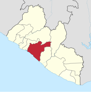
Montserrado County is a county in the northwestern portion of the West African nation of Liberia containing its national capital, Monrovia. One of 15 counties that comprise the first-level of administrative division in the nation, it has 17 sub political districts. As of the 2008 Census, it had a population of 1,118,241, making it the most populous county in Liberia. The area of the county measures 1,912.7 square kilometres (738.5 sq mi), the smallest in the country. Bensonville serves as the capital.

Grand Cape Mount is a county in the northwestern portion of the West African nation of Liberia. One of 15 counties that constitute the first-level of administrative division in the nation, it has five districts. Robertsport serves as the capital with the area of the county measuring 5,162 square kilometres (1,993 sq mi). As of the 2008 Census, it had a population of 129,817, making it the eighth most populous county in Liberia. The county is bordered by Gbarpolu County to the northeast and Bomi County to the southeast. The northern part of Grand Cape Mount borders the nation of Sierra Leone, while to the west lies the Atlantic Ocean.

Buchanan, also previously known as Grand Bassa on some maps, is the third largest city in Liberia, lying on Waterhouse Bay, part of the Atlantic Ocean. As of the 2008 census, Buchanan had a population of 34,270. Of this, 16,984 were male and 17,286 female.
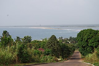
Robertsport is a town in western Liberia, about 10 miles from the Sierra Leone border. It is named after Joseph Jenkins Roberts, the first president of Liberia.

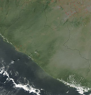
Guinée forestière is a forested mountainous region in southeastern Guinea, extending into northeastern Sierra Leone. It is one of four natural regions into which Guinea is divided and covers 23% of the country. It includes all of the Nzérékoré administrative region, and shares a border with Sierra Leone and Liberia. Its rocky topology contains several mountain ranges and has an average elevation of 460m. Forested Guinea contains important areas of biological diversity such as the UNESCO World Heritage site Mount Nimba Strict Nature Reserve and biosphere reserve Ziama Massif. The Guéckédou prefectures also recorded the initial case of the 2014 Ebola outbreak in Meliandou, a rural village. The virus subsequently spread to urban areas and neighbouring countries Sierra Leone and Liberia.
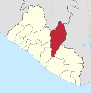
Nimba County is a county in northeastern Liberia that shares borders with the Republic of Côte d'Ivoire in the East and the Republic of Guinea in the Northwest. Its capital city is Sanniquellie and its most populous city is Ganta. With the county's area measuring 11,551 square kilometres (4,460 sq mi), Nimba is the largest of Liberia's 15 counties. The county has six statutory districts. As of the 2008 Census, it had a population of 462,026, making it the second most-populous county in Liberia.

Gbarpolu is a county in the northern portion of Liberia. One of 15 counties that comprise the first-level of administrative division in the nation, it has six districts. Bopulu serves as the capital with the area of the county measuring 9,689 square kilometres (3,741 sq mi). As of the 2008 Census, it had a population of 83,758, making it the eleventh-most populous county in Liberia.

Schefferville is a town in the Canadian province of Quebec. Schefferville is in the heart of the Naskapi and Innu territory in northern Quebec, less than 2 km from the border with Labrador on the north shore of Knob Lake. It is located within the Caniapiscau Regional County Municipality and has an area of 24.76 square kilometres (9.56 sq mi). Schefferville completely surrounds the autonomous Innu community of Matimekosh, and it abuts the small community of Lac-John Reserve. Both of the latter communities are First Nations Innu reserves. Schefferville is also close to the Naskapi reserved land of Kawawachikamach.

Bomi is a county in the northwestern portion of the West African nation of Liberia. The county was established in 1984. The county's area is 746 square miles (1,900 km2).

Bong is a county in the north-central portion of the West African nation of Liberia. One of 15 counties that comprise the first-level of administrative division in the nation, it has twelve districts. Gbarnga serves as the capital. The area of the county measures 8,772 square kilometres (3,387 sq mi). As of the 2008 Census, it had a population of 328,919, making it the third-most populous county in Liberia. The county was organized in 1964 and is important for its mining industry.
Grand Bassa is a county in the west-central portion of the West African nation of Liberia. One of 15 counties that comprise the first-level of administrative division in the nation, it has eight districts. Buchanan serves as the capital with the area of the county measuring 7,936 square kilometres (3,064 sq mi). As of the 2008 Census, it had a population of 224,839, making it the fifth most populous county in Liberia.
The Freeport of Monrovia is the main commercial port facility in the West African nation of Liberia. It was artificially created on Bushrod Island near Monrovia in 1948. The facility contains four piers and one main wharf with four berths. The port also has tanker facilities and a fishery pier. The National Port Authority operates it.
The history of rail transport in Liberia began shortly after World War II, when the Freeport of Monrovia was completed, with limited rail access. It had been developed by American military forces.

Amara M. Konneh a Liberian national with more than 25 years of experience in humanitarian, private sector, government, and international development work, is a Senior Advisor on Partnerships and Regional Integration covering Africa for the World Bank. In this role, he advises the World Bank on regional economic integration to create economic hubs for value chains and helps build strategic partnerships with Africa's regional economic commissions. Prior to that, he served as Lead Advisor for the Bank's engagements in countries affected by fragility, conflict, violence, and forced displacement with emphasis on Ethiopia, Eritrea, Kenya, and Nigeria.

The mining industry of Liberia has witnessed a revival after the civil war which ended in 2003. Gold, diamonds, and iron ore form the core minerals of the mining sector with a new Mineral Development Policy and Mining Code being put in place to attract foreign investments. In 2013, the mineral sector accounted for 11% of GDP in the country and the World Bank projected a further increase in the sector by 2017.

Ahmadiyya is an Islamic religious movement in Liberia. Founded in the year 1956, during the era of the Second Caliphate, the movement today represents an estimated 10% of the country's Muslim population. Approximately, this corresponds to 85,000 Ahmadi Muslims in Liberia. Current National President is Maulvi Naveed Ahmad Aadil.
The Maher Massacre took place during the Second Liberian Civil War in Maher, Bomi County, on July 18, 2002.