Tuckingmill, Camborne, Cornwall

Last updated

Tuckingmill
Pendarves Street, Tuckingmill (geograph 1812494).jpg
Pendarves Street, Tuckingmill
Cornwall UK mainland location map.svg
Red pog.svg
Tuckingmill
Location within Cornwall
OS grid reference SW658405
Unitary authority
Ceremonial county
Region
Country England
Sovereign state United Kingdom
Post town Camborne
Postcode district TR14
Dialling code 01209
Police Devon and Cornwall
Fire Cornwall
Ambulance South Western
UK Parliament
List of places
UK
England
Cornwall
50°13′19″N5°16′59″W / 50.222°N 5.283°W / 50.222; -5.283

Tuckingmill (Cornish : Talgarrek, meaning hill-brow of a rock) is a village in Cornwall, England, United Kingdom, which is in the civil parish of Camborne. Tucking Mill (Cornish : Melyn Droghya, from the verb troghya) was the Cornish term for a fulling mill which was where homespun cloth was dipped, cleansed and dressed. There is a mention of a fulling mill in this region as early as 1250. The ecclesiastical parish of Tuckingmill was constituted in 1845, being carved out of a western section of the parish of Illogan and an eastern section of Camborne parish. It covers 1,300 acres (5.3 km2).

Contents

Geography

Tuckingmill is a post-industrial village on the A3047, between the former mining towns of Camborne and Redruth. Camborne-Redruth is the largest urban area in Cornwall, and is on the northern side of the Carn Brea/Carnmenellis granite upland, which slopes northwards to the coast.

Cutting north-south is the deeply cut valley of the Red River, which has been exploited for minerals and other industrial processes for centuries. Settlements between Camborne and Redruth were on the original country road which was turnpiked in 1839, later becoming the A30 and now the A3047. [1] [2]

History

Evidence of prehistoric settlement is from the name of nearby Roskear, which refers to a fortified site, probably an Iron Age round (farmstead), and there are records of mills in the Red River valley in the 13th-century. [1]

Mining was probably centuries old, with tin-streaming in the valley, when examples of deep-mined copper were recorded from the late 17th-century. Cook's Kitchen is recorded by 1690, as is Dolcoath, and on a 1748 map, mines are shown at Dolcoath and South Roskear. A copper foundry at Entral was started by Sampson Swaine and other gentlemen of Camborne in 1754, and Long Close, Wheal Crofty and Wheal Susan were mines operating in what is now the built-up area of Tuckingmill. The parish also contained what is said to be the greatest of all Cornish mines, Dolcoath and also the South Crofty Mine, which was at one time the deepest in the world as well as being the last tin mine in Europe, only closing in 1998. [1]

William Bickford took out a patent in 1831 for the safety fuse; a device for igniting gunpowder that saved many lives. With his son-in-law George Smith, he established a factory and in its first year produced 45 miles (72 km) of fuse. Bickford died just before the factory opened. [3]

View from Dolcoath Mine towards Redruth, ca 1890 Tin-mining-cornwall-c1890.jpg
View from Dolcoath Mine towards Redruth, ca 1890

Religion

The parish church of All Saints was built in 1843–44 in the Norman Revival style, with the north aisle having a heavy granite arcade. The architect was John Hayward of Exeter. The Norman font came from the chapel at Menadarva. [4] The church was renovated in 1878–79 by Piers St Aubyn with the raising and tiling of the chancel, removing the tower gallery, replacing the seats and repairing the walls and windows. A reredos with an ″Irish serpentine″ border, inlaid with marble and also designed by Mr Piers St Aubyn was completed in November 1882. [5] The cross is made of alabaster. [6] A new organ, costing £120, was purchased from Hele and Sons of Plymouth. The church was re-opened on Thursday, 20 February 1879. [7]

Economy and development

The area consists of terraced miners' cottages and rather barren industrialisation. With the demise of this economic activity, many thousands of jobs were lost and Tuckingmill became a bleak post-industrialisation urban area. However, around the turn of the millennium, regeneration has picked up and improvements are expected over the next few years. Kerrier Council's bid for £23 million from the BIG Lottery Fund was successful - and announced in November 2007. The grant will be used to re-build the Pool area between Redruth and Camborne (Pool sits at the top of East Hill, immediately next to Tuckingmill).

A Cornish property development firm called Porthia acquired a huge site at the centre of Tuckingmill. The site includes the old Fuseworks building and brownfield land previously mined by South Crofty. It was their intention to transform this site into "New Tuckingmill" – a development of over 400 new homes as well as commercial space and community facilities. Porthia's environmental proposal failed to satisfy Kerrier Council, so it stalled.[ citation needed ]

However, construction of 67 new home affordable homes began at a Tuckingmill site in 2023, following an investment agreement between Cornwall Pension Fund, PGIM Real Estate, and Brunel Pension Partnership. [8] [9] [10]

Tuckingmill Valley Park

This is a green flag accredited, award-winning restored public space. It was regenerated by Cornwall Council having previously been a derelict space. [11] [12]

The Red river flow through the park, and facilities include a skatepark. [13]

It is designated as a strategic park within Kerrier, and is managed by Cornwall Council. [14]

Notable residents

William Bickford, inventor of the safety fuse, lived and worked in Tuckingmill.

Ben Salfield (b.1971), lutenist, author, composer and promoter, lives in Tuckingmill.

Related Research Articles

<span class="mw-page-title-main">Redruth</span> Town and civil parish in Cornwall, England

Redruth is a town and civil parish in Cornwall, England, United Kingdom. The population of Redruth was 14,018 at the 2011 census. In the same year the population of the Camborne-Redruth urban area, which also includes Carn Brea, Illogan and several satellite villages, stood at 55,400 making it the largest conurbation in Cornwall. Redruth lies approximately at the junction of the A393 and A3047 roads, on the route of the old London to Land's End trunk road, and is approximately 9 miles (14 km) west of Truro, 12 miles (19 km) east of St Ives, 18 miles (29 km) north east of Penzance and 11 miles (18 km) north west of Falmouth. Camborne and Redruth together form the largest urban area in Cornwall and before local government reorganisation were an urban district.

<span class="mw-page-title-main">Camborne</span> Town in Cornwall, England

Camborne is a town in Cornwall, England, United Kingdom. The population at the 2011 Census was 20,845. The northern edge of the parish includes a section of the South West Coast Path, Hell's Mouth and Deadman's Cove.

<span class="mw-page-title-main">Camborne railway station</span> Railway station in Cornwall, England

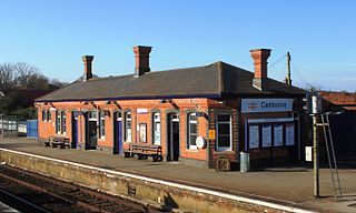
Camborne railway station serves the town of Camborne, Cornwall, England. The station is 313 miles 40 chains from the zero point at London Paddington measured via Box and Plymouth Millbay.

<span class="mw-page-title-main">King Edward Mine</span> Former mine in Camborne, Cornwall

The King Edward Mine at Camborne, Cornwall, in the United Kingdom is a mine wholly owned by Cornwall Council.

<span class="mw-page-title-main">Mining in Cornwall and Devon</span> Mining in the English counties of Cornwall and Devon

Mining in Cornwall and Devon, in the southwest of Britain, is thought to have begun in the early-middle Bronze Age with the exploitation of cassiterite. Tin, and later copper, were the most commonly extracted metals. Some tin mining continued long after the mining of other metals had become unprofitable, but ended in the late 20th century. In 2021, it was announced that a new mine was extracting battery-grade lithium carbonate, more than 20 years after the closure of the last South Crofty tin mine in Cornwall in 1998.

<span class="mw-page-title-main">Gwennap</span> Village and civil parish in Cornwall, England

Gwennap is a village and civil parish in Cornwall, England, United Kingdom. It is about five miles (8 km) southeast of Redruth. Hamlets of Burncoose, Comford, Coombe, Crofthandy, Cusgarne, Fernsplatt, Frogpool, Hick's Mill, Tresamble and United Downs lie in the parish, as does Little Beside country house.

<span class="mw-page-title-main">Crowan</span> Village and parish in Cornwall, England

Crowan is a village and civil parish in Cornwall, England, United Kingdom. It is about three-and-a-half miles (6 km) south of Camborne. A former mining parish, all of the mines had shut by 1880.

<span class="mw-page-title-main">William Bickford (1774–1834)</span> English inventor

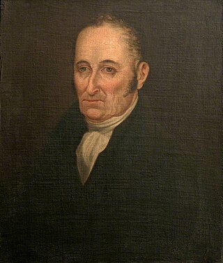
William Bickford (1774–1834) was an English inventor, who, formerly a currier, invented the safety fuse for use in mining.

<span class="mw-page-title-main">Dolcoath mine</span> Former copper and tin mine in Cornwall, England

Dolcoath mine was a copper and tin mine in Camborne, Cornwall, England, United Kingdom. Its name derives from the Cornish for 'Old Ground', and it was also affectionately known as The Queen of Cornish Mines. The site is north-west of Carn Brea. Dolcoath Road runs between the A3047 road and Chapel Hill. The site is south of this road.

<span class="mw-page-title-main">Hayle Railway</span>

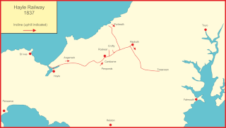
The Hayle Railway was an early railway in West Cornwall, constructed to convey copper and tin ore from the Redruth and Camborne areas to sea ports at Hayle and Portreath. It was opened in 1837, and carried passengers on its main line from 1843.

<span class="mw-page-title-main">Pool, Cornwall</span> Village in west Cornwall, England

Pool is a village in Carn Brea civil parish in west Cornwall, England. It is bypassed by the A30, on the A3047 between Camborne and Redruth, between Tuckingmill and Illogan Highway.

<span class="mw-page-title-main">South Crofty</span> Tin and copper mine in Cornwall, England

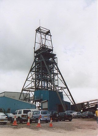
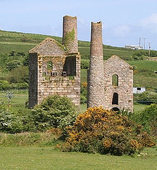
South Crofty is a metalliferous tin and copper mine located in the village of Pool, Cornwall, England. An ancient mine, it has seen production for over 400 years, and extends almost two and a half miles across and 3,000 feet (910 m) down and has mined over 40 lodes. Evidence of mining activity in South Crofty has been dated back to 1592, with full-scale mining beginning in the mid-17th century. The mine went into serious decline after 1985 and eventually closed in 1998. After several changes of ownership, South Crofty is owned by Cornish Metals Inc, which is working to re-open the mine, as of November 2022, having receive a permit for dewatering the mine.

<span class="mw-page-title-main">Red River (Koner)</span> River in north-west Cornwall, England

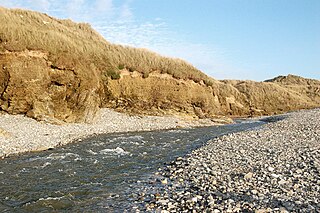
The Red River is a small river in north-west Cornwall, England, United Kingdom which issues into St Ives Bay at Godrevy on Cornwall's Atlantic coast. The Red River is about 8 miles (13 km) long and was given its name from the mineral deposits associated with tin mining, particularly oxides of Iron, which formerly coloured its water red. The river's gradient is relatively steep; the stream falls 170 metres (560 ft) from source to sea.

<span class="mw-page-title-main">East Pool mine</span> Former metalliferous mine in Cornwall, England

East Pool mine, was a metalliferous mine in the Camborne and Redruth mining area, just east of the village of Pool in Cornwall, England. Worked from the early 18th century until 1945, first for copper and later tin, it was very profitable for much of its life. Today the site has two preserved beam engines and is part of the Cornwall and West Devon Mining Landscape World Heritage Site. It is owned by the National Trust.

<span class="mw-page-title-main">Basset Mines</span> Mining company in Cornwall, England

Basset Mines was a mining company formed in Cornwall, England, by the amalgamation of six copper and tin mining setts. It operated from 1896 until 1918, when it was closed due to a fall in the price of tin.

Presented below is an alphabetical index of articles related to Cornwall:

<span class="mw-page-title-main">All Saints' Church, Tuckingmill</span> Church in Cornwall, England

All Saints’ Church, Tuckingmill is a Grade II listed parish church in the Church of England in Pendarves Street, Tuckingmill, Camborne, Cornwall.

<span class="mw-page-title-main">Camborne Roskear (electoral division)</span> Former electoral division of Cornwall in the UK

Camborne Roskear was an electoral division of Cornwall in the United Kingdom which returned one member to sit on Cornwall Council between 2013 and 2021. It was abolished at the 2021 local elections, being succeeded by Camborne Roskear and Tuckingmill.

<span class="mw-page-title-main">Old Council Offices, Camborne</span> Municipal building in Camborne, Cornwall, England

The Old Council Offices are in Trevenson Street, Camborne, Cornwall, England. The building, which was used as the offices of Camborne-Redruth Urban District Council and is currently vacant, is a grade II listed building.

References

  1. 1 2 3 Cahill, Nick J (2002). Cornwall Industrial Settlements Initiative. Tuckingmill and Roskear (Camborne-Redruth Area). Truro: Cornwall County Council.
  2. OS Explorer Map 104. Redruth & St Agnes (Map) (B2 ed.). Southampton: Ordnance Survey. 2013. ISBN   978 0 319 24034 2.
  3. "William Bickford, inventor of the safety fuse". Cornwall Calling. Retrieved 18 December 2016.
  4. Pevsner, N (1970) Cornwall; 2nd ed., revised by E Radcliffe. Harmondsworth: Penguin; p. 236
  5. "A Very handsome reredos". The Cornishman. No. 240. 15 February 1883. p. 7.
  6. "Penzance". The Cornishman. No. 229. 30 November 1882. p. 4.
  7. "Roskear Church". The Cornishman. No. 33. 27 February 1879. p. 5.
  8. https://www.room151.co.uk/151-news/cornwall-pension-fund-and-pgim-real-estate-complete-joint-housing-acquisition/
  9. https://realassets.ipe.com/news/cornwall-pension-fund-and-pgim-to-develop-local-affordable-housing/10069797.article
  10. https://www.sustain-re.com/pgim-to-build-affordable-housing-in-cornwall/
  11. www.srstudio.co.uk, SRStudio Design -. "Tuckingmill Valley Park Camborne | Discover Cornwall". cornwallmaps.org. Retrieved 8 October 2017.
  12. "Record number of parks and green spaces awarded Green Flag Awards for 2015" . Retrieved 8 October 2017.
  13. Council, Cornwall. "Tuckingmill Valley Park - Cornwall Council". www.cornwall.gov.uk. Retrieved 8 October 2017.
  14. "Microsoft Word - GFA_Management_Document_FINAL12-03-09.doc" (PDF). Retrieved 24 October 2019.

Commons-logo.svg Media related to Tuckingmill at Wikimedia Commons