
Bhavānī is an epithet associated with Adi Shakti (Durga). Bhavani translates to "giver of life," meaning the power of nature or the source of creative energy. She is considered to be a nurturing mother figure who provides for her devotees and also plays the role of dispensing justice by killing evil Asuras.

Osmanabad District, officially known as Dharashiv District, is an administrative district in the Marathwada region in the Indian state of Maharashtra. The district headquarter is located at Osmanabad. The District of Osmanabad derives its name from the last ruler of Hyderabad, the 7th Nizam, Mir Osman Ali Khan, of which the region was a part till 1947. This region was earlier part of The Hyderabad State until Independence.This primarily rural district occupies an area of 7,569 km2 (2,922 sq mi) of which 241.4 km2 (93.2 sq mi) is urban and has a population of 1,657,576 of which 16.96% were urban.
Pandharpur is a popular pilgrimage town, on the banks of Chandrabhagā River, near Solapur city in Solapur District, Maharashtra, India. Its administrative area is one of eleven tehsils in the District, and it is an electoral constituency of the state legislative assembly. The Vithoba temple attracts about a million Hindu pilgrims during the major yātrā (pilgrimage) in Ashadha (June–July).

Osmanabad, officially known as Dharashiv, is a city and a municipal council in Osmanabad district in the Indian state of Maharashtra. The city is the administrative headquarter of Osmanabad district. It is the seventh largest city in Marathwada, and the 39th largest city in Maharashtra by population.

Sangli district is a district of Maharashtra state in India. Sangli city is the district headquarters. It is bordered by Satara district, Solapur district to the North, Karnataka state to the South-East, by Kolhapur district to South-West and by narrow portion on the East side to Ratnagiri district. It is present on the southern tip of Maharashtra.

Barshi is a city located in Barshi Sub district of Solapur District of Maharashtra State of Republic of India.
Ambad is a town with a municipal council in Jalna district in the state of Maharashtra, India. Ambad is notable for its temple dedicated to the Hindu goddess Matsyodari. In October of each year, devotees of the goddess gather in Ambad for the Hindu festival of Dashahara. A local tradition claims that the name "Ambad" was given to this city by a Hindu Raja named Ambarisha. According to this tradition, Raja Ambarisha would worship the goddess on a rock hill which resembled a fish. Because of this fish-shaped rock hill, the goddess was named Matsyodari. The temple was constructed by Ahilya Devi Holkar, who also has developed Ambad by constructing Pushkarini and Kavandi. Ambad is the second most populous town in district of Jalna. Ambad also has a Government Polytechnic College which is one of the only two Government Polytechnic Colleges located in Jalna district along with Government Polytechnic, Jalna. Ambad municipal council is convened at Court Road.

Chiplun ( [t͡ʃipɭuːɳ]) is a city in Ratnagiri district in the state of Maharashtra, India. It is one of the financial and commercial hubs of Ratnagiri district, and the headquarters of Chiplun taluka. It is about 250 km south of Mumbai and 90 km North of Ratnagiri in the Konkan region of Maharashtra, on the Mumbai–Goa highway (NH-66). It has a long history and a strong cultural background. Recent decades have seen much industrial development in it and its and surrounding areas.
Paranda is a town with a municipal council in the Osmanabad district of the Indian state of Maharashtra. It is the headquarters town for the Paranda Tehsil.

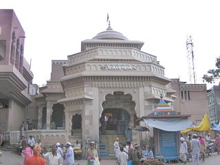
Shree Tulaja Bhavani Temple is a Hindu temple dedicated to goddess Bhavani. It is located in Tuljapur in Dharashiv district of Maharashtra, India, and is considered as one of the 51 Shakti Pithas. It is situated 45 km from Solapur. The temple was built in 12th century CE by Maratha Mahamandaleshwara Māradadeva of the Kadamb dynasty.
Hadapsar is a developed town in eastern Pune City, Maharashtra, India. After 1990, Hadapsar developed into a major industrial area and is now one of the most densely populated and developed areas of Pune District. It is well connected to all parts of city. Distances to popular city centers is: Pune Railway Station 8 km, Lohegaon Airport 8 km, Koregaon Park 5 km, Swargate Bus Stand 7 km and Shivaji Nagar Railway Station 12 km.
Vairag is a town in Barshi Taluka of Solapur district in Maharashtra, India. The village is located centrally between Solapur and Barshi.

Maharashtra attracts tourists from other Indian states and foreign countries. It was the second most visited Indian state by foreigners and fifth most visited state by domestic tourists in the country in 2021. Aurangabad is the tourism capital of Maharashtra.
Alur is a panchayat village in the state of Maharashtra, India. It is administratively under the Umarga Tahsil of Osmanabad District in Maharashtra. There is only the single village of Alur in the Alur gram panchayat. The village is 31 km by road southeast of Naldurg and 52 km by road southwest of Umarga, but only 13 km by road northeast of Wagdari, in Solapur District.

Tourism in Marathwada refers to tourism in the Marathwada region of Maharashtra state in India. Aurangabad is a regional headquarters in Marathwada, and the tourism capital of Maharashtra state. Out of the four UNESCO World Heritage Sites in Maharashtra, two are in the Marathwada region. There are also 110 monuments in Marathwada which are protected by Government of Maharashtra and recognized by Archaeological Survey of India.
Dahitane is a village in the Barshi Taluka of Solapur district in Maharashtra, India. It is a village panchayat located between the town of Vairag and the tehsil of Mohol.
Peddamunigal, also known as Munigal, is a Hindu temple situated on the banks of the Krishna River back of Nagarjuna Sagar Dam. and surrounded with Nallamala Forest in Nalgonda district of the Indian state of Telangana. The Temple is said to be an abode of Bhavani.
Three and a half Shakti Peethas are reported in Maharashtra.
Yenegur is a major village located in Omerga tehsil of Osmanabad district, which is part of the Marathwada region of the state of Maharashtra in India.

Praveen Gedam is an Indian civil servant who has been serving as Divisional Commissioner of Nashik since 31 May 2024. An Indian Administrative Service officer of the 2002 Maharashtra cadre, he has held a number of governmental roles, including as Additional Deputy CEO of the National Health Authority; Agriculture Commissioner, Maharashtra; Transport Commissioner, Maharashtra; Municipal Commissioner in Nashik and Jalgaon; and District Collector in Solapur and Osmanabad.


