Sikkim is a state in northeastern India. It borders the Tibet Autonomous Region of China in the north and northeast, Bhutan in the east, Koshi Province of Nepal in the west, and West Bengal in the south. Sikkim is also close to the Siliguri Corridor, which borders Bangladesh. Sikkim is the least populous and second-smallest among the Indian states. Situated in the Eastern Himalaya, Sikkim is notable for its biodiversity, including alpine and subtropical climates, as well as being a host to Kangchenjunga, the highest peak in India and third-highest on Earth. Sikkim's capital and largest city is Gangtok. Almost 35% of the state is covered by Khangchendzonga National Park – a UNESCO World Heritage Site.

Gangtok is the capital and the most populous city of the Indian state of Sikkim. The seat of eponymous district, Gangtok is in the eastern Himalayan range, at an elevation of 1,650 m (5,410 ft). The city's population of 100,000 consists of the three Sikkimese ethnicities: the Bhutias, Lepchas, Nepalis as well as plainsmen from other states of India. Within the higher peaks of the Himalayas and with a year-round mild temperate climate, Gangtok is at the centre of Sikkim's tourism industry.

The history of Sikkim begins with the indigenous Lepcha's contact with early Tibetan settlers. Historically, Sikkim was a sovereign Monarchical State in the eastern Himalayas. Later a protectorate of India followed by a merger with India and official recognition as a state of India. Lepchas were the main inhabitants as well as the Rulers of the land up to 1641. Lepchas are generally considered to be the first people, Indigenous to Sikkim also includes Darjeeling.

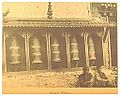
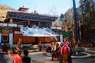
The Enchey Monastery was established in 1909 above Gangtok, the capital city of Sikkim in the Northeastern Indian state. It belongs to the Nyingma order of Vajrayana Buddhism. The monastery built around the then small hamlet of Gangtok became a religious centre. The location was blessed by Lama Drupthob Karpo, a renowned exponent of tantric (adept) art in Buddhism with flying powers; initially a small Gompa was established by him after he flew from Maenam Hill in South Sikkim to this site. The literal meaning of Enchey Monastery is the "Solitary Monastery". Its sacredness is attributed to the belief that Khangchendzonga and Yabdean – the protecting deities – reside in this monastery. As, according to a legend, Guru Padmasambhava had subdued the spirits of the Khangchendzonga, Yabdean and Mahākāla here. In view of this legend, the religious significance of Enchey Monastery is deeply ingrained in every household in Gangtok. It is also believed that these powerful deities always fulfil the wishes of the devotees.

Yuksom is a historical town, just 40 km north of Gyalshing city in the Gyalshing district in the Northeast Indian state of Sikkim. It was the first capital of Kingdom of Sikkim established in 1642 AD by Phuntsog Namgyal who was the first Chogyal of Sikkim. The coronation site of the first monarch of Sikkim is known as the "Throne of Norbugang". Yuksom is where there is the Norbugang Chorten near the Norbugang throne, the place Namgyal was crowned and several monasteries and a lake. The dynastic rule of the Chogyal lasted for 333 years.

Rabdentse was the second capital of the former Kingdom of Sikkim from 1670 to 1814. The capital city was destroyed by the invading Gurkha army and only the ruins of the palace and the chortens are seen here now. However, the ruins of this city are seen close to Pelling and in West Sikkim district in the Northeastern Indian state of present-day Sikkim; Pemayangtse Monastery is one of the oldest monasteries in Sikkim which is close to the ruins. From the vantage point of this former capital, superb views of the Khanchendzonga ranges can be witnessed. This monument has been declared as of national importance by the Archaeological Survey of India. It was first established in 1670 by the 2nd Chogyal Tensung Namgyal son of the 1st Chogyal Phuntsog Namgyal by shifting from the first capital of Yuksom that was consecrated in 1642.

Chungthang is a town in Mangan district in the Indian state of Sikkim. It is located just 28 km from Mangan town, the district headquarters. It is situated at the confluence of the Lachen and Lachung rivers, which combine to form the Teesta River. Located at a distance of 95 kilometres (59 mi) from the state capital Gangtok, the Indian Army has a major forward base with a medical centre in Chungthang.

Gurudongmar Lake is one of the highest lakes in the world and in India, at an elevation of 5,430 m (17,800 ft) according to the Government of Sikkim. It is located in the Great Himalayas in the Mangan District in Indian state of Sikkim, and considered sacred by Buddhists and Sikhs. The lake is named after Guru Padmasambhava—also known as Guru Rinpoche—founder of Tibetan Buddhism, who visited in the 8th century.
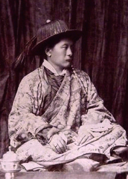
Thutob Namgyal was the ruling chogyal (monarch) of Sikkim between 1874 and 1914. Thutob ascended to the throne succeeding his half-brother Sidkeong Namgyal who died issueless. Differences between the Nepalese settlers and the indigenous population during his reign led to the direct intervention of the British, who were the de facto rulers of the Himalayan nation. The British ruled in favour of the Nepalese much to the discontent of the chogyal, who then retreated to the Chumbi Valley and allied himself with the Tibetans.

Namgyal Institute of Tibetology (NIT) is a Tibet museum in Gangtok, Sikkim, India, named after the 11th Chogyal of Sikkim, Sir Tashi Namgyal. The institute employs researchers and one of its new research programs is a project which seeks to document the social history of Sikkim's approximated 60 monasteries and record this on a computer. Another project seeks to digitize and document old and rare photographs of Sikkim for knowledge distribution. Khempo Dhazar served as head of the Sheda, a Nyingma college attached to the Institute, for six years.
Tsugphud Namgyal (1785–1863) was king of Sikkim from 1793 to 1863. He gained independence from Nepal in 1815 and ruled under a British protectorate from 1861.

The Kingdom of Sikkim, officially Dremoshong until the 1800s, was a hereditary monarchy in the Eastern Himalayas which existed from 1642 to 16 May 1975, when it was annexed by India. It was ruled by Chogyals of the Namgyal dynasty.

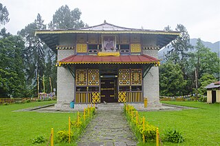
The Pemayangtse Monastery is a Buddhist monastery in Pemayangtse, near Gyalshing city in Gyalshing district in the northeastern Indian state of Sikkim, located 6 km from Gyalshing city, the district headquarters, 110 km west of Gangtok. Planned, designed and founded by Lama Lhatsun Chempo in 1647, it is one of the oldest and premier monasteries of Sikkim, also the most famous in Sikkim. Originally started as a small Lhakhang, it was subsequently enlarged during the reign of the third Chogyal Chakdor Namgyal and Khenchen Rolpai Dorjee in the year 1705 and consecrated by the third Lhatsun Chenpo Dzogchen Jigme Pawo in the year 1710 C.E. The monastery follows the Nyingma Order of Tibetan Buddhism and controls all other monasteries of that Order in Sikkim. The monks of this monastery are normally chosen from the Bhutias of Sikkim.
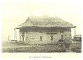
Dubdi Monastery, occasionally called Yuksom Monastery, is a Buddhist monastery of the Nyingma sect of Tibetan Buddhism near Yuksom, in the Geyzing subdivision of West Sikkim district, in eastern India.

Kabi Lungchok is a historic site of significance, which is located 17 kilometres (11 mi) north of Gangtok on the Northern Highway in northeastern Indian state of Sikkim. The historicity of the site is attributed to the fact that the Lepchas, the ethnic tribals of Sikkim and Bhutias, the immigrants from southern Bhot who settled down in Sikkim from the 14th century onwards, ceremonially signed a "Treaty of Blood Brotherhood" with religious fervour. Stone pillars mark the location where the treaty was signed. The Treaty was signed at Kabi Lungchok by the Bhot King, Khye Bumsa representing the Bhutias and the Lepcha Chief Thekong Tek. The literal meaning of 'Kabi Lungchok', pronounced ‘Kayu sha bhi Lungchok’, is "stone erected by our blood." Life-size statues of the Lepcha and Bhutia 'blood-brothers' who signed the treaty has been erected here.
Lachung Monastery is a Nyingma Buddhist gompa in the Lachung Valley in Mangan district in Northeastern Indian state of Sikkim. It is approx. 50 km from Mangan town, the district headquarters. It was established in 1880.

Mangan is a town and the headquarter of the district of Mangan District in the Indian state of Sikkim. The town lying near River Teesta is connected to the capital Gangtok by a metalled road. Mangan District is the largest district of Sikkim in terms of area. The town lies in the geographic south of the district. After the opening up of the district, Mangan has witnessed a spurt in its economy, mostly due to organic farming. The town opens up the Tibetan Plateau. Mangan also serves the towns of Lachung, Chungthang and Lachen in the far north. Owing to its elevation, the town enjoys a temperate climate.

The Sikkim expedition was an 1888 British military expedition to expel Tibetan forces from Sikkim. The roots of the conflict lay in British–Tibetan competition for suzerainty over Sikkim.
The Treaty of Tumlong was a March 1861 treaty between the British Empire and the Kingdom of Sikkim in present-day north-east India. Signed by Sir Ashley Eden on behalf of the British and by the Sikkimese Chogyal, Sidkeong Namgyal when his father Tsugphud Namgyal refused to return from Tibet, the treaty secured protection for travellers to Sikkim and guaranteed free trade, thereby making the state a de facto British protectorate.