
Burkittsville is a historic village in Frederick County, Maryland, United States. The village lies in the southern Middletown Valley along the eastern base of South Mountain.

Boonsboro is a town in Washington County, Maryland, United States, located at the foot of South Mountain. It nearly borders Frederick County and is proximate to the Antietam National Battlefield. The population was 3,336 at the 2010 census.

Sharpsburg is a town in Washington County, Maryland. The town is approximately 13 miles (21 km) south of Hagerstown. Its population was 705 at the 2010 census.

The town of Washington, Virginia, is a historic village located in the eastern foothills of the Blue Ridge Mountains near Shenandoah National Park. The entire town is listed on the National Register of Historic Places as a historic district, Washington Historic District. It is the county seat of Rappahannock County, Virginia.
The Battle of South Mountain—known in several early Southern accounts as the Battle of Boonsboro Gap—was fought on September 14, 1862, as part of the Maryland campaign of the American Civil War. Three pitched battles were fought for possession of three South Mountain passes: Crampton's, Turner's, and Fox's Gaps. Maj. Gen. George B. McClellan, commanding the Union Army of the Potomac, needed to pass through these gaps in his pursuit of Confederate General Robert E. Lee's precariously divided Army of Northern Virginia. Although the delay bought at South Mountain would allow him to reunite his army and forestall defeat in detail, Lee considered termination of the Maryland Campaign at nightfall.

Jesse Lee Reno was a career United States Army officer who served in the Mexican–American War, in the Utah War, on the western frontier and as a Union General during the American Civil War from West Virginia. Known as a "soldier's soldier" who fought alongside his men, he was killed while commanding a corps at Fox's Gap during the Battle of South Mountain. Reno, Nevada; Reno County, Kansas; Reno, Ohio; El Reno, Oklahoma; Reno, Pennsylvania; Fort Reno (Oklahoma); and Fort Reno Park in Washington, D.C. were named after him.

Turner's Gap is a wind gap in the South Mountain Range of the Blue Ridge Mountains, located in Frederick County and Washington County, Maryland. The gap is traversed by U.S. Route 40 Alternate, the old National Pike. The Appalachian Trail also crosses the gap along the ridgeline.
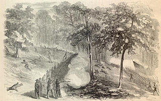
The Battle of Crampton's Gap, or Battle of Burkittsville, was a battle fought between forces under Confederate Brig. Gen. Howell Cobb and Union Maj. Gen. William B. Franklin as part of the Battle of South Mountain on September 14, 1862, at Crampton's Gap in Western Maryland, during the Maryland Campaign of the American Civil War.

Samuel Garland Jr. was an American attorney from Virginia and Confederate general during the American Civil War. He was killed in action during the Maryland Campaign while defending Fox's Gap at the Battle of South Mountain.

America's 11 Most Endangered Places or America's 11 Most Endangered Historic Places is a list of places in the United States that the National Trust for Historic Preservation considers the most endangered. It aims to inspire Americans to preserve examples of architectural and cultural heritage that could be "relegated to the dustbins of history" without intervention.
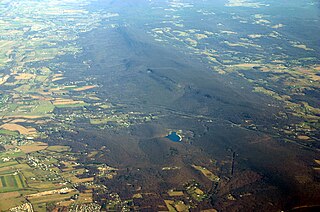
South Mountain is the northern extension of the Blue Ridge Mountain range in Maryland and Pennsylvania. From the Potomac River near Knoxville, Maryland in the south to Dillsburg, Pennsylvania in York County, Pennsylvania in the north, the 70-mile-long (110 km) range separates the Hagerstown and Cumberland valleys from the Piedmont regions of the two states.

Gathland State Park is a public recreation area and historic preserve located on South Mountain near Burkittsville, Maryland, in the United States. The state park occupies the former estate of war correspondent George Alfred Townsend (1841-1914), who wrote under the pen name "Gath" during the American Civil War. The estate's few remaining original structures include the War Correspondents Memorial Arch, which sits alongside the Appalachian Trail. The park is operated by the Maryland Department of Natural Resources. The arch is a National Historic Monument maintained by the National Park Service.

The Business and Government Historic District is a historic district in downtown Baltimore, Maryland, United States, that was listed on the National Register of Historic Places in 1987. The district comprises the center of Baltimore's municipal government and the eastern portion of Baltimore's commercial district. The major feature of the district is the War Memorial Plaza with City Hall to the west and the War Memorial to the east.
The Burkittsville Historic District comprises the small town of Burkittsville, Maryland. Located at a crossroads in western Frederick County, the town is a consistent collection of early 19th-century Federal style houses mixed with a few Victorian style houses that has remained virtually unchanged since 1900. The town is surrounded on three sides by an open, farmed landscape, and nestles against South Mountain on its western side.

Dahlgren Chapel is located at the summit of Turner's Gap in western Maryland between Middletown and Boonsboro. The Gothic revival stone chapel was built in 1881 and consecrated as the Chapel of St. Joseph of the Sacred Heart of Jesus. Most of the building materials came from the immediate area of the site, while a marble altar was imported from Italy.

The historical buildings and structures of Zion National Park represent a variety of buildings, interpretive structures, signs and infrastructure associated with the National Park Service's operations in Zion National Park, Utah. Structures vary in size and scale from the Zion Lodge to road culverts and curbs, nearly all of which were designed using native materials and regional construction techniques in an adapted version of the National Park Service Rustic style. A number of the larger structures were designed by Gilbert Stanley Underwood, while many of the smaller structures were designed or coordinated with the National Park Service Branch of Plans and Designs. The bulk of the historic structures date to the 1920s and 1930s. Most of the structures of the 1930s were built using Civilian Conservation Corps labor.

Fox's Gap, also known as Fox Gap, is a wind gap in the South Mountain Range of the Blue Ridge Mountains, located in Frederick County and Washington County, Maryland. The gap is traversed by Reno Monument Road. The Appalachian Trail also crosses the gap along the ridgeline.

The Crampton's Gap Historic District comprises the battlefield where the American Civil War Battle of Crampton's Gap, part of the larger Battle of South Mountain, took place on September 14, 1862. The district extends on the west to the foot of South Mountain, and to the east of Burkittsville, beyond the eastern foot of the mountain. The district is characterized by steep mountain terrain in the west and open farmland in the east, with the small town of Burkittsville in the center, which is itself listed as a historic district on the National Register of Historic Places. The district extends to the south to include Brownsville Gap. The district includes 98 contributing buildings, 78 of which are in the Burkittsville Historic District. Crampton's Gap at the crest of the mountain is encompassed by Gathland State Park, which features the War Correspondents Memorial Arch, erected in 1896 to memorialize journalists killed in wartime. The arch is listed on the National Register as part of Antietam National Battlefield. The mountainous portions of the district feature numerous stone walls, which were used by both sides for shelter against gunfire during the battle.

Washington Street–Monument Circle Historic District is a national historic district located at Indianapolis, Indiana, United States, covering the first two blocks of East and West Washington and Market streets, the south side of the 100 block of East Ohio Street, Monument Circle, the first block of North and South Meridian Street, the first two blocks of North Pennsylvania Street, the west side of the first two blocks of North Delaware Street, the east side of the first block of North Capitol Avenue, and the first block of North Illinois Street. In total, the district encompasses 40 contributing buildings and 2 contributing structures in the central business district of Indianapolis centered on Monument Circle. It developed between about 1852 and 1946, and includes representative examples of Italianate, Greek Revival, and Art Deco style architecture.


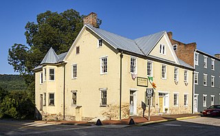
 Old South Mountain Inn at Turner's Gap

