
The Carnarvon xeric shrublands is a deserts and xeric shrublands ecoregion of Western Australia. The ecoregion is coterminous with the Carnarvon Interim Biogeographic Regionalisation for Australia (IBRA) bioregion.

Cape Leeuwin is the most south-westerly mainland point of the Australian continent, in the state of Western Australia.
St Alouarn Islands are a group of islands and rocks south-east of Cape Leeuwin in Western Australia, approximately 11 km south of Augusta in Flinders Bay.

The Ningaloo Coast is a World Heritage Site located in the north west coastal region of Western Australia. The 705,015-hectare (1,742,130-acre) heritage-listed area is located approximately 1,200 kilometres (750 mi) north of Perth, along the East Indian Ocean. The distinctive Ningaloo Reef that fringes the Ningaloo Coast is 260 kilometres (160 mi) long and is Australia's largest fringing coral reef and the only large reef positioned very close to a landmass. The Muiron Islands and Cape Farquhar are within this coastal zone.
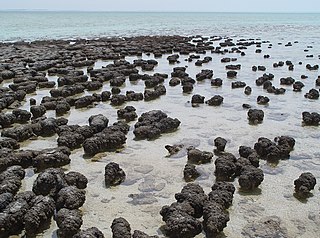
The Hamelin Pool Marine Nature Reserve is a protected marine nature reserve located in the UNESCO World Heritage–listed Shark Bay in the Gascoyne region of Western Australia. The 127,000-hectare (310,000-acre) nature reserve boasts the most diverse and abundant examples of living marine stromatolites in the world, monuments to life on Earth over 3,500 million years BP.

Investigator Strait is a body of water in South Australia lying between the Yorke Peninsula, on the Australian mainland, and Kangaroo Island. It was named by Matthew Flinders after his ship, HMS Investigator, on his voyage of 1801–1802. It is bordered by the Gulf St Vincent in the northeast.

Nuytsland Nature Reserve is a protected area of Western Australia in the south-eastern part of the state, on the south coast.

Wedge Island is a 400-metre long wedge shaped island north of Lancelin and south of Cervantes on the Western Australian coast. The island is located just south of “the point” and approximately 15km south-east of an informal settlement known as Grey village with which it often shares a name. Both are within the Shire of Dandaragan.
Western Australia has the longest coastline of any state or territory in Australia, at 10,194 km or 12,889 km. It is a significant portion of the coastline of Australia, which is 35,877 km.
The south coast of Western Australia comprises the Western Australian coastline from Cape Leeuwin to Eucla. This is a distance of approximately 1,600 kilometres (1,000 mi), fronting the Great Australian Bight and the Southern Ocean.

The Jurien Bay Marine Park is a protected marine park that is located 200 to 300 kilometres north of Perth, off the coastal tip of the Wheatbelt region of Western Australia. The 82,375-hectare (203,550-acre) marine park was formally declared on 31 August 2003 and is situated along the Indian Ocean Drive that extends south from Green Head to the southern boundary of Nambung National Park. It includes many of the islands located in this region.
Kimberley coastline (Western Australia) is a coastal region at the ocean edges of the Kimberley land region in the northern part of Western Australia.

Nepean Bay is a bay located on the north-east coast of Kangaroo Island in the Australian state of South Australia about 130 kilometres south-south-west of Adelaide. It was named by the British navigator, Matthew Flinders, after Sir Evan Nepean on 21 March 1802.

Anxious Bay is a bay in the Australian state of South Australia located on the west coast of Eyre Peninsula about 275 kilometres west north-west of Adelaide. It was named by Matthew Flinders on 21 February 1802. It is one of four ‘historic bays’ located on the South Australian coast.

Escape Island is an island near Jurien Bay in Western Australia. It is located within the Jurien Bay Marine Park and part of the Escape Island Nature Reserve.
Whitlock Island is an island near Jurien Bay in Western Australia. It is located within the Jurien Bay Marine Park and part of the Boullanger, Whitlock, Favourite, Tern and Osprey Islands Nature Reserve.

Favorite Island is an island near Jurien Bay in Western Australia.
Batavia Coast is a name attributed to a section of the coastline of Western Australia, in the region close to the vicinity of the site of the wreck of the Batavia in the Abrolhos Islands.
The Cervantes Islands are a small group of islands in Western Australia, found to the south west of the locality of Cervantes. They are approximately 180km north west of Perth. They are 2 km (1.2 mi) from Thirsty Point which is at the southern side of the locality.
This page is based on this
Wikipedia article Text is available under the
CC BY-SA 4.0 license; additional terms may apply.
Images, videos and audio are available under their respective licenses.

