Twyford and Stenson

Last updated

Twyford and Stenson
Derbyshire UK location map.svg
Red pog.svg
Twyford and Stenson
Location within Derbyshire
OS grid reference SK325298
Civil parish
  • Twyford and Stenson
District
Shire county
Region
Country England
Sovereign state United Kingdom
Post town DERBY
Postcode district DE73
Dialling code 01332
Police Derbyshire
Fire Derbyshire
Ambulance East Midlands
UK Parliament
List of places
UK
England
Derbyshire
52°51′58″N1°31′01″W / 52.866°N 1.517°W / 52.866; -1.517 Coordinates: 52°51′58″N1°31′01″W / 52.866°N 1.517°W / 52.866; -1.517

Twyford and Stenson is a civil parish in the South Derbyshire district of Derbyshire, England. Located south of Derby on the Trent and Mersey Canal, it consists of two villages, Stenson and its smaller neighbour Twyford.

Contents

Between Stenson and Derby itself lies the busy A50 dual-carriageway and Stenson Fields, a large housing estate built between the early 1970s and late 1990s. Stenson Fields is constituted as a separate parish wholly within South Derbyshire District, but it is essentially contiguous with the Sunny Hill, Sinfin and Littleover suburbs of Derby city. The parish of Stenson Fields was created in 1983 from parts of the parish of Barrow-upon-Trent and the parish of Twyford and Stenson. Originally called Sinfin Moor the name was later changed to Stenson Fields to be in keeping with the geographical and historical place name of the area. Sinfin Moor is a large tract of land to the east of Stenson Fields and Sinfin proper. Sinfin Moor is a Regionally Important Geological Site (RIGS) which formed over the bed of an ice age lake. Part of the RIGS spills over into Stenson Fields close to the hamlet of Arleston. In 2017, South Derbyshire District Council described Twyford and Stenson as an "unparished area" when it approved the transfer of a further 197 acres from it to Stenson Fields parish. In 2020, Twyford and Stenson does not appear to have a parish council. [1]

The overflow emerging into the canal at the lower left is known as The Bubble Stenson Bubble.jpg
The overflow emerging into the canal at the lower left is known as The Bubble
Trent & Mersey Canal at Stenson Lock. Loop line (note wagons) is on left beyond hedge. Marina is on right Stenson derby.jpg
Trent & Mersey Canal at Stenson Lock. Loop line (note wagons) is on left beyond hedge. Marina is on right

Stenson Lock is lock number 6. It is the second deepest on the canal at 12' 6". [2] There is also a marina and a narrowboat builders. The 'Stenson Bubble', after which the local waterside pub is named, is due to the sound, and actual bubbles, the overflow stream to the south of the lock makes as it emerges forcefully into the canal below the lock through a culvert at the same level, or sometimes below, the canal surface itself.

A railway line follows the line of the canal, part of a loop for freight bypassing Derby. This runs from the nearby Stenson Junction on the Derby-Birmingham line to Sheet Stores Junction at Sawley on the Midland Main Line.

Twyford

'The River Trent seen from Twyford' TwyfordRiverTrent8.JPG
'The River Trent seen from Twyford'

Stenson itself is parished with Twyford, (grid reference SK327285 ). a similar village about one mile (1.6 km) to the south, on the north bank of the River Trent.

Twyford and Stenson are mentioned in 1086 in the Domesday book. The book says [4] under the title of “The lands of Henry de Ferrers [5]

”In Twyford and Stenson Leofric had four carucates of land to the geld. There is land for three ploughs (plows). There are now two ploughs in demesne and four villans and five bordars with one plough and one mill rendering 5 shillings have one plough. There is one mill rendering 2 shillings and 24 acres (97,000 m2) of meadow, woodland pasture one furlong long and one much broad. TRE [6] worth eight pounds now four pounds.“

St Andrew's Church at Twyford is an unusual sight as from the outside it appears to be of brick construction with stone extensions and steeple. In fact the brickwork is just a fascia as internal investigation reveals. It is about 220 yards (200 m) from the River Trent which floods every winter but never, it seems, has the church been flooded. [7] However it has been damaged by lightning in 1821 and a fire in 1910. The lower part of the tower dates from 1200. Local tradition tells of food being handed out to wayfarers from a stone-framed window in a nearby farmhouse. This charity was administered by monks from a religious house of the Knights Hospitallers at the village of Arleston.

Twyford Ferry

Twyford Ferry 1899 Twyford Ferry 1899.jpg
Twyford Ferry 1899

The river crossing at Twyford was mentioned in 1712, and again in 1790, when it could carry two horses. The chain ferry linked the village with Milton on the far side of the river saving a long detour via Swarkestone Bridge. Floods after the thaw of the Winter of 1963, saw the ferryboat swept away, and it was never reinstated. The ferry posts that supported the chain, still remain on both sides of the river. [8]

See also

Related Research Articles

<span class="mw-page-title-main">South Derbyshire</span> Non-metropolitan district in England

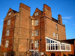
South Derbyshire is a local government district in Derbyshire, England. The population of the local authority at the 2011 Census was 94,611. It contains a third of the National Forest, and the council offices are in Swadlincote. The district also forms part of the wider Burton upon Trent and Swadlincote Green Belt, which covers the towns of Burton-upon-Trent in East Staffordshire and Swadlincote in South Derbyshire. The district is also landlocked between the districts of Derby, Derbyshire Dales, East Staffordshire, Erewash District, Lichfield District, North Warwickshire, North West Leicestershire and Tamworth.

<span class="mw-page-title-main">Chellaston</span> Human settlement in England

Chellaston is a suburban village on the southern outskirts of Derby, in Derbyshire, England.

<span class="mw-page-title-main">Aston-on-Trent</span> Human settlement in England

Aston-on-Trent is a village and civil parish in the South Derbyshire district, in the county of Derbyshire, England. The parish had a population of 1,682 at the 2011 Census. It is adjacent to Weston-on-Trent and near Chellaston, very close to the border with Leicestershire.

<span class="mw-page-title-main">Willington, Derbyshire</span> Human settlement in England

Willington is a village and civil parish in the South Derbyshire district of Derbyshire, England. The 2001 Census recorded a parish population of 2,604, increasing to 2,864 at the 2011 Census.

<span class="mw-page-title-main">Alvaston</span> Human settlement in England

Alvaston is a village and ward of Derby, England. Alvaston is situated on the A6, three miles south-east of Derby city centre and probably owes its name to Allwald. It is bordered to the north by the wards of Derwent, Chaddesden and Spondon, to the west is the City Centre, to the south are Sinfin and Chellaston and to the east the district of South Derbyshire.

<span class="mw-page-title-main">Weston-on-Trent</span> Village in Derbyshire, England

Weston-on-Trent is a village and civil parish in the South Derbyshire district of Derbyshire. The population of the civil parish at the 2011 census was 1,239. It is to the north of the River Trent and the Trent and Mersey Canal. Nearby places include Aston-on-Trent, Barrow upon Trent, Castle Donington and Swarkestone.

<span class="mw-page-title-main">Barrow upon Trent</span> Village and civil parish in the South Derbyshire district of Derbyshire, England

Barrow upon Trent is a village and civil parish in the South Derbyshire district of Derbyshire, England with a business park planned for the outskirts of the village. The village is south of Derby, and between the River Trent and the Trent and Mersey Canal. According to the 2001 census the parish had a population of 546, increasing to 558 at the 2011 Census. Nearby places are Sinfin, Ingleby, Arleston, and Swarkestone.

Swarkestone is a village and civil parish in the South Derbyshire district of Derbyshire, England. The population at the 2011 Census was 187.

<span class="mw-page-title-main">Morley, Derbyshire</span> Human settlement in England

Morley is a village and civil parish within the Borough of Erewash in Derbyshire, England.

Sunny Hill is a southern suburb of the city of Derby, England, situated mainly along the Stenson Road. It lies between the Derby City districts of Normanton and Littleover, and, to the south, Sinfin, and the parish of Stenson Fields in South Derbyshire district.

<span class="mw-page-title-main">Stenson Fields</span> Human settlement in England

Stenson Fields is a semi-rural suburban housing development and civil parish in the South Derbyshire district of Derbyshire, England. The parish is contiguous with Sinfin, a southern area of Derby, but is outside the city boundary. Stenson Fields is located approximately 3 miles (4.8 km) south-southwest of Derby city centre. The housing in the area largely dates from the 1970s onwards.

<span class="mw-page-title-main">Sinfin</span> Human settlement in England

Sinfin is a suburb of Derby, England, 3 miles (4.8 km) southwest of the city centre on its southern outskirts. The ward, which includes Osmaston as well as Sinfin itself, had a population of 15,128 in 2011. Historically, Sinfin and Osmaston were separate villages before being swallowed up by the expansion of Derby. Osmaston is characterised by inter-war housing developments while much of the housing in Sinfin is post-war. Between the two suburbs lies a more industrialised area dominated by the Rolls-Royce works.

<span class="mw-page-title-main">Arleston</span> Human settlement in England

Arleston is a hamlet in the South Derbyshire district of Derbyshire, England, about 4 miles (6.4 km) south of the centre of Derby. It is located 1.2 miles (1.9 km) northwest of Barrow upon Trent and is part of that village's civil parish. The Trent and Mersey Canal passes through Arleston.

<span class="mw-page-title-main">Dalbury Lees</span> Human settlement in England

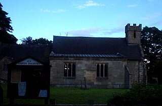
Dalbury Lees is a parish in south Derbyshire. The population of the civil parish as taken at the 2011 Census was 306. It is about six miles (10 km) from both Burton-on-Trent and Derby and just under four miles (6 km) from Egginton. The parish contains the villages of Dalbury and Lees which are just under 2 miles (3.2 km) apart from one another. Dalbury Lees has been known as Dalbury and as Dalbury with Lees, but Dalbury Lees is the preferred term

<span class="mw-page-title-main">Sutton on the Hill</span> Human settlement in England

Sutton-on-the-Hill is a parish in south Derbyshire eight miles (13 km) west of Derby. The population of the civil parish taken at the 2011 Census was 123. The village is widely spread out and contains both a church and a chapel. It was described as "a parish, with two townships and a hamlet" in the 1870s. Now it has no shop or post office and limited public transport links. Sutton on the Hill is primarily an agricultural area with former dairy farms at either end of the village, along with the Sutton Estate Farm. The village school has been converted into a village hall and has a nursery school for the local villages.

<span class="mw-page-title-main">Shottle</span> Human settlement in England

Shottle is a village approximately 3 miles (4.8 km) south of the market town of Wirksworth in Derbyshire. The population of the civil parish at the 2011 Census was 266.

<span class="mw-page-title-main">St Andrew's Church, Twyford</span> Church in Derbyshire, England

St Andrew’s Church, Twyford is a Grade I listed parish church in the Church of England in Twyford, Derbyshire.

The Hundreds of Derbyshire were the geographic divisions of the historic county of Derbyshire for administrative, military and judicial purposes. They were established in Derbyshire some time before the Norman conquest. In the Domesday Survey of 1086 AD the hundreds were called wapentakes. By 1273 the county was divided into 8 hundreds with some later combined, becoming 6 hundreds over the following centuries. The Local Government Act 1894 replaced hundreds with districts. Derbyshire is now divided into 8 administrative boroughs within the Derbyshire County Council area.

Twyford and Stenson is a civil parish in the South Derbyshire district of Derbyshire, England. The parish contains twelve listed buildings that are recorded in the National Heritage List for England. Of these, one is listed at Grade I, the highest of the three grades, one is at Grade II*, the middle grade, and the others are at Grade II, the lowest grade. The parish contains the villages of Twyford and Stenson and the surrounding countryside. The Trent and Mersey Canal runs through the north of the parish, and the listed buildings associated with it are bridges, a lock and a cottage. The other listed buildings are a church, houses, cottages and associated structures, and farmhouses and farm buildings.

References

  1. South Derbyshire District Council
  2. Deepest Canal Locks in England and Wales
  3. Pictures from Wikimedia Commons
  4. Domesday Book: A Complete Translation. London: Penguin, 2003. ISBN   0-14-143994-7 p.749
  5. Henry held a considerable number of manors including several in Derbyshire given to him by the King. These included obviously Twyford and Stenson, but also included lands in Youlgreave, Swarkestone and Kedleston.
  6. TRE in Latin is Tempore Regis Edwardi. This means in the time of King Edward before the Battle of Hastings.
  7. ”The Church of St Andrew Twyford” An eight page brochure published by the church. Available May 2007
  8. "Twyford" (PDF). SDDC. 2009. Retrieved 7 January 2019.