A lighthouse is a tower, building, or other type of physical structure designed to emit light from a system of lamps and lenses and to serve as a beacon for navigational aid for maritime pilots at sea or on inland waterways.

Cape Hatteras Light is a lighthouse located on Hatteras Island in the Outer Banks in the town of Buxton, North Carolina and is part of the Cape Hatteras National Seashore. It is the tallest lighthouse in the U.S. from base to tip at 210 feet. The lighthouse's semi-unique pattern makes it easy to recognize and famous. It is often ranked high on lists of most beautiful, and famous lighthouses in the US.

The Sabine Pass Lighthouse, or Sabine Pass Light as it was referred to by the United States Coast Guard, is a historic lighthouse, as part of a gulf coast light station, on the Louisiana side of the Sabine River, in Cameron Parish, across from the community of Sabine Pass, Texas. It was first lit in 1857 and was deactivated by the Coast Guard in 1952. One of only three built in the United States of similar design, the light was listed on the National Register of Historic Places as "Sabine Pass Lighthouse" on December 17, 1981. It is now abandoned but has long continued to be the subject of preservation efforts.
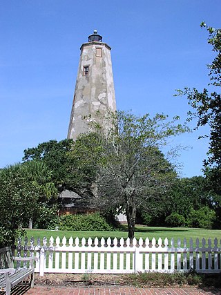
Bald Head Lighthouse, known as Old Baldy, is the oldest lighthouse still standing in North Carolina. It is the second of three lighthouses that have been built on Bald Head Island since the 18th century to help guide ships past the dangerous shoals at the mouth of the Cape Fear river.

The Two Harbors Light is the oldest operating lighthouse in the US state of Minnesota. Overlooking Lake Superior's Agate Bay, the lighthouse is located in Two Harbors, Minnesota. The construction of the lighthouse began in 1891 and was completed the following year, with the light being lit for the first time on April 14, 1892. The first Two Harbors keeper was Charles Lederle and there were normally three keepers assigned to make sure the light was lit every day. The Lighthouse was built to provide safe passage into the Agate Bay Harbor during the early 20th century, as Two Harbors was a major shipping point for the iron ore of the Mesabi Range.
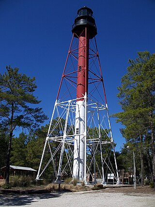
The Crooked River Light, also known as the Carrabelle Light, was built in 1895 to replace the Dog Island Light on Dog Island, which had been destroyed in 1875 by a hurricane. The location on the mainland allowed the light to serve as the rear range light for the channel to the west of Dog Island, used by ships in the lumber trade.

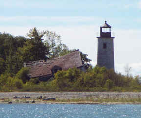
The New Presque Isle Light was built in 1870, at Presque Isle, Michigan, east of Grand Lake, and sits on the namesake peninsula. It is one of 149 lighthouses in Michigan, more than any other state. Because of changing shoreline particularly, or alternatively deterioration of the original building, it is not uncommon for a replacement lighthouse to be placed in the vicinity of an earlier light, in this case, the Old Presque Isle Light.

The Cape Lookout Lighthouse is a 163-foot-high lighthouse located on the southern Outer Banks of North Carolina. It flashes every 15 seconds and is visible at least 12 miles out to sea and up to 19 miles. It is one of the very few lighthouses that operate during the day. It became fully automated in 1950. The Cape Lookout Lighthouse is the only such structure in the United States to bear the checkered daymark, intended not only for differentiation between similar light towers, but also to show direction. The center of the black diamonds points in a north-south direction, while the center of the white diamonds points east-west.
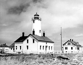
The New Dungeness Lighthouse is a functioning aid to navigation on the Strait of Juan de Fuca, located on the Dungeness Spit in the Dungeness National Wildlife Refuge near Sequim, Clallam County, in the U.S. state of Washington. It has been in continuous operation since 1857, although the current lighthouse tower is 26 feet (7.9 m) shorter than when first constructed.

Alcatraz Island Lighthouse is a lighthouse—the first one built on the U.S. West Coast—located on Alcatraz Island in California's San Francisco Bay. It is located at the southern end of the island near the entrance to the prison. The first light house on the island was completed in 1854, and served the bay during its time as a Citadel and military prison. It was replaced by a taller concrete tower built in 1909 to the south of the original one which was demolished after it was damaged due to earthquake in 1906. The automation of the lighthouse with a modern beacon took place in 1963, the year Alcatraz closed as the Alcatraz Federal Penitentiary. It is the oldest light station on the island with a modern beacon and is part of the museum on the island. Although when viewed from afar it easily looks the tallest structure on Alcatraz, it is actually shorter than the Alcatraz Water Tower, but as it lies on higher ground it looks much taller.
Charity Island Light is a lighthouse on Big Charity Island in Lake Huron just off the coast of Au Gres, Northern Michigan.

The St. Simons Island Light is a lighthouse on the southern tip of St. Simons Island, Georgia, United States. It guides ships into St. Simons Sound and warns of the many sandbars in the area.

Ashtabula Harbor Light is a lighthouse in Ashtabula, Ohio. It was listed in the National Register on August 8, 1983.
The White Shoal Light is a lighthouse located 20 miles (32 km) west of the Mackinac Bridge in Lake Michigan. It is an active aid to navigation. It is also the tallest lighthouse on the Great Lakes.

The Ontonagon Light is a lighthouse located off M-64 near Ontonagon, Michigan. It was listed on the National Register of Historic Places in 1975 and designated a Michigan State Historic Site in 1973.
Chester Rock Light was a light in Chester, Connecticut on the Connecticut River. It was built in 1889 as part of a $15,000 appropriation by the United States Congress. The 21-foot tall wooden hexagonal pyramidal tower had a black lantern with a 6th order Fresnel lens. The light was first lit on July 1, 1889. The tower was replaced in 1912 by a skeleton tower that was subsequently modified in 1927. Records do not show the deactivation or destruction of the light, but it was believed to have been removed in the 1930s. In the 1990s, the Deep River Historical Society of Deep River, Connecticut wanted to build a replica of the structure for use as a daymark.
The Essex Reef Light or Essex Reef Post Light, also known as Hayden's Point Light, was a light in Essex, Connecticut on the Connecticut River. The 21-foot (6.4 m) wooden tower was erected in 1889 and replaced with a skeleton tower by 1919. The skeleton tower was further altered to an automatic gas light a few years prior to 1931. Its keeper, Gilbert Burnett "Bernie" Hayden served for 30 years. As of 2014, a 26-foot (7.9 m) skeleton tower serves as an active daymark and it has a green flash every 4 seconds.
The Chantry Island Lighthouse, officially known as Chantry Island Lightstation Tower, is a lightstation on Chantry Island, off the coast of Southampton, Ontario in Lake Huron. It was constructed in the years 1855 through to 1859, by John Brown of Thorold, Ontario, under the authority of the Province of Canada and is recognized as one of the six Imperial Towers. Virtually identical, they were completed in 1858-1859 on Lake Huron and Georgian Bay and are among the few lighthouses on the Great Lakes made of cut limestone and granite.

The Pass A L'Outre Light is a defunct lighthouse in the Birdfoot Delta in Louisiana, United States, located near the mouth of the Mississippi River. Erected to mark the then-active entrance to the river, it was abandoned as that channel silted up. It has been in the path of several noteworthy hurricanes, and was heavily damaged. It is on the Lighthouse Digest Doomsday List, and is critically in danger. The lighthouse is at the center of a nature preserve.
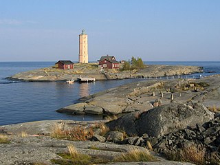
The Söderskär lighthouse is a decommissioned 19th-century lighthouse in the outer Porvoo archipelago of the Gulf of Finland. It was built in 1862, replacing an earlier unilluminated daymark, automated in 1957, and decommissioned in 1989.