
The 1964 Pacific typhoon season was the most active tropical cyclone season recorded globally, with a total of 39 tropical storms forming. It had no official bounds; it ran year-round in 1964, but most tropical cyclones tend to form in the northwestern Pacific Ocean between June and December. These dates conventionally delimit the period of each year when most tropical cyclones form in the northwestern Pacific Ocean.

The 1951 Pacific typhoon season was a generally average season with multiple tropical cyclones striking the Philippines. With the exception of January, each month saw at least one tropical system develop; October was the most active month with four tropical cyclones forming. Overall, there were 31 tropical depressions, of which 25 became tropical storms; of those, there were 16 typhoons.

The 2019 Pacific typhoon season was the costliest Pacific typhoon season on record, just ahead of the previous year and 2023. The season featured fairly above-average tropical cyclone activity for the second consecutive year, producing 29 named storms, 17 typhoons, and five super typhoons. The season's first named storm, Pabuk, reached tropical storm status on January 1, becoming the earliest-forming tropical storm of the western Pacific Ocean on record, breaking the previous record that was held by Typhoon Alice in 1979. The season's first typhoon, Wutip, reached typhoon status on February 20. Wutip further intensified into a super typhoon on February 23, becoming the strongest February typhoon on record, and the strongest tropical cyclone recorded in February in the Northern Hemisphere. The season's last named storm, Phanfone, dissipated on December 29 after it made landfall in the Philippines.

In September 1934, a violent typhoon caused tremendous devastation in Japan, leaving more than 3,000 people dead in its wake. Dubbed the Muroto typhoon, the system was first identified on September 13 over the western Federated States of Micronesia. Moving generally northwest, it eventually brushed the Ryukyu Islands on September 20. Turning northeast, the typhoon accelerated and struck Shikoku and southern Honshu the following morning. It made landfalls in Muroto, Kaifu, Awaji Island, and Kobe. A pressure of 911.9 hPa (26.93 inHg) was observed in Muroto, making the typhoon the strongest ever recorded to impact Japan at the time. This value was also the lowest land-based pressure reading in the world on record at the time; however, it was surpassed the following year during the 1935 Labor Day hurricane. After clearing Japan, the now extratropical storm traveled east and weakened. Turning north by September 24, the system deepened and impacted the Aleutian Islands; it was last noted the following day over western Alaska.

Typhoon Bart, known in the Philippines as Typhoon Oniang, was a powerful and destructive typhoon that occurred during the 1999 Pacific typhoon season. It was the only super typhoon of that year. Bart reached "super typhoon" status on September 22, when it grew to comprise winds containing a force of 260 km/h (160 mph).

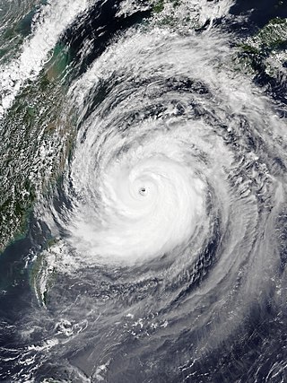
Typhoon Ida, also known as the Kanogawa Typhoon, was the sixth-deadliest typhoon to hit Japan, as well as one of the strongest tropical cyclones on record. On September 20, Ida formed in the Western Pacific near Guam. It moved to the west and rapidly intensified into a 185 km/h (115 mph) typhoon by the next day. On September 22, Ida turned to the north and continued its quick rate of intensification. Two days later, the Hurricane Hunters observed a minimum barometric pressure of 877 mb (25.9 inHg), as well as estimated peak winds of 325 km/h (202 mph). This made Ida the strongest tropical cyclone on record at the time, although it was surpassed by Typhoon June 17 years later. Ida weakened as it continued to the north-northeast, and made landfall in Japan on southeastern Honshū with winds of 130 km/h (80 mph) on September 26. It became extratropical the next day, and dissipated on the September 28 to the east of the country. Ida caused torrential flooding to southeastern Japan, resulting in over 1,900 mudslides. Damage was estimated at $50 million, and there were 1,269 fatalities.

Typhoon Tess was a typhoon that caused great damage to Japan in September 1953 while Japan was still in the middle of post-war recovery. The name 'Typhoon Tess' has been attributed to eleven other tropical cyclones.

Typhoon Charlotte was a damaging typhoon that struck Okinawa during the 1959 Pacific typhoon season. An area of low pressure developed in early October, and it became a tropical depression on October 9. The depression strengthened to a tropical storm one day later, and it received the name Charlotte from the Joint Typhoon Warning Center (JTWC). The system strengthened quickly and became a typhoon eighteen hours later. Charlotte continued to rapidly strengthen to its peak of 260 km/h (160 mph) on October 13. The typhoon began to weaken afterwards, and it traveled south of Okinawa on October 16. The typhoon weakened to a tropical storm on October 19 as it began its extratropical transition. The storm became extratropical later that day, and the Japan Meteorological Agency (JMA) ceased tracking the system on October 20.

Typhoon Emma was a strong typhoon that struck Okinawa during the 1959 Pacific typhoon season. An area of severe weather formed near Kwajalein Atoll on October 30, and the Japan Meteorological Agency (JMA) began tracking it as a tropical depression on November 1. The Joint Typhoon Warning Center followed suit on November 5 after finding a closed circulation, and the depression received the name Emma. The depression strengthened into a tropical storm west of Guam on November 6 and gradually gained strength. Emma became a typhoon on November 11 near Luzon, and it reached its peak sustained winds of 205 km/h; 125 mph (110 kn) later that day. The typhoon turned northeastwards and grazed Okinawa the next day. Emma steadily weakened and became extratropical on November 13, and the JMA ceased tracking the storm on November 15.

Typhoon Jebi, known in the Philippines as Super Typhoon Maymay, was the costliest typhoon in Japan's history in terms of insured losses. Jebi formed from a tropical disturbance south-southwest of Wake Island on August 26 and became the twenty-first named storm of the 2018 Pacific typhoon season on August 27. Amid favorable environmental conditions, Jebi quickly strengthened into a typhoon on August 29 as it headed west and rapidly intensified as it passed the Northern Mariana Islands on August 30. Jebi reached its peak intensity as a Category 5-equivalent typhoon on August 31, with 10-minute sustained winds of 195 km/h (120 mph), 1-minute sustained winds of 285 km/h (180 mph), and a minimum pressure of 915 hPa. Afterwards, Jebi began a slow weakening trend as it turned northwest, briefly passing through the Philippine Area of Responsibility on September 2. Jebi accelerated north-northeast towards Japan on September 3 as it interacted with the westerlies, and made landfalls over Shikoku and near Kobe early on September 4. Jebi quickly weakened over land and became an extratropical cyclone later that day over the Sea of Japan. Its remnants moved over the Russian Far East before dissipating on September 9.
Severe Tropical Storm Ampil, known in the Philippines as Severe Tropical Storm Inday, was a tropical cyclone that caused moderate damage in the Ryukyu Islands and East and Northeast China in late July 2018. The tenth named storm of the annual typhoon season, Ampil developed into a tropical depression east of Luzon on July 17. The system gradually strengthened over the following days amid a marginally favorable environment and became a severe tropical storm late on July 19 as it moved northwest. Maintaining its strength, Ampil passed over Okinawa Island from July 20 to 21. Thereafter, Ampil weakened slightly while crossing the East China Sea, before making landfall in Shanghai, China, on July 22. The system weakened slowly over land and degraded to a tropical depression on July 23. The system turned eastwards as it continued weakening over land, diminishing to a remnant low on July 25 and dissipating fully a day later over the Russian Far East.

Typhoon Faxai, known in Japan as Reiwa 1 Bōsō Peninsula Typhoon, was the first typhoon to strike the Kantō region since Mindulle in 2016, and the strongest typhoon to hit the region since Ma-on in 2004. It was also the worst to hit the region since Talas in 2011, until the region was hit by more destructive Typhoon Hagibis less than a month later. Forming as the fifteenth named storm of the 2019 Pacific typhoon season, the precursor to Faxai was first noted as a weak tropical depression to the east of the International Dateline on August 29. The depression then entered the West Pacific basin on August 30. After moving in a general westward direction, the system strengthened into a named tropical storm by September 5. Faxai then strengthened into the sixth typhoon of the season the next day. Two days later, Faxai reached its peak strength as a Category 4 typhoon just before making landfall in mainland Japan. Turning northeastward, Faxai rapidly weakened and became extratropical on September 10.
Typhoon Maysak, known in the Philippines as Typhoon Julian, was a deadly, damaging and powerful tropical cyclone that struck the Ryukyu Islands and the Korean Peninsula in September 2020. The third typhoon of the 2020 Pacific typhoon season, Maysak formed from a tropical disturbance. The disturbance gradually organized, receiving the name Julian from PAGASA as it became a tropical depression. As the depression strengthened, the JMA subsequently named the system Maysak. Maysak rapidly intensified into a strong typhoon before weakening and making landfall in South Korea.

Typhoon Jane was a catastrophic and deadly tropical cyclone that left significant effects to Japan during the 1950 Pacific typhoon season. It caused over 398 reported deaths and 141 to be missing, mainly due to the landslides and flooding. It also destroyed some battle and cargo ships. The sixth reported typhoon of the season, Jane was first mentioned in weather maps as a tropical depression to the east of the Philippines. It quickly strengthened to a tropical storm as it moved to the northwest. It then curved to the northeast, reaching its peak intensity of 185 km/h before weakening and striking Minami in Tokushima Prefecture on September 3 as a Category 2 typhoon. It quickly weakened, passing through the Awaji Island and Kobe before becoming extratropical in the Sea of Japan on the same day. The extratropical remnants of the system persisted until it was no longer tracked on September 7.

Typhoon Dinah was a tropical cyclone that brought heavy damages to Japan, while leaving 65 fatalities and 70 to be missing, all in that country alone. It is also one of the disasters that happened in the country during the Showa 27 era. The second typhoon of the 1952 Pacific typhoon season, Dinah was first mentioned in weather maps as a tropical depression to the east of Visayas. It gradually organized, becoming a tropical storm on June 21 as it skirted the northeastern Philippines, with the Fleet Weather Center naming it Dinah. It strengthened further to a minimal typhoon as it moved through the Nansei Islands on June 22, before reaching its peak intensity of 140 km/h, as estimated by the Fleet Center. It then weakened shortly, before passing near Shikoku on the next day, then making landfall through the southern part of the Kii Peninsula before gradually weakened further and started to undergo extratropical transition as it moved out of the country on June 24. It then became fully extratropical on the next day.

Severe Tropical Storm Maliksi, known in the Philippines as Severe Tropical Storm Domeng, was a tropical cyclone in June 2018 that brought rainfall to the Philippines and Japan. It caused 2 deaths and prompted the PAGASA to declare the beginning of the rainy season in the Philippines. The fifth named storm and 4th tropical cyclone in the Philippine Area of Responsibility (PAR), it was first noted as an area of convection in the South of Palau on May 31.

Typhoon Louise, known in Japan as the Akune Typhoon, was a deadly and destructive tropical cyclone that hit Japan in October 1945, soon after the cessation of World War II. It caused at least 377 deaths and another 74 missing persons, while leaving a wide swath of damage across the country.

Typhoon Ione was a catastrophic and deadly tropical cyclone that left over 512 confirmed deaths and another 326 to be missing as it affected Japan, with the majority of the fatalities coming from the city of Ichinoseki in Iwate Prefecture. It also left a significant trail of damage on the country, just after Typhoon Kathleen devastated the area. The fourteenth named storm and the ninth typhoon of the 1948 Pacific typhoon season, Ione was first seen in weather maps as a tropical storm near the Mariana Islands on September 11. It moved to the northwest, passing through the island country, before strengthening to a typhoon on September 13. It rapidly organized to a Category 4 typhoon and reached its peak intensity on the next day before slowly weakening as it started to approach the Japanese archipelago, while curving to the northeast. It then made landfall on September 16 between the present cities of Tateyama and Kisarazu in Chiba Prefecture as a minimal typhoon. It then passed through the southern coast of Hokkaido, before gradually degraded to a tropical storm as it emerged in the Pacific Ocean on the next day. It then became extratropical, shortly after.
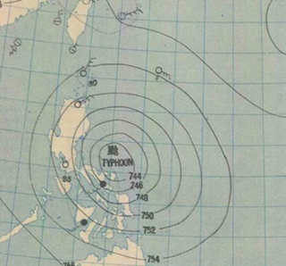
The September 1929 Philippines typhoon was a destructive tropical cyclone that killed over 200 individuals in the Philippine Islands during the 1929 Pacific typhoon season. It was first noted on August 31 to the east of Manila while moving to the west. It then became a typhoon while turning to the west-northwest, hitting the Bicol Region while recording a minimum barometric pressure of 954.62 hPa early the next day on Polillo, Quezon. After crossing the archipelago, it turned to the northwest before dissipating through the weather maps on September 6.

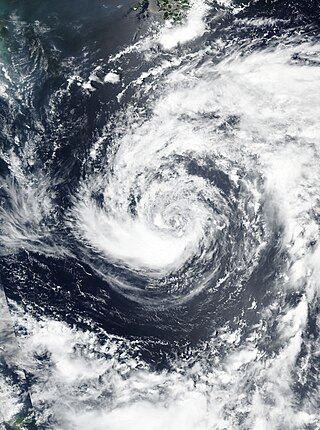
Typhoon Wilda was an intense typhoon that was tied for lowest central pressure of any typhoon in 1964, along with Typhoon Sally. As the twenty-fourth named storm of the season, it origins can be traced back to when it was as a tropical storm east-southeast of Guam on September 16. Wilda moved northwestward for multiple days. it was identified as a tropical storm by Joint Typhoon Warning Center on September 19, strengthening into a typhoon that day. It reached its peak intensity over the Philippine Sea. Wilda slightly weakened following peak strength before curving northward and making landfall on September 24. The storm would eventually emerge into the Sea of Japan and curve northeast. Wilda made a final landfall on September 25 as a tropical storm, thereafter, departing Japan and quickly moving towards the central Aleutian Islands as a powerful extratropical cyclone, dissipating on September 27.


