Tyson McCarter Place

Last updated
Tyson McCarter Place

McCarter-place-tn1.jpg

McCarter smokehouse (left), corn crib (right), and barn (rising beyond)
Location 10 miles east of Gatlinburg on State Route 73 in Great Smoky Mountains National Park
Coordinates 35°45′37.204″N83°18′8.481″W / 35.76033444°N 83.30235583°W / 35.76033444; -83.30235583 Coordinates: 35°45′37.204″N83°18′8.481″W / 35.76033444°N 83.30235583°W / 35.76033444; -83.30235583
Area Less than 1 acre (0.40 ha) [1]
Built circa 1876 [2]
NRHP reference # 76000204
Added to NRHP March 16, 1976 [1]

The Tyson McCarter Place was a homestead located in the Great Smoky Mountains of Sevier County, in the U.S. state of Tennessee. Before the establishment of the Great Smoky Mountains National Park in the 1930s, the homestead belonged to mountain farmer Jacob Tyson McCarter (18781950), a descendant of some of the area's earliest European settlers. While McCarter's house is no longer standing, several outbuildings including a barn, springhouse, corn crib, and smokehouse have survived, and have been placed on the National Register of Historic Places. [1]

Great Smoky Mountains American mountain range along North Carolina/Tennessee border

The Great Smoky Mountains are a mountain range rising along the Tennessee–North Carolina border in the southeastern United States. They are a subrange of the Appalachian Mountains, and form part of the Blue Ridge Physiographic Province. The range is sometimes called the Smoky Mountains and the name is commonly shortened to the Smokies. The Great Smokies are best known as the home of the Great Smoky Mountains National Park, which protects most of the range. The park was established in 1934, and, with over 11 million visits per year, it is the most visited national park in the United States.

Sevier County, Tennessee County in the United States

Sevier County ( "severe") is a county of the U.S. state of Tennessee. As of the 2010 census, the population was 89,889. Its county seat and largest city is Sevierville.

Tennessee State of the United States of America

Tennessee is a state located in the southeastern region of the United States. Tennessee is the 36th largest and the 16th most populous of the 50 United States. Tennessee is bordered by Kentucky to the north, Virginia to the northeast, North Carolina to the east, Georgia, Alabama, and Mississippi to the south, Arkansas to the west, and Missouri to the northwest. The Appalachian Mountains dominate the eastern part of the state, and the Mississippi River forms the state's western border. Nashville is the state's capital and largest city, with a 2017 population of 667,560. Tennessee's second largest city is Memphis, which had a population of 652,236 in 2017.

Contents

The Tyson McCarter Place like the Noah Ogle Place a few miles to the west was once characteristic of the hundreds of small farms that once dotted the isolated coves and valleys of the northern Smokies. McCarter's house and outbuildings were arranged in an unusual circular formation around an open barnyard, probably to allow the livestock maximum protection from wild animals. Another unique feature of the McCarter outbuildings is the adjoined barn and corn crib (these are usually two separate structures). [1] Two chimney falls and the remnants of a foundation mark where McCarter's house once stood, and several well-built rock walls criss-cross the homestead. [2]

Noah Ogle Place

The Noah "Bud" Ogle Place was a homestead located in the Great Smoky Mountains of Sevier County, in the U.S. state of Tennessee. The homestead presently consists of a cabin, barn, and tub mill built by mountain farmer Noah "Bud" Ogle (1863–1913) in the late 19th century. In 1977, the homestead was added to the National Register of Historic Places and is currently maintained by the Great Smoky Mountains National Park.

Location

The Tyson McCarter Place is situated along Webb Creek, which flows northward from its source high up on the slopes of Greenbrier Pinnacle and empties into the Middle Fork of the Little Pigeon River at Pittman Center. The 15.8-mile (25.4 km) Old Settlers Trail crosses the Tyson McCarter Place 3.2 miles (5.1 km) west of the trail's junction with the Maddron Bald Trail (near the Sevier-Cocke county line). An unmarked 0.5-mile (0.80 km) gravel maintenance road (usually gated, but open to foot traffic) connects the Tyson McCarter Place to U.S. Route 321, just west of the Rocky Grove community. With the exception of a small clearing containing the barn, corn crib, and smokehouse, and a small clearing containing the house ruins and springhouse, the area is covered in a dense hardwood forest.

Little Pigeon River (Tennessee) river in Sevier County, Tennessee

The Little Pigeon River is a river located entirely within Sevier County, Tennessee. It rises from a series of streams which flow together on the dividing ridge between the states of Tennessee and North Carolina inside the boundary of the Great Smoky Mountains National Park. The river is subdivided with three separate tributaries: East, Middle, and West.

Pittman Center, Tennessee Town in Tennessee, United States

Pittman Center is a town in Sevier County, Tennessee, United States. The population was 477 at the 2000 census and 502 at the 2010 census, showing an increase of 25.

Maddron Bald Trail

The Maddron Bald Trail is an American hiking trail in the Great Smoky Mountains National Park of Cocke County, Tennessee. Rising from the outskirts of the Cosby community, the trail ascends Maddron Bald, a 5,212-foot (1,589 m) mountain crowned by one of the park's most substantial heath balds. The trail also provides access to Albright Grove, a patch of old growth hardwood forest that contains some of the oldest and tallest trees in the Smokies. The Maddron Bald Trail's terminus— at its junction with the Snake Den Ridge Trail— is just 0.7 miles (1.1 km) from the Appalachian Trail.

Historical structures

Smokehouse Smokehouse-tyson-mccarter-tn1.jpg
Smokehouse

The barn and outbuildings at the Tyson McCarter Place were probably built around 1876 (they were definitely built before 1900) [1] [2] The farm was one of a dozen or so farms that once comprised the Webb Creek community. McCarter's daughter Olive "Ollie" McCarter (19041998) recalled that she, her father, and her sisters built the farm's rock walls, some of which are still standing and run parallel to the Old Settlers Trail for a short distance (rock walls such as these were common in the northern Smokies, where they served the same purpose as barbed-wire fences). [3] The McCarters raised hogs, and used the large barn stalls to house mules. The farm's main crops were corn, rye, wheat, and tobacco. Their farm also included a peach orchard and an apple orchard. [2]

Springhouse Mccarter-springhouse.jpg
Springhouse

The barn is a one-story double-pen rectangular log "drive-through" barn with an attached lean-to corn crib. The side walls of the barn are built of saddle-notched unhewn logs, whereas the front and back walls are built with hewn logs. The barn's gabled roof was originally built with hand-split shingles, and the foundation was originally built of loose stones and logs. The two pens are each 11 feet (3.4 m) by 16 feet (4.9 m), and are separated by an 8-foot (2.4 m) drive-through (wagons were usually parked in the drive-through). [1] The corn crib is built of unhewn saddle-notched logs, and originally included a handmade door secured by a wooden latch. [1]

The smokehouse, used for curing meat, is a one-story structure built of hewn, dove-tail notched logs, measuring 11 feet (3.4 m) by 17 feet (5.2 m). Like the barn, the smokehouse has a gabled roof originally covered with handmade wooden shingles and a foundation of loose stones and logs. The door and storage shelves are missing. [1] The springhouse, used for refrigeration, is a rectangular structure built of hewn chamfer notched logs, measuring 8 feet (2.4 m) by 12 feet (3.7 m). The earthen floor contains a stone trough through which a spring flowed, which kept perishables cool. [1] Two chimney falls, each approximately 9 feet (2.7 m) tall and 30 feet (9.1 m) apart, indicate the former location of the McCarters' house. [2]

See also

Related Research Articles

Cades Cove Valley in the Great Smoky Mountains, Tennessee, USA

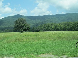
Cades Cove is an isolated valley located in the Tennessee section of the Great Smoky Mountains National Park, USA. The valley was home to numerous settlers before the formation of the national park. Today Cades Cove, the single most popular destination for visitors to the park, attracts more than two million visitors a year because of its well preserved homesteads, scenic mountain views, and abundant display of wildlife. The Cades Cove Historic District is listed on the National Register of Historic Places.

Blackacre Nature Preserve and Historic Homestead building in Kentucky, United States

Blackacre State Nature Preserve is a 271-acre (110 ha) nature preserve and historic homestead in Louisville, Kentucky. The preserve features rolling fields, streams, forests, and a homestead dating back to the 18th century. For visitors, the preserve features several farm animals including horses, goats, and cows, hiking trails, and a visitor's center in the 1844-built Presley Tyler home. Since 1981, it has been used by the Jefferson County Public Schools as the site of a continuing environmental education program. About 10,000 students visit the outdoor classroom each year.

Marble Springs

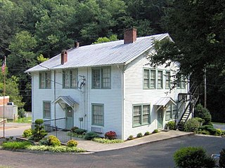
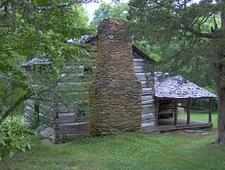
Marble Springs, also known as the Gov. John Sevier Home, is a state historic site in south Knox County, Tennessee, in the southeastern United States. The site was the home of John Sevier (1745–1815)—a Revolutionary War and frontier militia commander and later the first governor of Tennessee—from 1790 until his death in 1815. A cabin at the site was once believed to have been Sevier's cabin, although recent dendrochronological analyses place the cabin's construction date in the 1830s, well after Sevier had died.

The Sugarlands

The Sugarlands is a valley in the north-central Great Smoky Mountains, located in the Southeastern United States. Formerly home to a string of small Appalachian communities, the valley is now the location of the Great Smoky Mountains National Park headquarters and the Sugarlands Visitor Center. Lying just south of Gatlinburg, the Sugarlands is one of the park's most popular access points.

Roaring Fork (Great Smoky Mountains)

Roaring Fork is a stream in the Great Smoky Mountains of Tennessee, located in the Southeastern United States. Once the site of a small Appalachian community, today the stream's area is home to the Roaring Fork Motor Nature Trail and the Roaring Fork Historic District.

Oconaluftee (Great Smoky Mountains) river of North Carolina

Oconaluftee is the name of a river valley in the Great Smoky Mountains of North Carolina, located in the Southeastern United States. Formerly the site of a Cherokee village and Appalachian community, the valley's bottomland is now home to the main entrance to the North Carolina side of the Great Smoky Mountains National Park.

Greenbrier (Great Smoky Mountains) valley in Sevier County, Tennessee

Greenbrier is a valley in the northern Great Smoky Mountains of Tennessee, located in the Southeastern United States. Now a recreational area, Greenbrier was once home to a string of Appalachian communities.

Elmwood-on-the-Opequon building in West Virginia, United States

Elmwood-on-the-Opequon is a farmstead near Kearneysville, West Virginia. The farm complex exemplifies the evolution of a prosperous West Virginia farmstead through the 19th and 20th centuries. The house has expanded around an original log cabin, gradually expanding with major expansions in the 20th century.

Tipton-Haynes State Historic Site Museum and historical site in Tennessee

Tipton-Haynes State Historic Site, known also as Tipton-Haynes House, is a Tennessee State Historic Site located at 2620 South Roan Street in Johnson City, Tennessee. It includes a house originally built in 1784 by Colonel John Tipton, and 10 other buildings, including a smokehouse, pigsty, loom house, still house, springhouse, log barn and corncrib. There is also the home of George Haynes, a Haynes family slave.

Swaggerty Blockhouse

The Swaggerty Blockhouse is a historic structure near Parrottsville, in the U.S. state of Tennessee. The structure was originally believed to have been a frontier blockhouse built by early settler James Swaggerty in 1787. Recent archaeological evidence suggests, however, that the structure was actually a cantilever barn built by a farmer named Jacob Stephens around 1860.

Walker Sisters Place

The Walker Sisters Place was a homestead in the Great Smoky Mountains of Sevier County, in the U.S. state of Tennessee. The surviving structures— which include the cabin, springhouse, and corn crib— were once part of a farm that belonged to the Walker Sisters— five spinster sisters who became local legends due to their adherence to traditional ways of living. The sisters inherited the farm from their father, and after the Great Smoky Mountains National Park was formed in the 1930s, they obtained a lifetime lease. The National Park Service gained control of the property in 1964 when the last Walker sister died. The surviving structures were placed on the National Register of Historic Places in 1976.

John Messer Barn

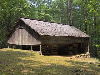
The John Messer Barn is a historic structure within the Great Smoky Mountains National Park in Sevier County, Tennessee, United States. Located along the Porters Creek Trail in the Greenbrier valley, it was constructed in 1875 by Pinkney Whaley. The Whaleys later sold their farm to John H. Messer, who was married to Pinkney's cousin, Lucy. In the 1930s, the Smoky Mountain Hiking Club, which constructed the Smoky Mountain Hiking Club Cabin nearby, leased the barn from the National Park Service. The barn was added to the National Register of Historic Places in 1976, and is the last surviving structure from the pre-park Greenbrier Cove community. This barn should not be confused with the Messer Barn in Cataloochee, which was built by John's cousin, Will Messer.

Rose Glen (Sevierville, Tennessee) human settlement in United States of America

Rose Glen was an antebellum plantation in Sevier County, in the U.S. state of Tennessee. At its height, Rose Glen was one of the largest and most lucrative farms in Sevier County, and one of the most productive in East Tennessee. While the farm is no longer operational, the plantation house and several outbuildings— including a physician's office, loom house, and double-cantilever barn— have survived intact, and have been placed on the National Register of Historic Places.

Maden Hall Farm

Maden Hall Farm, also called the Fermanagh-Ross Farm, is a historic farm near the U.S. city of Greeneville, Tennessee. Established in the 1820s, the farmstead consists of a farmhouse and six outbuildings situated on the remaining 17 acres (6.9 ha) of what was once a 300-acre (120 ha) antebellum farm. Maden Hall has been designated a century farm and has been placed on the National Register of Historic Places.

McCauley and Meyer Barns

The McCauley and Meyer Barns in Yosemite National Park are the last barns in the park that retain their original characteristics as structures built by homesteaders. The McCauley barn and the two Meyer barns represent different construction techniques and styles of design.

Potter–Allison Farm

Potter–Allison Farm is a historic farm complex and national historic district located at Potter Township, Centre County, Pennsylvania. The district includes nine contributing buildings and one contributing site in Centre Hall. The district includes the Potter–Allison House, 19th century wood barn, and a variety of outbuildings including a hog barn, equipment buildings, corn crib, stone slaughterhouse, and a springhouse. Also on the property are the remains of milling and tanning operations. The Georgian-style house was built about 1817, with a Victorian addition dating to the 1850s. It is a 2 1/2-story brick dwelling. The property was originally owned and developed by General James Potter (1729–1789), who built a log cabin and grist mill. The property was acquired by the locally prominent Allison family in 1849.

William Dillard Homestead

The William Dillard Homestead is a historic homestead property in rural northeastern Stone County, Arkansas. It is located on the Round Bottom area northeast of Mountain View, on a plateau above the river's flood plain. It consists of two log structures, both now used as barns, that were built c. 1837, and are the oldest standing structures in the county. A single-pen log cabin stands on rough stone piers, and is covered by a gable roof. The walls are rough-hewn logs, joined by V notches. A shed-roof ell extends on the southern side of the structure, and more modern box-constructed sheds are attached to the north and east sides. A double crib barn stands across the road from the cabin.

David Hanaford Farmstead

The David Hanaford Farmstead is a historic farm in Monticello Township, Minnesota, United States. It was first settled in 1855 and features a farmhouse built in 1870 and a barn from around the same time. The farmstead was listed on the National Register of Historic Places in 1979 for having local significance in the themes of agriculture and exploration/settlement. It was nominated for being "an excellent example of an early Wright County farmstead developed by a pioneer family from New England."

West View Farm human settlement in United States of America

The West View Farm is a historic farm property on Hastings Road in Waterford, Vermont. The farm is unique for its distinctive round barn, built in 1903 to a design by St. Johnsbury architect Lambert Packard, and surviving 19th-century corn crib and smokehouse. The property was listed on the National Register of Historic Places in 1995.

References

  1. 1 2 3 4 5 6 7 8 9 Paul Gordon, National Registration of Historic Places Nomination Form for Tyson McCarter Place, 30 May 1973. Retrieved: 2009-09-15.
  2. 1 2 3 4 5 Michal Strutin, History Hikes of the Smokies (Gatlinburg: Great Smoky Mountains Association, 2003), pp. 274-276.
  3. Carson Brewer, Great Smoky Mountains National Park (Portland, Ore.: Graphic Arts Center Publishing, 1993), p. 21.