National Register of Historic Places listings in Great Smoky Mountains National Park

Last updated

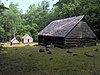
This is a list of the National Register of Historic Places listings in Great Smoky Mountains National Park.

Contents

This is intended to be a complete list of the properties and districts on the National Register of Historic Places in Great Smoky Mountains National Park, North Carolina and Tennessee, United States. The locations of National Register properties and districts for which the latitude and longitude coordinates are included below, may be seen in a map. [1]

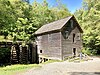
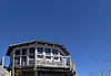
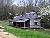
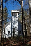
There are 19 properties and districts listed on the National Register in the park.


    This National Park Service list is complete through NPS recent listings posted December 16, 2022. [2]

Map all coordinates using: OpenStreetMap  
Download coordinates as: KML

Current listings

[3] Name on the RegisterImageDate listed [4] Location City or townDescription
1 Mayna Treanor Avent Studio
Mayna Treanor Avent Studio Aventcabinfull2b.jpg
Mayna Treanor Avent Studio
February 7, 1994
(#93001575)
Jake's Creek Trail, 1.0 mile south of Elkton
35°38′21″N83°35′15″W / 35.639167°N 83.5875°W / 35.639167; -83.5875 (Mayna Treanor Avent Studio)
Elkmont
2 Cades Cove Historic District
Cades Cove Historic District Johnolivercabin2.jpg
Cades Cove Historic District
July 13, 1977
(#77000111)
10 miles southwest of Townsend in Great Smoky Mountains National Park
35°35′13″N83°48′54″W / 35.586944°N 83.815°W / 35.586944; -83.815 (Cades Cove Historic District)
Townsend
3 Clingmans Dome Observation Tower
Clingmans Dome Observation Tower Clingman's Dome Tower on a Sunny, Snowy Day.JPG
Clingmans Dome Observation Tower
August 15, 2012
(#12000515)
Terminus of Clingmans Dome Rd.
35°33′46″N83°29′55″W / 35.562766°N 83.498493°W / 35.562766; -83.498493 (Clingmans Dome Observation Tower)
Bryson City
4 Alex Cole Cabin
Alex Cole Cabin Alexcolecabin4.jpg
Alex Cole Cabin
January 2, 1976
(#76000165)
5 miles south of Gatlinburg off U.S. Route 441 in Great Smoky Mountains National Park
35°39′59″N83°31′22″W / 35.666389°N 83.522778°W / 35.666389; -83.522778 (Alex Cole Cabin)
Gatlinburg
5 Elkmont Historic District, Great Smoky Mountains NP
Elkmont Historic District, Great Smoky Mountains NP Ac-cottage-elkmont-tennessee.jpg
Elkmont Historic District, Great Smoky Mountains NP
March 22, 1994
(#94000166)
Off State Route 72 southwest of Gatlinburg
35°39′20″N83°35′04″W / 35.655556°N 83.584444°W / 35.655556; -83.584444 (Elkmont Historic District, Great Smoky Mountains NP)
Gatlinburg
6 Hall Cabin
Hall Cabin HallKressCabin.jpg
Hall Cabin
January 30, 1976
(#76000162)
15 mi. NE of Fontana in Great Smoky Mountains National Park
35°31′12″N83°40′46″W / 35.52°N 83.679444°W / 35.52; -83.679444 (Hall Cabin)
Fontana
7 King-Walker Place
King-Walker Place Walker-sisters-cabin1.jpg
King-Walker Place
March 16, 1976
(#76000169)
West of Gatlinburg off State Route 73 in Great Smoky Mountains National Park
35°41′39″N83°37′45″W / 35.694167°N 83.629167°W / 35.694167; -83.629167 (King-Walker Place)
Gatlinburg
8 Little Greenbrier School-Church
Little Greenbrier School-Church Little-greenbrier-school1.jpg
Little Greenbrier School-Church
January 11, 1976
(#76000168)
About 9 miles west of Gatlinburg off State Route 73 in Great Smoky Mountains National Park
35°41′01″N83°38′17″W / 35.683611°N 83.638056°W / 35.683611; -83.638056 (Little Greenbrier School-Church)
Gatlinburg
9 Look Rock Observation Tower
Look Rock Observation Tower Look Rock Observation Tower.jpg
Look Rock Observation Tower
October 12, 2017
(#100001750)
Foothills Pkwy. W.
35°37′57″N83°56′35″W / 35.632549°N 83.942939°W / 35.632549; -83.942939 (Look Rock Observation Tower)
Walland vicinity
10 Tyson McCarter Place
Tyson McCarter Place McCarter-place-tn1.jpg
Tyson McCarter Place
March 16, 1976
(#76000204)
10 miles east of Gatlinburg on State Route 73 in Great Smoky Mountains National Park
35°46′N83°18′W / 35.76°N 83.3°W / 35.76; -83.3 (Tyson McCarter Place)
Gatlinburg
11 Messer Barn
Messer Barn Messer-barn-great-smokies1.jpg
Messer Barn
January 1, 1976
(#76000166)
Southeast of Gatlinburg near Greenbrier Cove in Great Smoky Mountains National Park
35°41′13″N83°23′54″W / 35.686944°N 83.398333°W / 35.686944; -83.398333 (Messer Barn)
Gatlinburg
12 Mingus Mill
Mingus Mill Mingus Mill, Cherokee, NC.jpg
Mingus Mill
November 29, 2016
(#16000808)
Newfound Gap Rd., Great Smoky Mountains National Park
35°31′12″N83°18′35″W / 35.520065°N 83.309835°W / 35.520065; -83.309835 (Mingus Mill)
Cherokee
13 Mount Cammerer Fire Lookout
Mount Cammerer Fire Lookout Mount-cammerer-lookout1.jpg
Mount Cammerer Fire Lookout
June 12, 2019
(#100004091)
Great Smoky Mountains National Park (GRSM) - end of Mount Cammerer
35°45′49″N83°09′41″W / 35.7635°N 83.1614°W / 35.7635; -83.1614 (Mount Cammerer Fire Lookout)
Cosby
14 Bud Ogle Farm
Bud Ogle Farm Noahoglecabin.jpg
Bud Ogle Farm
November 23, 1977
(#77000158)
3 miles southeast of Gatlinburg
35°40′50″N83°29′28″W / 35.680556°N 83.491111°W / 35.680556; -83.491111 (Bud Ogle Farm)
Gatlinburg
15 Oconaluftee Archeological District February 19, 1982
(#82001715)
Address Restricted
Cherokee
16 Oconaluftee Baptist Church
Oconaluftee Baptist Church Smokemont Baptist Church.jpg
Oconaluftee Baptist Church
January 1, 1976
(#76000163)
6 mi. N of Cherokee on U.S. 441 in Great Smoky Mountains National Park
35°33′13″N83°18′31″W / 35.553611°N 83.308611°W / 35.553611; -83.308611 (Oconaluftee Baptist Church)
Cherokee
17 Oconaluftee Ranger Station
Oconaluftee Ranger Station Oconaluftee Ranger Station (Oconaluftee Administration Building), Cherokee, NC.jpg
Oconaluftee Ranger Station
November 29, 2016
(#16000809)
Newfound Gap Rd., Great Smoky Mountains National Park
35°30′47″N83°18′23″W / 35.513088°N 83.306409°W / 35.513088; -83.306409 (Oconaluftee Ranger Station)
Cherokee
18 John Ownby Cabin
John Ownby Cabin Johnownbycabin5.jpg
John Ownby Cabin
January 1, 1976
(#76000167)
3 miles south of Gatlinburg off State Route 73 in Great Smoky Mountains National Park
35°41′22″N83°32′50″W / 35.689444°N 83.547222°W / 35.689444; -83.547222 (John Ownby Cabin)
Gatlinburg
19 Roaring Fork Historic District
Roaring Fork Historic District Jimbalesplace1.jpg
Roaring Fork Historic District
March 16, 1976
(#76000170)
5 miles southeast of Gatlinburg off State Route 73 in Great Smoky Mountains National Park
35°41′54″N83°28′04″W / 35.698333°N 83.467778°W / 35.698333; -83.467778 (Roaring Fork Historic District)
Gatlinburg

See also

Related Research Articles

<span class="mw-page-title-main">National Register of Historic Places listings in Catawba County, North Carolina</span>

This list includes properties and districts listed on the National Register of Historic Places in Catawba County, North Carolina. Click the "Map of all coordinates" link to the right to view an online map of all properties and districts with latitude and longitude coordinates in the table below.

<span class="mw-page-title-main">National Register of Historic Places listings in Granville County, North Carolina</span>

This list includes properties and districts listed on the National Register of Historic Places in Granville County, North Carolina. Click the "Map of all coordinates" link to the right to view a Google map of all properties and districts with latitude and longitude coordinates in the table below.

<span class="mw-page-title-main">National Register of Historic Places listings in Orange County, North Carolina</span>

This list includes properties and districts listed on the National Register of Historic Places in Orange County, North Carolina. Click the "Map of all coordinates" link to the right to view an online map of all properties and districts with latitude and longitude coordinates in the table below.

<span class="mw-page-title-main">National Register of Historic Places listings in Halifax County, North Carolina</span>

This list includes properties and districts listed on the National Register of Historic Places in Halifax County, North Carolina. Click the "Map of all coordinates" link to the right to view an online map of all properties and districts with latitude and longitude coordinates in the table below.

<span class="mw-page-title-main">National Register of Historic Places listings in Burke County, North Carolina</span>

This list includes properties and districts listed on the National Register of Historic Places in Burke County, North Carolina. Click the "Map of all coordinates" link to the right to view an online map of all properties and districts with latitude and longitude coordinates in the table below.

<span class="mw-page-title-main">National Register of Historic Places listings in Johnston County, North Carolina</span>

This list includes properties and districts listed on the National Register of Historic Places in Johnston County, North Carolina. Click the "Map of all coordinates" link to the right to view Google Maps of all properties and districts with latitude and longitude coordinates in the table below.

<span class="mw-page-title-main">National Register of Historic Places listings in Henderson County, North Carolina</span>

This list includes properties and districts listed on the National Register of Historic Places in Henderson County, North Carolina. Click the "Map of all coordinates" link to the right to view an online map of all properties and districts with latitude and longitude coordinates in the table below.

<span class="mw-page-title-main">National Register of Historic Places listings in Warren County, North Carolina</span>

This list includes properties and districts listed on the National Register of Historic Places in Warren County, North Carolina. Click the "Map of all coordinates" link to the right to view a Google map of all properties and districts with latitude and longitude coordinates in the table below.

<span class="mw-page-title-main">National Register of Historic Places listings in Rutherford County, North Carolina</span>

This list includes properties and districts listed on the National Register of Historic Places in Rutherford County, North Carolina. Click the "Map of all coordinates" link to the right to view a Google map of all properties and districts with latitude and longitude coordinates in the table below.

<span class="mw-page-title-main">National Register of Historic Places listings in Nash County, North Carolina</span>

This list includes properties and districts listed on the National Register of Historic Places in Nash County, North Carolina. Click the "Map of all coordinates" link to the right to view an online map of all properties and districts with latitude and longitude coordinates in the table below.

<span class="mw-page-title-main">National Register of Historic Places listings in Martin County, North Carolina</span>

This list includes properties and districts listed on the National Register of Historic Places in Martin County, North Carolina. Click the "Map of all coordinates" link to the right to view an online map of all properties and districts with latitude and longitude coordinates in the table below.

<span class="mw-page-title-main">National Register of Historic Places listings in Bertie County, North Carolina</span>

This list includes properties and districts listed on the National Register of Historic Places in Bertie County, North Carolina. Click the "Map of all coordinates" link to the right to view an online map of all properties and districts with latitude and longitude coordinates in the table below.

<span class="mw-page-title-main">National Register of Historic Places listings in Vance County, North Carolina</span>

This list includes properties and districts listed on the National Register of Historic Places in Vance County, North Carolina. Click the "Map of all coordinates" link to the right to view an online map of all properties and districts with latitude and longitude coordinates in the table below.

<span class="mw-page-title-main">National Register of Historic Places listings in Cleveland County, North Carolina</span>

This list includes properties and districts listed on the National Register of Historic Places in Cleveland County, North Carolina. Click the "Map of all coordinates" link to the right to view an online map of all properties and districts with latitude and longitude coordinates in the table below.

<span class="mw-page-title-main">National Register of Historic Places listings in Richmond County, North Carolina</span>

This list includes properties and districts listed on the National Register of Historic Places in Richmond County, North Carolina. Click the "Map of all coordinates" link to the right to view a Google map of all properties and districts with latitude and longitude coordinates in the table below.

<span class="mw-page-title-main">National Register of Historic Places listings in Lee County, North Carolina</span>

This list includes properties and districts listed on the National Register of Historic Places in Lee County, North Carolina. Click the "Map of all coordinates" link to the right to view an online map of all properties and districts with latitude and longitude coordinates in the table below.

<span class="mw-page-title-main">National Register of Historic Places listings in Carteret County, North Carolina</span>

This list includes properties and districts listed on the National Register of Historic Places in Carteret County, North Carolina. Click the "Map of all coordinates" link to the right to view an online map of all properties and districts with latitude and longitude coordinates in the table below.

<span class="mw-page-title-main">National Register of Historic Places listings in Person County, North Carolina</span>

This list includes properties and districts listed on the National Register of Historic Places in Person County, North Carolina. Click the "Map of all coordinates" link to the right to view a Google map of all properties and districts with latitude and longitude coordinates in the table below.

<span class="mw-page-title-main">National Register of Historic Places listings in Tyrrell County, North Carolina</span>

This list includes properties and districts listed on the National Register of Historic Places in Tyrrell County, North Carolina. Click the "Map of all coordinates" link to the right to view a Google map of all properties and districts with latitude and longitude coordinates in the table below.

<span class="mw-page-title-main">National Register of Historic Places listings in Gates County, North Carolina</span>

This list includes properties and districts listed on the National Register of Historic Places in Gates County, North Carolina. Click the "Map of all coordinates" link to the right to view a Google map of all properties and districts with latitude and longitude coordinates in the table below.

References

  1. The latitude and longitude information provided in this table was derived originally from the National Register Information System, which has been found to be fairly accurate for about 99% of listings. Some locations in this table may have been corrected to current GPS standards.
  2. National Park Service, United States Department of the Interior, "National Register of Historic Places: Weekly List Actions", retrieved December 16, 2022.
  3. Numbers represent an alphabetical ordering by significant words. Various colorings, defined here, differentiate National Historic Landmarks and historic districts from other NRHP buildings, structures, sites or objects.
  4. The eight-digit number below each date is the number assigned to each location in the National Register Information System database, which can be viewed by clicking the number.