
KwaZulu-Natal is a province of South Africa that was created in 1994 when the Zulu bantustan of KwaZulu and Natal Province were merged. It is located in the southeast of the country, with a long shoreline on the Indian Ocean and sharing borders with three other provinces and the countries of Mozambique, Eswatini and Lesotho. Its capital is Pietermaritzburg, and its largest city is Durban. It is the second-most populous province in South Africa, with slightly fewer residents than Gauteng.

The Drakensberg is the eastern portion of the Great Escarpment, which encloses the central Southern African plateau. The Great Escarpment reaches its greatest elevation – 2,000 to 3,482 metres within the border region of South Africa and Lesotho.

The Maloti-Drakensberg Park is a World Heritage Site, established on 11 June 2001 by linking the Sehlabathebe National Park in the Kingdom of Lesotho and the uKhahlamba Drakensberg Park in KwaZulu-Natal, South Africa. The highest peak is Thaba Ntlenyana rising to 3,482 metres.

Ezemvelo KZN Wildlife is a governmental organisation responsible for maintaining wildlife conservation areas and biodiversity in KwaZulu-Natal Province, South Africa. Their headquarters is in Queen Elizabeth Park situated on the northern slopes of Pietermaritzburg, the KwaZulu-Natal provincial capital. Prior to 1994, it was known as the Natal Parks Board.

Himeville is a small village/town situated in the foothills of the picturesque Southern Drakensberg, KwaZulu-Natal, South Africa, approx 130 km from Pietermaritzburg. It is a landmark en route to the world-famous Sani Pass and the uKhahlamba Drakensberg Park. Himeville is the closest town to the Sani Pass which links the town with Mokhotlong in Lesotho.

The Highveld is the portion of the South African inland plateau which has an altitude above roughly 1500 m, but below 2100 m, thus excluding the Lesotho mountain regions to the south-east of the Highveld. It is home to some of the country's most important commercial farming areas, as well as its largest concentration of metropolitan centres, especially the Gauteng conurbation, which accommodates one-third of South Africa's population.

The Umgeni River or Mgeni River is a river in KwaZulu-Natal, South Africa. It rises in the "Dargle" in the KZN Midlands, and its mouth is at Durban, some distance north of Durban's natural harbour. It is generally agreed its name means "the river of entrance" in Zulu, though other meanings have been suggested.

De Hoop Nature Reserve is a nature reserve in the Western Cape Province of South Africa.
The Kafue Flats are a vast area of swamp, open lagoon and seasonally inundated flood-plain on the Kafue River in the Southern, Central and Lusaka provinces of Zambia. They are a shallow flood plain 240 km (150 mi) long and about 50 km (31 mi) wide, flooded to a depth of less than a meter in the rainy season, and drying out to a clayey black soil in the dry season.

Tràm Chim National Park is a national park in the Plain of Reeds in the Mekong Delta region of Vietnam. The park was created to restore a degraded wetland, in order to protect several rare birds, especially the sarus crane --a species listed on the IUCN Red List. It is also a designated wetland of international importance under the Ramsar Convention.

The uKhahlamba-Drakensberg Park is a protected area in the KwaZulu-Natal province of South Africa, covering 2,428.13 km2 (938 sq mi), and is part of the Maloti-Drakensberg Park, a World Heritage Site. The park includes Royal Natal National Park, a provincial park, and covers part of the Drakensberg, an escarpment formation with the highest elevations in southern Africa.

Mkhambathi Nature Reserve is a protected area at Lusikisiki in the Eastern Cape, South Africa. It is 7,720 hectares, with the Pondoland Marine Protected Area off its coastal edge. The reserve is located in the Pondoland Centre of Plant Endemism and the greater Maputaland–Pondoland–Albany Hotspot, and is covered in open grassland, dotted with patches of indigenous forest, swamp forests and flanked by the forested ravines of the Msikaba and Mtentu rivers.
Blyde River Canyon Nature Reserve is situated in the Drakensberg escarpment region of eastern Mpumalanga, South Africa. The reserve protects the Blyde River Canyon, including sections of the Ohrigstad and Blyde Rivers and the geological formations around Bourke's Luck Potholes, where the Treur River tumbles into the Blyde below. Southwards of the canyon, the reserve follows the escarpment, to include the Devil's and God's Window, the latter a popular viewpoint to the lowveld at the reserve's southern extremity.
Verloren Valei Nature Reserve is a protected area in Mpumalanga, South Africa. One of the few places in the country to breed the three species cranes present in South Africa, the Verloren Vallei Nature Reserve lies roughly 13 km (8.1 mi) outside Dullstroom, a beautiful, peaceful part of the Steenkampsberg plateau that includes rolling grasslands and sensitive wetlands.
Seekoeivlei Nature Reserve is an expansive wetland spanning some 30 km2 near the town of Memel in the Free State, South Africa. The area was declared a Ramsar site in 1999. It is unique for housing more than 250 species of birds, and the town of Memel is now a popular destination for bird enthusiasts, featuring bird hides and picnic facilities. It is also home to some hippopotamus, "seekoei" being the Afrikaans translation, as well as zebra. It lies nearly 2000 m above sea level near the Drakensberg escarpment and close to where the Free State, Mpumalanga, and KwaZulu-Natal meet.
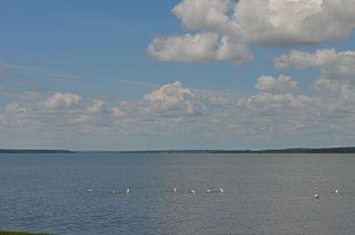
False Bay Park, a Ramsar site wetland since 2015, is a nature reserve that protects the western shores of the freshwater bay, False Bay, and is situated near the coast of northern KwaZulu-Natal, South Africa. False Bay is connected to Lake St. Lucia and both are included in the iSimangaliso Wetland Park.. It covers 1,500 hectares and is located at 34° 4′ S, 18° 30′ E.

The Jagdishpur Reservoir is a reservoir in Jahadi Village Development Committee, Kapilvastu District, Nepal which was named after Er. Jagadish Jha who designed and supervised the construction of Banaganga dam. With a surface area of 225 ha (2.25 km2), it is the largest reservoir in the country and an important wetland site. It is situated at an altitude of 197 m (646 ft). The maximum water depth varies between 2 m (6.6 ft) in the dry season and 7 m (23 ft) in the monsoon season.
Ntsikeni Nature Reserve, in Griqualand East, is the largest wetland and one of the highest above sea level in South Africa.
Lake Letsie is a reservoir in the Drakensberg mountains in Quthing District, Lesotho. The reservoir was formed when a smaller, natural lake was enlarged by damming the source of the Mohlakeng River in 1968. The lake and the wetlands surrounding the shore have been designated as a national protected area since 2001 and a Ramsar site since 2004.

