Ughill

Last updated

Ughill Manor Ughill Manor.jpg
Ughill Manor

Ughill is a small, rural hamlet within the City of Sheffield in Bradfield Parish in England. It is 5 mi (8 km) west-northwest of the city centre. It stands in a lofty position at 918 ft (280 m) above sea level, on a ridge between Bradfield Dale and the valley of the Ughill Brook. It has traditionally been a farming community, but there was some mining in the area in the late 19th and 20th century. Ughill Hall was the scene of an infamous murder in September 1986. The hamlet falls within the Stannington ward of the City.

Contents

History

Ughill is thought to have been founded in the 10th century by a group of Norwegian Vikings with the name deriving from the Old Norse language as Uhgil meaning Uha's Valley or Uggagil meaning Uggi's Valley. In the Old Norse language, gil is a steep-sided valley. [1] Ughill was one of six small estates in Hallamshire named in the Domesday Book of 1086, these included the nearby settlements of Holdworth, Worrall and Onesacre. Just prior to the Norman conquest of England Ughill had developed into an Anglo-Saxon farming holding under the control of Healfdene or Aldene who was Lord of approximately 50 settlements, mainly across Yorkshire, Lincolnshire and Suffolk. [2] After the Conquest ownership of Ughill was taken over by Roger de Busli who was given large swathes of land across Nottinghamshire and Yorkshire for his part in the Conquest. In the Domesday Book Ughill had a taxable value of 1.8 geld units with two plough lands and one league of woodland. [3]

Ughill was mentioned in documents in the late 13th century when the Lord of Hallamshire Thomas de Furnival granted local herbage rights to Ellys and all men of Ughill. Around 1290, the first mention of the Ughil family was recorded in the manor when John the son of John de Ughil was mentioned in a deed, Adam de Ughil and Roger de Ughil were mentioned at a later date, so the surname had become hereditary but it did not survive. By the 15th century, the Marriott family had settled in Ughill, they were another Norman family who rose from modest beginnings to become minor gentry throughout Hallamshire. John Marriott took over a farm in the low-lying part of Ughill in 1442 and was succeeded at the farm by several generations of John Marriotts up to the 17th century. Thomas Marriott (1679–1754) became Lord of the Manor in the early part of the 18th century, where he was styled Mr Marrott of Ughill Hall. Marriott was a Dissenter who in 1743 built Underbank Chapel, four km to the east at Stannington. Thomas was succeeded by his brother Benjamin but the male lineage then failed, ending the Marriotts family’s connection with Ughill after 300 years. [4] [5]

Buildings

Ughill Manor

Ughill Manor is a farmhouse which dates from the early 18th century, however buildings have existed on the site from a much earlier date with timbers from the adjoining cruck barn being dated to 1504. Ughill Manor and its barn and cow house are Grade II listed buildings. [6] [7]

Ughill Hall

Ughill Hall is a substantial stone residence which has been much altered over the years, it existed in a form much different from the present day building in the reign of Edward the Confessor (1042–1066). For many years it was the home of the Marriotts[ who? ]. In more recent times the hall was owned by Charles Vickers who used it as a summer shooting lodge and then by Mr. Lomas,[ who? ] the owner of some of the mines in the surrounding area. The adjacent Ughill Hall farm is still a working farm. [8]

Ughill Hall shootings

The Ughill Hall shootings occurred on 21 September 1986 at Ughill Hall in Bradfield near Sheffield. [9] Ian Wood shot and killed his mistress Danielle Ledez and her daughter Stephanie and severely injured Christopher, Ledez's elder child. [10] He went on the run for eight days when he surrendered to authorities in France after threatening to commit suicide by jumping off Amiens Cathedral. [11] Wood was later convicted of double murder, attempted murder and theft. [12]

Upper House

A plaque on the building states that Upper House was the home of the Worrall family from 1540 to 1988 and that the family had lived in Ughill for in excess of 700 years over 25 generations.

Other buildings in Ughill include Platts Farm, Nether House, Manor Farm Cottage and Cherry Tree Cottage.

Mining

The fire brick company Thomas Wragg & Sons owned a Pot Clay mine immediately to the south east of the hamlet. Pot Clay is a very mouldable type of fireclay long used in the past to make crucibles for the local Sheffield steel industry. It is found in beds together with beds of Ganister throughout the area and from about 1860 was in demand to make casting pit (pouring pit) and ladle control refractory bricks for the growing Sheffield steel industry following the introduction of Bessemer converters. In the early 1970s the mine was producing 15,000 tons of clay per year, with the company quoting, “The mine can be worked at the present rate for 100 years”. A refractory brick works stood at the entrance to the mine. However the Ughill mine had drainage problems and although powerful pumps had been installed in the 1950s to pump between 600 and 800 gallons per minute from the mine, the mine closed on 17 November 1977. It had become uneconomic to mine the clay due to water problems and the owners found it more profitable to bring in clay from the Midlands. The site of the mine has been landscaped and returned to agricultural use. [13] J&J Dyson mined fireclay at their open cast quarry at Wheatshire between Ughill and Sugworth. The quarry is closed but can still be seen from the nearby road. Thos. Wragg had small firebrick works at Load Brook (closed 1957) and Brookside (Stopes Road, Stannington, closed 1960) the former previously owned by the Trickett family, the latter by the Drabble family and a major works (Storrs Fire Clay Works) in the nearby Loxley Valley. Wraggs along with its local competitors, J&J Dyson of Griffs Works, Stannington and Thos. Marshall of Storrs Bridge Fire Brick Works, Loxley, mined the Stannington Pot Clay seam and manufactured fireclay-based casting pit holloware refractories for use in steel making worldwide. All three plants closed following a collapse in demand for casting pit refractories of the type made locally mainly because of the introduction of continuous casting of steel worldwide and the general demise of the British steel industry.

Related Research Articles

Hallamshire

Hallamshire is the historical name for an area of South Yorkshire, England, in the current city of Sheffield.

High Bradfield Village in South Yorkshire, England

High Bradfield is a rural village 6.5 miles (10 km) north-west of the centre of Sheffield in South Yorkshire, England and within the city's boundaries. The village lies just within the Peak District National Park, 1.3 miles (2 km) inside the park's north-eastern border, is at an altitude of 260 metres (850 feet) AOD and has extensive views across Bradfield Dale towards Derwent Edge and the Dark Peak.

Low Bradfield

Low Bradfield is a village within the civil parish of Bradfield in South Yorkshire, England. It is situated within the boundary of the city of Sheffield in the upper part of the Loxley Valley, 6¼ miles west-northwest of the city centre and just inside the northeast boundary of the Peak District National Park. Low Bradfield and the surrounding area is noted for its attractive countryside which draws many visitors from the more urban parts of Sheffield. At weekends the village can become quite crowded, especially when there is a match on the village cricket pitch. Low Bradfield which stands in the shadow of Agden Reservoir has a sister village High Bradfield which is located at a higher altitude, ½ mile to the northeast. The two villages are joined by the steep Woodfall Lane.

Handsworth, South Yorkshire Human settlement in England

Handsworth is a suburb of south eastern Sheffield, in South Yorkshire, England. It covers an area of approximately 5 square miles (13 km2), and has a population of approximately 15,000. It has five schools, four churches, a variety of small shops, a large supermarket, and a range of commercial and light industrial businesses. The area is signposted from M1 Junction 31.

Worrall Village in South Yorkshire, England

Worrall is a small rural village in the civil parish of Bradfield within the boundary of the City of Sheffield. It stands in an elevated position at a height of approximately 230 metres and is 4 miles (6.5 km) north west of Sheffield City Centre. The village has an area of 233 hectares and a population of 1,306 in 2006. At the time of the 2011 Census this village fell within the Stannington ward of the City. Gives details of population and area of village. Although a distinct village, Worrall has tenuous borders with the Sheffield suburbs of Wadsley, Middlewood and Loxley to the south and east and with the adjoining village of Oughtibridge to the north; to the west is a rural area extending out towards the village of High Bradfield.

Totley Suburb of Sheffield in South Yorkshire, England

Totley is a suburb on the extreme southwest of the City of Sheffield, in South Yorkshire, England. Lying in the historic county boundaries of Derbyshire, Totley was amalgamated into the city of Sheffield in 1933, and is today part of the Dore and Totley electoral ward in the city, though it remains close to the contemporary county boundary of Derbyshire. Totley had a population of 7,963 in 2011. Totley was shown at the 2011 census as being part of the ward of Dore and Totley.

Wadsley Human settlement in England

Wadsley is a suburb of the City of Sheffield in South Yorkshire, England. It stands 3 miles (5 km) north-west of the city centre at an approximate grid reference of SK321905. At the 2011 Census the suburb fell within the Hillsborough ward of the City. Wadsley was formerly a rural village which was engulfed by the expansion of Sheffield in the early part of the 20th century.

Loxley, South Yorkshire Human settlement in England

Loxley is a village and a suburb of the city of Sheffield, England. It is a long linear community which stretches by the side of the River Loxley and along the B6077 for almost 2.5 miles (4 km). Loxley extends from its borders with the suburbs of Malin Bridge and Wisewood westward to the hamlet of Stacey Bank near Damflask Reservoir. The centre of the suburb is situated at the junction of Rodney Hill and Loxley Road where the old village green stands and this is located 3 miles (5 km) north west of Sheffield city centre. The suburb falls within the Stannington ward of the City of Sheffield.

Areas of Sheffield

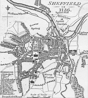
The areas of Sheffield, a city and metropolitan borough in the north of England, vary widely in size and history. Some of the areas developed from villages or hamlets, that were absorbed into Sheffield as the city grew, and thus their centres are well defined, but the boundaries of many areas are ambiguous. The areas of Sheffield do not play a significant administrative role, but the city is divided into 28 electoral wards for local elections and 6 parliamentary constituencies for national elections.

Oughtibridge Village in South Yorkshire, England

Oughtibridge is a residential village on the northern outskirts of Sheffield within the bounds of Bradfield civil parish. The village stands 5 miles (8 km) northwest of the city centre in the valley of the River Don. The population of the village has increased significantly in recent years due to much private housing development and stood at 3,542 in 2006 over an area of 355 hectares. The population of Oughtibridge increased to 3,584 in 2011.

History of Sheffield History of the English town

The area known as Sheffield was probably founded in the second half of 1AD in a clearing by the River Sheaf although humans may have lived in the area for at least 10,000 years.

Shirland Human settlement in England

Shirland is a former pit village in Derbyshire, England. Together with the neighbouring villages of Higham, Stretton and Stonebroom, it forms part of the civil parish of Shirland and Higham, which had a population of 4,802 at the 2011 Census. The River Amber flows through the parish.

Dungworth Hamlet in South Yorkshire, England

Dungworth is a hamlet in the civil parish of Bradfield, west of Sheffield in South Yorkshire, England.

Onesacre Hall

Onesacre Hall is a Grade II* Listed building situated in the rural outskirts of the City of Sheffield in South Yorkshire, England. The hall is located on Green Lane in the small hamlet of Onesacre in the suburb of Oughtibridge, 5 miles (8.5 km) north west of the city centre.

Glenboig

Glenboig is a village in North Lanarkshire, Scotland lying north of Coatbridge and to the south east of Kirkintilloch and is approximately 10 miles from Glasgow City Centre. According to a 2012 estimate, the population of Glenboig was 2780.

Stannington, Sheffield Suburb of Sheffield in South Yorkshire, England

Stannington is a suburb in the City of Sheffield, England. The area is located in the civil parish of Bradfield, and is in the electoral ward of Stannington. Stannington is situated right on the western edge of the Sheffield urban area

Holdworth

Holdworth is a small rural hamlet situated within the boundary of the City of Sheffield, England. It is located 4.7 miles (7.5 km) northwest of the city centre at an altitude of 280 metres above sea level, giving it extensive views south over the upper Loxley valley. The hamlet falls within the Stannington ward of the City. It is an ancient farming settlement which was mentioned in the Domesday Book of 1086.

Storrs, South Yorkshire Human settlement in England

Storrs is a hamlet within the boundaries of the City of Sheffield in England, it is situated 6.5 km west-northwest of the city centre. Storrs is located between the suburb of Stannington and the village of Dungworth in the civil parish of Bradfield at a height of 210 metres above sea level between the Loxley and Rivelin valleys. Although historically a farming settlement, water-powered milling on the Storrs Brook and small scale cutlery making has also taken place in the hamlet.

Brightholmlee

Brightholmlee is a small rural hamlet situated within the City of Sheffield in England. The hamlet falls within the Stannington Ward of the City. It is located 6.2 miles (10 km) north-west of the city centre and 0.6 miles (1 km) west of Wharncliffe Side within Bradfield Parish. Previously a farming community, it consist of four farmsteads, Manor Farm, Old Hall Farm, High Lea Farm and Lee Farm. It is now almost entirely residential with the last working farm being sold for development in 2013.

Bradfield Dale

Bradfield Dale is a rural valley 12 kilometres (7.5 mi) west-northwest of the City of Sheffield in England. The valley stands within the north-eastern boundary of the Peak District National Park just west of the village of Low Bradfield. The dale is drained by the Strines Dike which becomes the Dale Dike lower down the valley, these being the headwaters of the River Loxley. The dale contains two reservoirs, Strines and Dale Dike, and a third Agden Reservoir stands in a side valley just above Low Bradfield. The dale is characterised by agricultural land interspersed with farming and residential buildings. It is approximately 5 kilometres (3.1 mi) long from its foot at Low Bradfield to its head on Strines Moor.

References

  1. Worrall family from Ughill Archived 5 February 2015 at the Wayback Machine Gives details of name meaning.
  2. Open Domesday Gives details of Healfdene‘s settlements.
  3. Open Domesday Archived 5 February 2015 at the Wayback Machine Gives details of Ughill in Domesday Book.
  4. Rotherhamweb Archived 5 February 2015 at the Wayback Machine The Marriotts of Ughill.
  5. "Historic Hallamshire", David Hey, Landmark Collectors Library, ISBN   1 84306 049 3, Gives general history of Ughill.
  6. Historic England. "Ughill Manor (1132822)". National Heritage List for England . Retrieved 5 February 2015.
  7. Historic England. "Ughill Manor Cruck Barn (1192583)". National Heritage List for England . Retrieved 5 February 2015.
  8. Local Mouth Archived 5 February 2015 at the Wayback Machine Gives details of Ughill Hall.
  9. "Ian Wood alleged to have shot his mistress and her children". The Guardian. 24 September 1986.
  10. "Solicitor 'agreed suicide pact'". The Independent. 22 July 1987.
  11. Odell, Robin; Donnelley, Paul (4 February 2016). The Mammoth Book of More Bizarre Crimes. Hachette UK. pp. 212–213. ISBN   9781472118042.
  12. "Solicitor gets life as jury rejects suicide pact claim". The Independent. 31 July 1987.
  13. "The Forgotten Mines of Sheffield", Ray Battye, ALD Design & Print, ISBN   1 901 587 40 1, pages 70, Gives details of mining.

Coordinates: 53°24′37″N1°36′42″W / 53.410242°N 1.611782°W / 53.410242; -1.611782