
Custer County is a county located in the U.S. state of Oklahoma. As of the 2020 census, the population was 28,513. Its county seat is Arapaho. The county was named in honor of General George Armstrong Custer.

Custer County is a county located in the U.S. state of Colorado. As of the 2020 census, the population was 4,704. The county seat is Westcliffe.

The Town of Erie is a Home Rule Town located in Weld and Boulder counties, Colorado, United States. The town population was 30,038 at the 2020 United States Census, a +65.64% increase since the 2010 United States Census. At the 2020 census, 17,387 (58%) Erie residents lived in Weld County and 12,651 (42%) lived in Boulder County. Erie is a part of the Denver-Aurora, CO Combined Statistical Area and the Front Range Urban Corridor.
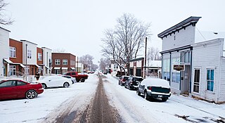
The City of Lafayette is a home rule municipality located in southeastern Boulder County, Colorado, United States. The city population was 30,411 at the 2020 United States Census.

Franktown is an unincorporated town, a post office, and a census-designated place (CDP) located in and governed by Douglas County, Colorado, United States. The CDP is a part of the Denver–Aurora–Lakewood, CO Metropolitan Statistical Area. The Franktown post office has the ZIP Code 80116. At the United States Census 2020, the population of the Franktown CDP was 409.

Parker is a home rule municipality in Douglas County, Colorado, United States. As a self-declared "town" under the home rule statutes, Parker is the second most populous town in the county; Castle Rock is the most populous. In recent years, Parker has become a commuter town at the southeasternmost corner of the Denver metropolitan area. The population was 58,512 at the 2020 census. Parker is now the 19th most populous municipality in the state of Colorado.

Auraria was a small mining settlement in the Kansas Territory in the United States. Today it survives in its original location as a neighborhood of Denver, Colorado, south of the confluence of Cherry Creek and the South Platte River.

Railroad Wars were business rivalries between railroad companies, which occurred frequently in American history. Although they were usually little more than legal disputes inside a courtroom, they sometimes turned into armed conflicts. There has been competition between railroad companies since the beginning of railroading in the United States, but violent confrontations were most common in the final quarter of the 19th century, particularly in the Old West.
Falcon is an unincorporated community exurb in El Paso County, Colorado, United States. It lies along US 24 about 14 miles northeast of Colorado Springs. A railroad hub in the early 20th century, the town spent several decades as a quiet ranching community until it experienced rapid residential growth throughout the 1990s which has continued increasingly through today. The population of Falcon as of 2009 was estimated to be 10,514. The U.S. Post Office in Peyton, Colorado serves Falcon postal addresses.

Granite is an unincorporated community with a U.S. Post Office in Chaffee County, Colorado, United States. The zip code of Granite is 81228. According to the 2010 census, the population is 116.

Before it was founded, the site of modern-day Colorado Springs, Colorado, was part of the American frontier. Old Colorado City, built in 1859 during the Pike's Peak Gold Rush was the Colorado Territory capital. The town of Colorado Springs was founded by General William Jackson Palmer as a resort town. Old Colorado City was annexed into Colorado Springs. Railroads brought tourists and visitors to the area from other parts of the United States and abroad. The city was noted for junctions for seven railways: Denver and Rio Grande (1870), Denver and New Orleans Manitou Branch (1882), Colorado Midland (1886–1918), Colorado Springs and Interurban, Atchison, Topeka, and Santa Fe (1889), Rock Island (1889), and Colorado Springs and Cripple Creek Railways. It was also known for mining exchanges and brokers for the Cripple Creek Gold Rush.
Rosita was a silver mining town — now a ghost town — in Custer County, Colorado, United States. Rosita is Spanish for little rose. Although the old town has almost entirely disappeared, the surrounding area has been largely developed into semi-rural home sites.
The following is a timeline of the history of the city of Colorado Springs, Colorado, USA.
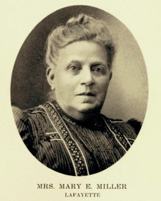
Mary E. Miller (1843–1921) settled in the Territory of Colorado in 1863 with her husband, Lafayette Miller. After her husband died, she founded the town of Lafayette, Colorado, named for her husband. Miller was called the "Mother of Lafayette. She was the first woman bank president in the United States, a philanthropist and an astute businesswoman.

William Henry Perkins, better known as "Moccasin Bill" Perkins, was a frontiersman, scout, and hunter. Born in Indiana, he learned to trap and hunt as a child when the area was a wilderness. He continually moved west to Missouri, Kansas, central Colorado, and ultimately the Western Slope of Colorado. During the American Civil War, he was a government scout out of Fort Scott and was injured by Native American arrows. He tried his hand at farming in Kansas, but yearned for the frontier where he was a hunter, trapper, and miner. He was particularly known for his skill as a bear hunter. He was a friend of Buffalo Bill.
San Juan City was designated the county seat of Hinsdale County, Colorado when the county was established on February 10, 1874. On February 23, 1875, voters decided to move the county seat to Lake City. The town began as a mining camp, with the goal to become a hub for transportation of supplies to area mines. After a year as the county seat, it became a stage stop, offering food and lodging. It operated as a stage stop, post office, and roadhouse into the 1880s. In 1893, San Juan City became part of Mineral County, Colorado. A post office operated out of San Juan City, off and on, until 1923. The town's site, located along Clear Creek, is now Freemon's Guest Ranch. San Juan Ranch is also said to be the former site of San Juan City, but the former Galloway's transportion hub that became San Juan Ranch was located a few miles away from the town.
Wason, Colorado, also spelled Wasson, became the county seat of Mineral County, Colorado, when the state legislature established it on March 27, 1893. Disagreeing with their decision, the Town Council voted Creede as the county seat in November 1893. To solidify the matter, a group of town residents went to Wason in the night. They dismantled the courthouse and took it with the county records to Creede. The Wason town was located on Colorado State Highway 149, 2.3 miles (3.7 km) southeast of Creede and 6 miles (9.7 km) north of Wagon Wheel Gap.

