The history of Moldova can be traced to the 1350s, when the Principality of Moldavia, the medieval precursor of modern Moldova and Romania, was founded. The principality was a vassal of the Ottoman Empire from 1538 until the 19th century. In 1812, following one of several Russian-Turkish wars, the eastern half of the principality, Bessarabia, was annexed by the Russian Empire. In 1918, Bessarabia briefly became independent as the Moldavian Democratic Republic and, following the decision of the Parliament, united with Romania. During the Second World War it was occupied by the Soviet Union which reclaimed it from Romania. It joined the Union as the Moldavian ASSR, until the dissolution of the USSR. In 1991 the country declared independence as the Republic of Moldova.
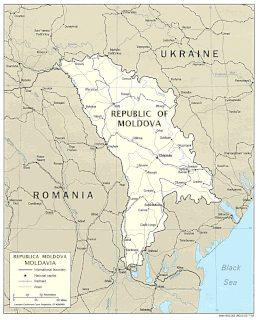
Located in Eastern Europe, Moldova is bordered on the west and southwest by Romania and on the north, south, and east by Ukraine. Most of its territory lies in Bessarabia region, between the area's two main rivers, the Nistru and the Prut. The Nistru forms a small part of Moldova's border with Ukraine in the northeast and southeast, but it mainly flows through the eastern part of the country, separating Bessarabia and Transnistria. The Prut River forms Moldova's entire western boundary with Romania. The Danube touches the Moldovan border at its southernmost tip, and forms the border for 200 metres (656 ft).
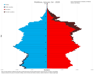
This article is about the demographic features of the population of Moldova, including distribution, ethnicity, languages, religious affiliation and other statistical data.

Bessarabia is a historical region in Eastern Europe, bounded by the Dniester river on the east and the Prut river on the west. About two thirds of Bessarabia lies within modern-day Moldova, with the Ukrainian Budjak region covering the southern coastal region and part of the Ukrainian Chernivtsi Oblast covering a small area in the north.

Bender or Bendery, also known as Tighina, is a city within the internationally recognized borders of Moldova under de facto control of the unrecognized Pridnestrovian Moldavian Republic (Transnistria) (PMR) since 1992. It is located on the western bank of the river Dniester in the Romanian historical region of Bessarabia.
Bălți is a city in Moldova. It is the second largest city in terms of population, area and economic importance, after Chișinău. The city is one of the five Moldovan municipalities. Sometimes also called "the northern capital", it is a major industrial, cultural and commercial centre and transportation hub in the north of the country. It is situated 127 kilometres (79 mi) north of the capital Chișinău, and is located on the river Răut, a tributary of the Dniester, on a hilly landscape in the Bălți steppe.
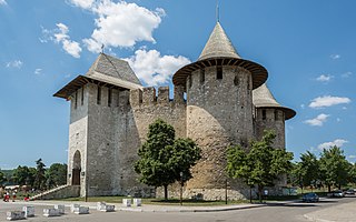
Soroca is a city and municipality in Moldova, situated on the Dniester river about 160 km north of Chișinău. It is the administrative center of the Soroca District.

According to the Moldovan law on territorial administrative organisation, Moldova is divided administratively into the following administrative territorial units: districts, cities/towns and villages. The administrative territorial organization of Moldova is made on 2 levels:
- villages (communes), sectors and cities/towns (municipii) constitute the first level,

Cimișlia is a town located in the southern part of Moldova situated on the banks of the Cogâlnic River, between the capital of Chișinău and the autonomous territorial unit of Gagauzia. Cimişlia had a population of 11,997 according to the 2014 census. The town is also the seat/administrative center of Cimișlia District. It also administers three villages s follows: Bogdanovca Nouă, Bogdanovca Veche, and Dimitrovca.

Briceni is a district in the north-west of Moldova, with the administrative center at Briceni. The other major city is Lipcani. As of January 1, 2011, its population was 75,300.
Mileștii Mici is a commune in Ialoveni District, Moldova, composed of two villages, Mileștii Mici and Piatra Albă. It has a population of over 4,500 and is 18 km from Chişinău. For much of its history, the locals have extracted white stone from underneath the village. Several hundred kilometers of the underground extraction site exist today. Some of the shafts are used as cellars for storing Milestii Mici wines.

Fălești is a district in the north of Moldova, with the administrative center at Fălești. As of January 1, 2011, its population was 92,600.

Rîșcani is a district in the north-west of Moldova, with the administrative center at Rîșcani. The other major city is Costești. As of 1 January 2011, its population was 70,000.

Ștefan Vodă is a district in the south-east of Moldova, with the administrative center at Ștefan Vodă. As of 1 January 2011, its population was 71,900. The district is situated 100 km from Chișinău and 100 km from Odessa, Ukraine.

Ialoveni is a district in the central part of Moldova, with the administrative center at Ialoveni. As of 1 January 2011, its population was 99,100.

Strășeni is an administrative district in the central part of Moldova. Its administrative center and leading city is Strășeni. As of 1 January 2011, its population was 91,100. The other principal town is Bucovăț, 26 km (16 mi) to the north of the Moldovan capital. Otherwise the district is divided between rural communities.

Leova is a city in Moldova, located 92 km southwest of the national capital, Chișinău. It is the administrative center of Leova District. The city is situated on the east bank of the river Prut bordering Romania.

The Dubăsari District is a district in the east of Moldova, with the administrative center at Cocieri. As of January 1, 2011, its population was 35,200. This does not include the 715 people that live in the village of Roghi, which is controlled by the breakaway Tiraspol authorities. Dubăsari means ferry-arks.
Cricova is a Moldovan town, located 15 kilometres (9.3 mi) north of Chișinău, the capital of the country. Cricova is famous for its wine cellars, which make it a popular attraction for tourists.

Currently, there are three types of public roads in the Republic of Moldova:


