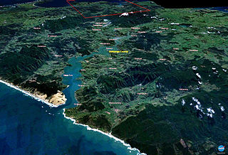
The Hokianga is an area surrounding the Hokianga Harbour, also known as the Hokianga River, a long estuarine drowned valley on the west coast in the north of the North Island of New Zealand.

Rangiahua is a small locality near the Hokianga Harbour in the Northland Region of New Zealand. State Highway 1 passes through it. Umawera is to the west, and Okaihau to the east. Rangiahua is part of the Omahuta Forest-Horeke statistical area, which covers the upper Hokianga Harbour. For demographics of this area, see Horeke.
Wainui is a locality in the Rodney Ward of the Auckland Region of New Zealand. It is 5 kilometres (3.1 mi) north-east of Waitoki and 10 kilometres (6.2 mi) west of Orewa. The Wainui Stream flows south-west through the area and into the Kaukapakapa River.

Horeke is a settlement in the upper reaches of the Hokianga Harbour in Northland, New Zealand. Kohukohu is just across the harbour. The Horeke basalts are located near the town, and can be viewed on an easy stroll through the Wairere Boulders, a commercial park.
Whirinaki is a locality on the Whirinaki River in the south Hokianga, in Northland, New Zealand. The name means "to lean against a support". Highway 12 runs through it. Opononi lies to the south west, and Rawene lies to the north east.

Whangaroa Harbour, previously spelled Wangaroa Harbour, is an inlet on the northern coast of Northland, New Zealand. Whangaroa Bay and the Pacific Ocean are to the north. The small settlements of Totara North and Saies are on the west side of the harbour, Waitaruke on the south side, and Whangaroa on the east. State Highway 10 runs through Waitaruke. The name comes from the lament "Whaingaroa" or "what a long wait" of a woman whose warrior husband had left for a foray to the south. The harbour was formed when rising sea levels drowned a river valley about 6,000 years ago. Steep outcrops remain from ancient volcanic rocks.
Waiharara is a community at the base of the Aupouri Peninsula in Northland, New Zealand. State Highway 1 runs through the community. To the west is Aupouri Forest, and beyond that Ninety Mile Beach. To the east is Rangaunu Harbour. Houhora is 22 km north west, and Awanui is 16 km south east. Lake Waiparera, 35 metres above sea level, is immediately to the north west.

Manaia is a locality on the western side of the Coromandel Peninsula of New Zealand. It lies to the east of State Highway 25, south of Coromandel and north of Tapu. The Manaia River flows from the Coromandel Range through the area and into the Manaia Harbour to the west. The harbour contains mussel farms.
Aranga is a locality in Northland, New Zealand. State Highway 12 passes through it. Ōmāpere is 47 km northwest, and Dargaville is 42 km southeast. The Waipoua Forest is to the north. Maunganui Bluff and the Tasman Sea are to the west, with the small settlement of Aranga Beach lying at the northern end of Ripiro Beach.
Arapohue is a locality in Northland, New Zealand, approximately 16 km south east of Dargaville
Tangowahine is a community on the northern Kaipara Harbour in Northland, New Zealand. The Tangowahine Stream flows from the Tutamoe Range east and then south to join the Wairoa River at Tangowahine. State Highway 14 passes through Tangowahine. Dargaville is 12 km to the south west, and Tangiteroria is 15 km north east.
Karetu is a community in the Northland Region of the North Island of New Zealand. Kawakawa is to the west, and Waikare is northeast. The Karetu River flows from the Russell Forest in the southeast through Karetu, and joins the Kawakawa River shortly before it flows into the Bay of Islands.
Matarau is a locality in Northland, New Zealand. Kamo is to the southeast. The area is changing from farmland to lifestyle blocks.
Purua is a locality north west of Whangārei in Northland, New Zealand. A hill also called Purua with a summit 387 m above sea level lies to the east. The area mainly consists of rolling hills and river flats. Farming is Dairy, Sheep and Beef. The local hall is one of the notable buildings.
Pipiwai is a locality in the Te Horo valley in Northland, New Zealand. Whangārei is about 35 km to the southeast. Titoki is about 16 km to the south.
Fairhall is a locality in Marlborough, New Zealand. Blenheim is about 7.5 km to the northeast. The Fairhall River runs past to the west.
Kakaramea is a town in South Taranaki, New Zealand. State Highway 3 passes through it. Patea is about 6 km to the south-east, and Hāwera is about 20 km to the north-west.
Kaimata is a locality in Taranaki, New Zealand. Inglewood is about 7.5 km to the west. The Manganui River flows past to the west. Kaimata was one of many townships established to service the dairy industry.
Maruia is a locality in the West Coast region of New Zealand. The Shenandoah Highway passes through it. Murchison is 65 km north, the Lewis Pass is 39 km to the south-east, and Reefton is 63 km west by road. The Maruia River flows past to the west.

Marybank is a suburb of Nelson, New Zealand. It lies on State Highway 6 close to the northern end of Nelson Haven, between Atawhai and Wakapuaka.
