Umm Qasr Port

Last updated
Umm Qasr Port
Umm qasr.jpg
Cranes at Umm Qasr await cargo
Umm Qasr Port
Click on the map for a fullscreen view
Location
Country Iraq
Location Umm Qasr, Basra, Iraq
Coordinates 30°03′12″N47°56′15″E / 30.05335°N 47.93756°E / 30.05335; 47.93756
UN/LOCODE IQUQR [1]
Details
Owned by Iraqi Government

Umm Qasr Port is Iraq's only deep water port, part of the city of Umm Qasr.

Contents

Iraq's second biggest port in scale of size and goods shipped, ranking behind the port of Basra, it is strategically important, located on the western edge of the al-Faw peninsula, where the mouth of the Shatt al Arab waterway enters the Persian Gulf. It is separated from the border of Kuwait by a small inlet. Prior to the Persian Gulf War, traffic between Kuwait and Iraq flowed over a bridge. The port is part of the Maritime Silk Road. [2] [3]

History

Umm Qasr was originally a small fishing town, [4] but was said to have been the site of Alexander the Great's landing in Mesopotamia in 325 BC. During the Second World War a temporary port was established there by the Allies to unload supplies to dispatch to the Soviet Union. It fell back into obscurity after the war, but the government of King Faisal II sought to establish a permanent port there in the 1950s. [5]

In 1958 after the coup d'etat of the Iraqi Army known as the 14 July Revolution, the Iraqi Navy established a base there. The new regime of General Abdul-Karim Qassem undertook mass planning of the economy of Iraq, based on oil export and factory based production, which required new shipping facilities. Founded in 1961, it was intended to serve as Iraq's only "deep water" port, reducing the country's dependence on the disputed Shatt al-Arab waterway that marks the border with Iran. The port facilities were built by a consortium of companies from West Germany, Sweden and Lebanon, with Iraqi Republic Railways services connecting it to Basra and Baghdad. [6] The port opened for business in July 1967. [7]

Iran–Iraq War

During the Iran–Iraq War (1980–88), the ports importance increased as fighting restricted access to other ports further east along the Shatt al-Arab. The port of Basra, located on the Shatt al-Arab waterway, became unusable as it was just miles from the Iranian border. [4]

First Gulf War

After the 1991 First Gulf War, during which the port was bombed, control of the inlet leading to Umm Qasr was transferred to Kuwait. Under control of Allied Forces for a period, in defence planning for Kuwait, the bridge was removed and a large trench and sand berm was constructed along the border of the two nations. [4]

Once the port was returned to the Iraqi Government of Saddam Hussein, he shifted most of the commerce from the port of Basra to Umm Qasr, in a deliberate Iraqi government policy to punish Basra for its role in the rebellions against his rule. [4]

Second Gulf War

Polish GROM troops on alert immediately after the ports capture during the Battle of Umm Qasr GROM DN-SD-04-01612.JPEG
Polish GROM troops on alert immediately after the ports capture during the Battle of Umm Qasr

The Battle of Umm Qasr was the first military confrontation in the Iraq War, with its objective the capture of the port.

On March 21, 2003, the battle was started with an amphibious assault by British 3 Commando Brigade of the Royal Marines, and spearheaded on land by the US 15th Marine Expeditionary Unit, supported by Polish GROM troops. Iraqi forces put up unexpectedly strong resistance, requiring several days' fighting before the area was cleared of defenders. [8] After the waterway was de-mined by a Detachment from HM-14 and Naval Special Clearance Team ONE of the U.S. Navy and reopened, Umm Qasr played an important role in the shipment of humanitarian supplies to Iraqi civilians. [9]

The Royal Fleet Auxiliary, Lananding Ship Logistic RFA Sir Galahad arrives in the port on 28 March 2003, delivering the first shipment of humanitarian aid from coalition forces US Navy 030328-N-3783H-279 The Royal Fleet Auxiliary, Landing Ship Logistic RFA Sir Galahad (L 3005) arrives in the Iraqi port city of Umm Qsar.jpg
The Royal Fleet Auxiliary, Lananding Ship Logistic RFA Sir Galahad arrives in the port on 28 March 2003, delivering the first shipment of humanitarian aid from coalition forces

The port was declared safe and open on March 25, 2003, after Royal Marines took over control of the port and conducted raids into the old part of town. Coalition minesweepers, including HMS Bangor (M109), aided by US Navy divers, MH-53E Sea Dragon helicopters towing magnetic minesweeping sleds, unmanned underwater vehicles, EOD divers, plus trained dolphins and seals; located and cleared the approach to the port of underwater mines. On 28 March a 200-yard-wide channel was declared safe, and the Royal Fleet Auxiliary RFA Sir Galahad docked to begin offloading hundreds of tons of food and water. Work continued for six weeks after that, widening the channel.

Reconstruction

New Iraqi Navy patrol boat in Port of Umm Qasr PatrouillenbootIrakP104.jpg
New Iraqi Navy patrol boat in Port of Umm Qasr

On 23 May 2003, control of the facility was transferred from the Spanish Army operating under the Royal Marines, [10] to Stevedoring Service of America (SSA). The company is responsible for both operations as well as restoration and renovation of the facility, which will be turned over to Iraqi civilian control when it is fully operational. [11]

In January 2004 it was announced that work would start on a $10.3 million project to renovate the Umm Qasr Naval Base, funded through the Project Management Office (PMO) of the Coalition Provisional Authority. To enable the Iraqi security forces the facilities they need for the defence of their country, the project includes building renovation; construction of electrical, water and sanitary sewage systems; security improvements; dock repair and dredging. The prime contractor was Weston Solutions, Inc. of West Chester, Pennsylvania, who completed the work in mid-May 2004. [11]

Related Research Articles

<span class="mw-page-title-main">Geography of Iraq</span> Geographic features of Iraq

The geography of Iraq is diverse and falls into five main regions: the desert, Upper Mesopotamia, the northern highlands of Iraq, Lower Mesopotamia, and the alluvial plain extending from around Tikrit to the Persian Gulf.

Transport in Iraq consists of railways, highways, waterways, pipelines, ports and harbors, marines and airports.

<span class="mw-page-title-main">Geography of Kuwait</span>

Kuwait is a country in West Asia, bordering the Persian Gulf, between Iraq and Saudi Arabia. Kuwait is located at the far northwestern corner of the Persian Gulf. Kuwait is 17,820 square kilometres in size. At its most distant points, it is about 200 km (120 mi) north to south, and 170 km (110 mi) east to west. Kuwait has 10 islands. Kuwait's area consists mostly of desert.

<span class="mw-page-title-main">Basra</span> City in Basra Governorate, Iraq

Basra is a city in southern Iraq located on the Shatt al-Arab. It had an estimated population of 1.4 million in 2018. Basra is also Iraq's main port, although it does not have deep water access, which is handled at the port of Umm Qasr. However, there is ongoing construction of Grand Faw Port on the coast of Basra, which is considered a national project for Iraq and will become one of the largest ports in the world and the largest in the Middle East, in addition, the port will strengthen Iraq's geopolitical position in the region and the world. Furthermore, Iraq is planning to establish a large naval base in the Faw peninsula.

<span class="mw-page-title-main">Shatt al-Arab</span> River in Western Asia

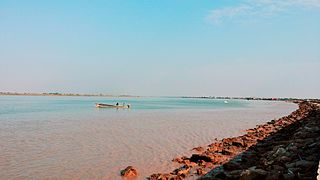
The Shatt al-Arab is a river of some 200 kilometres (120 mi) in length that is formed at the confluence of the Euphrates and Tigris rivers in the town of al-Qurnah in the Basra Governorate of southern Iraq. The southern end of the river constitutes the Iran–Iraq border down to its mouth, where it discharges into the Persian Gulf. The Shatt al-Arab varies in width from about 232 metres (761 ft) at Basra to 800 metres (2,600 ft) at its mouth. It is thought that the waterway formed relatively recently in geological time, with the Tigris and Euphrates originally emptying into the Persian Gulf via a channel further to the west. Kuwait's Bubiyan Island is part of the Shatt al-Arab delta.

<span class="mw-page-title-main">Timeline of the 2003 invasion of Iraq</span>

This is a timeline of the events surrounding the United States-led invasion of Iraq in 2003.

<span class="mw-page-title-main">Umm Qasr</span> Place in Basra, Iraq

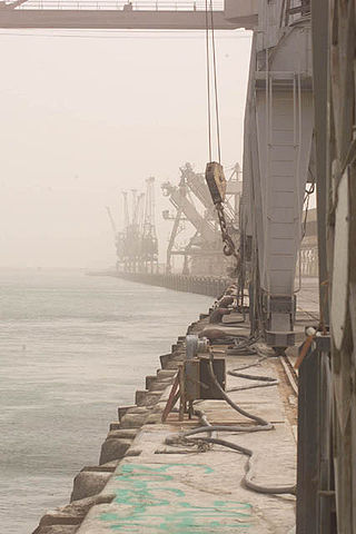
Umm Qasr is a port city in southern Iraq. It stands on the canalised Khawr az-Zubayr, part of the Khawr Abd Allah estuary which leads to the Persian Gulf. It is separated from the border of Kuwait by a small inlet. A bridge across the waterway linked the port with Kuwait prior to the 1991 Persian Gulf War.

<span class="mw-page-title-main">Basra Governorate</span> Governorate of Iraq

Basra Governorate, also called Basra Province, is a governorate in southern Iraq in the region of Arabian Peninsula, bordering Kuwait to the south and Iran to the east. The capital is the city of Basra, located in the Basrah district. Other districts of Basra include Al-Qurna, Al-Zubair, Al-Midaina, Shatt Al-Arab, Abu Al-Khaseeb and Al-Faw located on the Persian Gulf. It is the only governorate with a coastline.

<span class="mw-page-title-main">Al-Faw peninsula</span> Landform in southwest Iraq

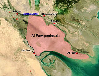
The Al-Faw peninsula is a peninsula in the Persian Gulf, located in the extreme southeast of Iraq. The marshy peninsula is 20 km (12 mi) southeast of Iraq's third largest city, Basra, and is part of a delta for the Shatt al-Arab river, formed by the confluence of the major Euphrates and Tigris rivers. The al-Faw peninsula borders Iran to the northeast, with the cities of Abadan and Khorramshahr on the opposite side of the Shatt al-Arab, and Kuwait to the southwest, opposite from Bubiyan Island and Warbah Island, near the Iraqi city of Umm Qasr.

<span class="mw-page-title-main">Al-Faw</span> Place in Al-Basrah, Iraq

Al-Fāw is a port town on Al-Faw Peninsula in Iraq near the Shatt al-Arab and the Persian Gulf. The Al Faw Peninsula is part of the Basra Governorate.

The Khawr Abd Allah is today an estuary, but once was the point where the Shatt al-Arab emptied into the Persian Gulf. It is located in southern Iraq and northern Kuwait. Both countries' border divides the lower portion of the estuary, but adjacent to the port of Umm Qasr, the estuary becomes wholly Iraqi. The Shatt al-Arab is now the from which the rivers drain out and is east of the Khawr Abd Allah. As the estuary extends northwestward into Iraq, it changes its name to Khawr az-Zubayr at Umm Qasr. From that point, it links by canal again to the northwest and into the Tigris and Euphrates proper. It forms the northeastern coastline of Jazirat Bubiyan and the northern coastline of Jazirat Warbah. Both of these islands are officially Kuwait.

<span class="mw-page-title-main">Iraqi Navy</span> Maritime warfare branch of Iraqs military

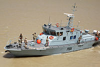
The Iraqi Naval Forces, or the Iraqi Navy, is the naval warfare service branch of the Armed forces of Iraq. Formed in 1937, initially as the Iraqi Coastal Defense Force, its primary responsibilities was the protection of Iraq's coastline and offshore assets, the official name was changed on 12 January 2005 to Iraqi Naval Forces

<span class="mw-page-title-main">Battle of Umm Qasr</span> First military confrontation in the Iraq War

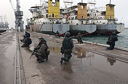
The Battle of Umm Qasr was the first military confrontation in the Iraq War. At the start of the war, one of the first objectives was the port of Umm Qasr. On 21 March 2003, as allied forces advanced across Southern Iraq, an amphibious landing force captured the new port area of Umm Qasr. The assault was spearheaded by Royal Marines of the British 3 Commando Brigade, augmented by U.S. Marines of the American 15th MEU and Polish JW GROM troops. Iraqi forces in the old town of Umm Qasr put up unexpectedly strong resistance, requiring several days' fighting before the area was cleared of defenders. The port was finally declared safe and reopened on 25 March 2003.

<span class="mw-page-title-main">Iran–Iraq border</span> International border

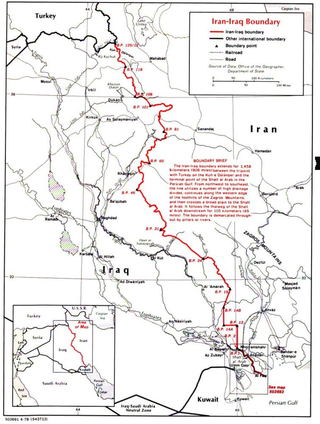
The Iran–Iraq border runs for 1,599 km (994 mi) from the tripoint with Turkey in the north down to the Shatt al-Arab waterway and out to the Persian Gulf in the south. Although the boundary was first determined in 1639, certain disputes continue, particularly surrounding navigation on the Shatt al-Arab.

<span class="mw-page-title-main">First Battle of al-Faw</span> 1986 battle in the Iran–Iraq War

The First Battle of al-Faw was a battle of the Iran–Iraq War, fought on the al-Faw peninsula between 10 February and 10 March 1986. The Iranian operation is considered to be one of Iran's greatest achievements in the Iran–Iraq War. The Iranians were able to capture the al-Faw peninsula, cutting off Iraqi access to the Persian Gulf in the process; this in turn hardened Iraqi attitudes to prosecute the war. The Faw peninsula was later recaptured by Iraqi forces near the end of the war.

<span class="mw-page-title-main">Operation Karbala-4</span> Iranian offensive in the Iran–Iraq War

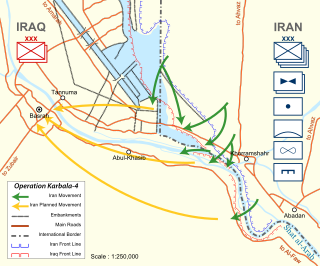
Operation Karbala-4 was an Iranian offensive in the Iran–Iraq War on the southern front. The operation was launched after the failure of Operation Karbala-2 and Operation Karbala-3 to move the Iraqi lines in an effort to capture Iraqi territory.

<span class="mw-page-title-main">Battle of Al Faw (2003)</span> Engagement of the Iraq War

The Battle of Al Faw was one of the first battles of the Iraq War; it took place March 20-24, 2003.

<span class="mw-page-title-main">Sheikhdom of Kuwait</span> Middle Eastern state (1752–1961)

The Sheikhdom of Kuwait was a sheikhdom which gained independence from the Khalidi Emirate of Al Hasa under Sabah I bin Jaber in the year 1752. The Sheikhdom became a British protectorate between 1899 and 1961 after the Anglo-Kuwaiti agreement of 1899 was signed between Sheikh Mubarak Al-Sabah and the British government in India due to threats to Kuwait's independence from the Ottoman Empire.

The Gulf War began on the 2 August 1990, when Iraq invaded Kuwait. The war was fought between the international coalition led by the United States of America against Iraq. Saddam Hussein's rationale behind the invasion is disputed and largely unknown. No Iraqi document has ever been discovered explicitly listing these.

References

  1. "UNLOCODE (IQ) - IRAQ". service.unece.org. Retrieved 24 April 2020.
  2. China’s Belt & Road Initiative
  3. Baghdad’s new route to Europe
  4. 1 2 3 4 "Umm Qasr". thepersiangulf.org. Archived from the original on 2009-02-24. Retrieved 2009-05-16.
  5. "Iraq Hopes For Revival As An International Highway", The Times, 15 May 1961
  6. "General Kassim Founds £15M. Port", The Times, 27 March 1961
  7. Ports of the World 1969, p. 697. Shipping World Ltd
  8. "Fierce battle around port," The Guardian, 24 March 2003
  9. "Iraq aid confined to south", The Guardian, 2 April 2003
  10. "Iraqi welcome for US turns to fury". theage.com.au. 2003-05-05. Retrieved 2009-05-16.
  11. 1 2 "Umm Qasr". globalsecurity.org. Retrieved 2009-05-16.