Related Research Articles
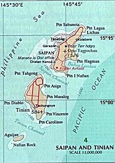
Tinian is one of the three principal islands of the Commonwealth of the Northern Mariana Islands. Together with uninhabited neighbouring Aguigan, it forms Tinian Municipality, one of the four constituent municipalities of the Northern Marianas. Tinian's largest village is San Jose.

The Mariana Islands are a crescent-shaped archipelago comprising the summits of fifteen mostly dormant volcanic mountains in the western North Pacific Ocean, between the 12th and 21st parallels north and along the 145th meridian east. They lie south-southeast of Japan, west-southwest of Hawaii, north of New Guinea and east of the Philippines, demarcating the Philippine Sea's eastern limit. They are found in the northern part of the western Oceanic sub-region of Micronesia, and are politically divided into two jurisdictions of the United States: the Commonwealth of the Northern Mariana Islands and, at the southern end of the chain, the territory of Guam. The islands were named after the influential Spanish queen Mariana of Austria following their colonization in the 17th century.

Rota, also known as the "Friendly Island", is the southernmost island of the United States Commonwealth of the Northern Mariana Islands (CNMI) and the second southernmost of the Marianas Archipelago. In early Spanish records it is called "Zarpana"; the name Rota may have come from the Spaniards possibly naming the island after the municipality of Rota, Spain. It lies approximately 40 nautical miles (74 km) north-northeast of the United States territory of Guam. Sinapalo village is the largest and most populated, followed by Songsong village (Songsong).

A latte stone, or simply latte, is a pillar capped by a hemispherical stone capital (tasa) with the flat side facing up. Used as building supports by the ancient Chamorro people, they are found throughout most of the Mariana Islands. In modern times, the latte stone is seen as a sign of Chamorro identity and is used in many different contexts.

This is a list of the buildings, sites, districts, and objects listed on the National Register of Historic Places in the Northern Mariana Islands. There currently 37 listed sites spread across the four municipalities of the Northern Mariana Islands. There are no sites listed on any of the islands that make up the Northern Islands Municipality.
Unai may refer to

Landing Beaches; Aslito/Isely Field & Marpi Point, Saipan Island is a National Historic Landmark District consisting of several discontiguous areas of the island of Saipan in the Northern Mariana Islands. The sites were designated for their association with the Japanese defense of Saipan during World War II, the 1944 Battle of Saipan in which Allied forces captured the island, and the subsequent campaigns which used Saipan as a base. The district includes the landing beaches where the Allies landed, the remnants of Japanese airfields Aslito and Marpi Point, and Isely Field, the Allied airfield built over much of Aslito from which B-29 bombers were used to bomb the Japanese home islands. Included in the Marpi Point area are Suicide Cliff and Banzai Cliff, two locations where significant numbers of Japanese military and civilians jumped to their deaths rather than surrender to advancing forces. The loss of Saipan was a major blow to the Japanese war effort, leading to the resignation of Prime Minister Hideki Tojo, The landmark designation was made in 1985.

The House of Taga is an archeological site located near San Jose Village, on the island of Tinian, United States Commonwealth of the Northern Mariana Islands, in the Marianas Archipelago. The site is the location of a series of prehistoric latte stone pillars which were quarried about 4,000 feet (1,200 m) south of the site, only one of which is left standing erect due to past earthquakes. The name is derived from a mythological chief named Taga, who is said to have erected the pillars as a foundation for his own house.
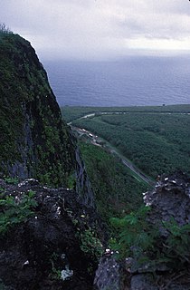
Suicide Cliff is a cliff above Marpi Point Field near the northern tip of Saipan, Northern Mariana Islands, which achieved historic significance late in World War II.
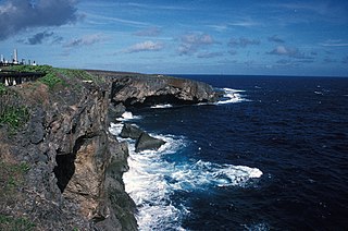
Banzai Cliff is a historic site at the northern tip of Saipan island in the Northern Mariana Islands, overlooking the Pacific Ocean. Towards the end of the Battle of Saipan in 1944, hundreds of Japanese civilians and soldiers jumped off the cliff to their deaths in the ocean and rocks below, to avoid being captured by the Americans. Not far away, a high cliff named Suicide Cliff overlooks the coastal plain, and was another site of numerous suicides. At Banzai Cliff, some who jumped did not die and were captured by American ships.
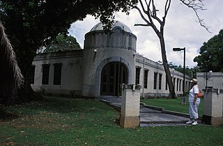
The Japanese Hospital or Saipan Byoin is a historic World War II-era hospital complex on Route 3 in Garapan, a village on the island of Saipan in the Northern Mariana Islands. The three concrete buildings are the largest Japanese-built structures to survive the war. The main hospital building is an L-shaped structure with a domed entrance at the crook of the L. A second, smaller building housed the pharmacy, while the third is an underground circular chamber of unknown purpose. All were in deteriorating condition when surveyed in the early 1970s. The complex has since undergone restoration, and the main hospital building now houses the Northern Mariana Islands Museum.

The Japanese Jail Historic and Archeological District in Garapan (Saipan), MP, is a historic district that was listed on the U.S. National Register of Historic Places in 2011. The listing included two contributing structures and 15 contributing sites. It includes ruins of a jail that was built in 1930 and was used until 1944.

The Campaneyan Kriso Rai, also known as the Catholic Belltower, is a historic church tower in Garapan, the largest village on Saipan island in the Northern Mariana Islands. Built in 1932, it is the only element of the island's most prominent Roman Catholic church to survive bombardment in World War II. The tower, a concrete structure 3 metres (9.8 ft) square and 10 metres (33 ft) tall, was built by Spanish Jesuits brought in by the Japanese South Pacific Mandate administration, and stood next to an 1860 wood-frame church.
The Dugi Archeological Site is a prehistoric latte stone site on the north side of Rota Island in the Northern Mariana Islands. The site is a rare inland site that survived the intensive sugar cane development introduced by the Japanese during the South Seas Mandate period of the 1920s and 1930s. It consists of sixteen deteriorated latte stone structures on three high terraces. Some of the latte stones have fallen over and others are missing features normally found at these sites.
Tachognya, also known as the Blue Site, is a prehistoric village site on the island of Saipan in the Northern Mariana Islands. It is located near the "Blue Beach" landing site of Allied forces in the Battle of Saipan, from which its name is derived. The site consists of ten latte stone house foundations, the largest of which has twelve latte columns and measures 14 by 58 feet.

The Laulau Kattan Latte Site is a prehistoric archaeological site on the island of Saipan in the Northern Mariana Islands. Located near the shore of Laulau Bay, it is a small village site containing the remains of four latte stone house foundations, and an extensive scattering of pottery artifacts. When first reported by the pioneering archaeologist Alexander Spoehr in the 1940s, the latte stones were described as mostly fallen over and extremely weathered.
Chalan Galaide is a late prehistoric latte stone archaeological site on the island of Saipan in the Northern Mariana Islands. It is unusual as one of the few inland latte sites in the Northern Marianas. It is a single-component site dating to the late prehistoric, or Latte Period, in the island's history. Based in part on the local name for the area and the presence of suitable tree species, it has been suggested the site was important in the production of canoes..
The Unai Achugao Archaeological Site is a major archaeological site on the island of Saipan in the Northern Mariana Islands. This site is one of the first sites at which reliable radiocarbon dates were acquired for the early habitation of the island, which were dated to about 3500 BCE. Excavations at the site also yielded more than 3,000 pottery fragments, which were used in the early classification of pottery types in the region. The site also included a nearly-intact habitation surface which was protected by a fossilized coral reef.

Mochong is a major prehistoric archaeological site on the island of Rota in the Northern Mariana Islands. It is considered the best preserved and largest latte village in the Marianas. ' It is an extensive village site on the northern side of the island with 47 latte stone house sites, including an extremely rare structure with 14 columns. It also has a latte stone wall, consisting of six columns and five slabs, that is more than 50 feet (15 m) long. The site has been radiocarbon dated to c. 1000 BCE. The site was first sketched in the early 19th century by the French explorer Louis de Freycinet, and was in remarkably intact condition in the 1980s.
References
- 1 2 "National Register Information System". National Register of Historic Places . National Park Service. July 9, 2010.
- ↑ Spoehr, Alexander (June 24, 1957). "MARIANAS PREHISTORY: Archaeological Survey and Excavations On Saipan, Tinian and Rota". Fieldiana (Volume 48). JSTOR 29782367.
| Topics | |
|---|---|
| Lists by state |
|
| Lists by insular areas | |
| Lists by associated state | |
| Other areas | |
| Related | |
| | This article about a property in the Northern Mariana Islands on the National Register of Historic Places is a stub. You can help Wikipedia by expanding it. |