The Helmand River is the longest river in Afghanistan and the primary watershed for the endorheic Sistan Basin. It originates in the Sanglakh Range of the Hindu Kush mountains in the northeastern part of Maidan Wardak Province, where it is separated from the watershed of the Kabul River by the Unai Pass. The Helmand feeds into the Hamun Lake on the border of Afghanistan and Iran.
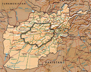
Hazarajat, also known as Hazaristan is a mostly mountainous region in the central highlands of Afghanistan, among the Kuh-e Baba mountains in the western extremities of the Hindu Kush. It is the homeland of the Hazara people who make up the majority of its population. Hazarajat denotes an ethnic and religious zone.

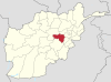
Maidan Wardak or Wardak, also called Wardag is one of the 34 provinces of Afghanistan, located in the central region of Afghanistan. It is divided into eight districts and has a population of approximately 500,000. The capital of the province is Maidan Shar, while the most populous district in the province is Saydabad District. Wardak is known for one of its famous high peak mountain known as.

The Kabul River, the classical Cophen, is a river that emerges in the Sanglakh Range of the Hindu Kush mountains in the northeastern part of Maidan Wardak Province, Afghanistan. It is separated from the watershed of the Helmand River by the Unai Pass. The Kabul River is a tributary of the Indus River, flowing into it near Attock, Pakistan. The Kabul is the main river in eastern Afghanistan and in the Khyber Pakhtunkhwa province of Pakistan.
The Sanglakh Range is an offshoot of the Hindu Kush, just west of Kabul in Maidan Wardak Province. Its main peak is the Unai; both the Helmand and Kabul rivers rise in the Sanglakh Range, separated by the Unai Pass.
Maidan Shar, also Maidan Shahr or simply Maidan, is the capital of Maidan Wardak province in central Afghanistan. Its population was estimated to be 35,008 in 2003, of which are Pashtuns, Hazaras and Tajiks.
The Logar River is a river of Afghanistan. It gives the name to the Logar Valley and Logar Province. In Maidan Wardak Province where the river originates, it is called Chak River. The Chaki Wardak Dam is built on the river in Chaki Wardak District, Maidan Wardak Province.

The Hajigak Pass is a mountain pass of Afghanistan. It is situated at a height of 3,700 metres (12,100 ft) above sea-level in the northern part of Maidan Wardak province, connecting it with Bamyan province to the northwest. It is one of the two main routes from Kabul to Bamyan in Hazarajat, leading across the Koh-i-Baba range.
Jalrez is a district in the west of Maidan Shar, Maidan Wardak Province, Afghanistan. The main town lies at Jalrez, which is 62.9 kilometres (39.1 mi) southwest of the centre of Kabul via the main Kabul-Behsud Highway. The district is a major producer of potatoes.
Day Mirdad is a district in the south of Wardak Province, Afghanistan. The capital of the district is Miran city. The district used to be known as Jilga.
Jaghatu is a district in Maidan Wardak province, Afghanistan, 20 km northwest of Ghazni. According to 2019 data, the population is 50,792. The district is within the heartland of the Wardak tribe of Pashtuns. Agriculture is the main source of income. The popular apples in Afghanistan is from this district. Drought has become a serious problem in the whole province. Health and education services are lacking although most of the people in this area have attempted to create schools and for students to attend with their own efforts.

Shibar Pass in Afghanistan is situated at a height of 3,000 metres (9,800 ft) above sea-level, connecting Parwan Province with Bamyan Province. It is the longer of the two main routes from Kabul to Bamiyan. The journey is approximately 6 and half hours long covering around 237 km (147 mi). It was originally designed and built by Ahmad Shah Shairzay and a German engineer between 1933 and 1938. It is noted to be an important mountain pass of the country.
Hisa-e-Awali Behsud is a district of Maidan Wardak Province, Afghanistan. The district has a Hazara majority resident population, but the district is also used as grazing ground by nomadic Pashtun Kuchis. The Hajigak Mine is located in the district.

Markaz-i Bihsūd District is one of the districts of Maidan Wardak Province in Afghanistan. It is located less than an hour-drive west of Kabul and south Bamyan. The main town in the district is Behsud. The district has an estimated population of 134,852 people, majority of which are ethnic Hazaras.
Kuchi–Hazara conflict is the series of conflicts between Kuchis and Hazaras over the lands in Hazarajat, the central highlands of Afghanistan, since the early 18th century. After the establishment of new Afghan Government, these conflicts have turned into war between Hazaras and Kuchis. The conflicts have left tens of people dead, hundreds injured and thousands internally displaced in recent years.
The Subdistricts of Afghanistan are the third-level administrative units of Afghanistan, subdivisions of the districts. They are known as "Alaqadari" and are the smallest administrative divisions. Each alaqadari is headed by an "alaqadar", appointed by the government in Kabul or a provincial governor.
Kot-e Ashro is a small town in the western Paghman Mountains of Jalrez District, Maidan Wardak Province, Afghanistan. It was formerly the district capital until it was taken by the Taliban in 2006. The town lies along the Kabul–Behsud Highway, 14.6 kilometres (9.1 mi) by road northwest of Maidan Shar.
Takana, also Takānah-ye Bālā, is a subdistrict and village of Jalrez District, Maidan Wardak Province, Afghanistan. It lies along the Kabul–Behsud Highway, to the west of the town of Jalrez.
The Kabul–Behsud Highway, formally National Highway 13, NH13, is a highway connecting Kabul in Afghanistan to Behsud in the west, passing through Maidan Wardak Province. It is cited as a highly dangerous route, prone to hijackings, beheadings, kidnappings and robberies, particularly in the districts of Jalrez and Markazi Bihsud, and has obtained the moniker "Death Road" due to the frequency of Taliban killings along the route.
The Battle Of Unai Pass took place at Unai Pass in 1929, during the Afghan Civil War when the Saqqawist army was trying to cross the Unai Pass to subjugate the Hazaras of Jang Kala. The battle was from June 28 to July 10, and several raids and offensives after that until the fall of the Saqqawists. The Hazara volunteers from Jang Kala under the leadership of Fateh Mohammad Khan defended their positions and launched a few attacks on the Saqqawists in Jalrez and the surrounding areas. The hordes of the Saqqawist army were successfully repelled by the Hazaras and the Saqqawist army retreated after many of them got killed or got captured. This was one of the battles recorded between the Hazaras and the Saqqawists when trying to enter Hazarajat