A sandbag or dirtbag is a bag or sack made of hessian (burlap), polypropylene or other sturdy materials that is filled with sand or soil and used for such purposes as flood control, military fortification in trenches and bunkers, shielding glass windows in war zones, ballast, counterweight, and in other applications requiring mobile fortification, such as adding improvised additional protection to armored vehicles or tanks.

Muhammad Bairam Khan, commonly known as Bairam Khan or Bayram Khan was an important military commander, and later commander-in-chief of the Mughal army, a powerful statesman and regent at the court of the Mughal Emperors, Humayun and Akbar. He was also the guardian, chief mentor, adviser, teacher and the most trusted ally of Akbar. Akbar honoured him as Khan-i-Khanan, which means "King of Kings". Bairam was originally called Bairam "Beg", but later became honoured as Khan. Bairam Khan was an aggressive general who was determined to restore Mughal authority in India.

The Arghun dynasty ruled over the area adjoining Southern Afghanistan and then the Sindh Sultanate from the late 15th century to the early 16th century. Arghun rule can be divided into two branches: the Arghun branch of Dhu'l-Nun Beg Arghun that ruled until 1554, and the Tarkhan branch of Muhammad Isa Tarkhan that ruled until 1593.
Badin is the main city and capital of Badin District in Sindh, Pakistan. It lies east of the Indus River. It is the 105th largest city in Pakistan. Badin is often called 'Sugar State' due to its production of sugar.

Thatta District is located in the southern area, locally called Laar, of the province of Sindh, Pakistan. Its capital is Thatta. It is home to a large necropolis of Makli. In 2013, several talukas were separated to form the new Sujawal District.
Jamshoro District, is a district of Sindh province, Pakistan. Jamshoro city is the capital while Kotri is the largest city of the Jamshoro District. The district borders Dadu district to the north. To the east, the Indus separates it from Shaheed Benazirabad, Matiari and Hyderabad districts. Thatta district lies to the south, and Karachi district to the south west. To the west, the Kheerthar Range separates it from the Sindh and Hub district of Baluchistan.

Makli Necropolis is one of the largest funerary sites in the world, spread over an area of 10 kilometres near the city of Thatta, in the Pakistani province of Sindh. The site houses approximately 500,000 to 1 million tombs built over the course of a 400-year period. Makli Necropolis features several large funerary monuments belonging to royalty, various Sufi saints, and esteemed scholars. The site was inscribed as a UNESCO World Heritage Site in 1981 as an "outstanding testament" to Sindhi civilization between the 14th and 18th centuries.

Mahabat Khan, born Zamana Beg, was a prominent Mughal general and statesman, perhaps best known for his coup against the Mughal Emperor Jahangir in 1626. He also served Subahdar of Malwa Subah from 1611 to 1623 and Bengal Subah during 1625–1626. He earned the title Khan-i-Khanan from emperor Shah Jahan.
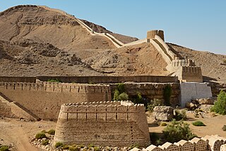
Agham Kot, historically known as Agham and today also called Aghamani or Aghamano, is a historical city and present-day ruin site located in Badin District, Sindh, Pakistan. It is located about 1.5 km northwest of the current town of Ghulab Khan Laghari, near the border with Hyderabad District. Said to be named after its 7th-century founder, the Lohana king Agham Lohana, Agham Kot historically lay on the right bank of the Dhoro, a branch of the Indus River that is now dried up. Because of this strategic location on an important waterway, Agham Kot was an important commercial centre in its heyday.
Tando Bago is a town and union council in Badin District, Sindh, Pakistan. The Tehsil (township) of Tando Bago had a population of 321,818 in 2008. The Sindh government operates approximately 589 schools in Tando Bago.

Badi' al-Zaman Mirza was a Timurid ruler of Herat from 1506 to 1507. He was the son of Husayn Bayqarah, who was a great-great-grandson of Timur.
Sann is a small town and union council located in Manjhand taluka of Jamshoro District, Sindh Province, Pakistan. It lies on the western bank of the Indus river, at the mouth of an intermittent stream that brings down water from the Lakhi hills when it rains. The town is located midway between Manjhand and Amri on the main Sehwan-Kotri trunk road.
In 1573, Mughal Emperor Akbar conquered Gujarat Sultanate taking advantage of young Gujarat Sultan Muzaffar Shah III and his quarrelling nobles. Muzaffar was held captive at Agra. He appointed his foster brother Mírza Âzíz Kokaltásh as the first viceroy who faced an insurrection by the rebel nobles of the former Sultanate. Akbar quickly came to aid and ended the insurrection. He soon appointed Mírza Khán who managed to set revenue system and quelled attack by the Mirzas with help of Mughal minister Todar Mal. The next viceroy Shaháb-ud-dín strengthened the military. Soon Sultan Muzaffar escaped, returned to Gujarat and led an attack on Ahmedabad and recaptured it before his former noble and now viceroy Itimad Khan reach the city. Soon Mirza Khan was reappointed as the viceroy who defeated Muzaffar in the battle of Fatehwadi in 1584. Soon Kokaltásh returned as the viceroy and defeated Muzaffar and combined Kathiawad forces in battle of Bhuchar Mori. Later Muzaffar was captured but he committed suicide, putting an end to the Gujarat Sultanate. As Kokaltásh went to the Mecca on pilgrimage, Sultan Murad Bakhsh was appointed as the viceroy on whose death, Kokaltásh returned third time as the viceroy. Akbar was succeeded by Jehangir.
Talti is a town and union council in Sehwan taluka of Jamshoro District, Sindh. It is located in the historical pargana of Baghban, 8 miles north of Sehwan and 2 miles off the main road from Sehwan to Larkano. It also has road connections with nearby Bhan and Bubak. There is a dhandh near Talti that is used as a source of fishery.
Bubak is a town and union council in Sehwan taluka of Jamshoro District, Sindh. It is located on the northeastern shore of Lake Manchar, 9 miles west of Sehwan. Besides Sehwan, it is connected by road with Bhan and Talti.
Kakrala was a historical region in southern Sindh, in the coastal parts of the Indus Delta. Descriptions of its precise extent vary, but it lay in the middle part of the delta, comprising the present-day taluqas of Shahbandar and Jati in Sujawal and Thatta districts. It has been described as the region from Jati to Kharo Chan, or the region between the mouths of the Wanyani and Pitti rivers. This area later formed part of the pargana of Ghorabari.
Chandūka, also spelled Chāndkoh or Chāndko, was a historical region in Sindh, roughly corresponding to the Larkana subdivision as it existed in the early 20th century. It was an alluvial tract on the right bank of the Indus with its main town at Ghaibi Dero. S.H. Hodivala also wrote in 1939 that Chanduka was then the name of the main town in Larkana District. Chanduka is named after the Baluch tribe known as the Chandias.

Shaykh ʿAbdul Wāḥid was a military general of the Mughal Empire during the reign of Jahangir, and played an important role in defeating Bahadur Ghazi, who was among the rebellious Baro-Bhuiyans of Bengal. He is celebrated as the Mughal conqueror of Bhulua as he was the chief commander of its expedition. His administration of the Bhulua frontier involved suppressing multiple Arakanese invasions, later earning him the title of Sarḥad Khān.
Babbar, Babur, Babar is a Baloch tribe which lives in Northern Sindh, Balochistan and Dera Ghazi Khan division of Punjab. It is also found in the Pishin District of Rask County, Sistan and Baluchestan province, Iran. The Mughal author "Yūsuf Mīrak" described the Babbars in his historical account of Sindh the "Tareekh-e-Mazhar-e-Shah-e-Jahani", as a rebellious Baloch tribe inhabiting the Kirthar mountains westwards of the present day Jamshoro district of Sindh.

Mirza Jani Beg Tarkhan was the last Sultan of Sindh. He succeeded his grandfather Mirza Muhammad Baqi after his death. He ruled from 1585 to 1591 as an independent monarch of Sindh but was forced to submit to Mughal authority. He later involuntarily abdicated in 1593 and a Mughal Subahdar was appointed in his place. But due to social and public unrest, the Mughal authority appointed Jani in his place in 1594. Jani continued to serve as the Mughal Subahdar till his death in 1601.