Chhatarpur is a city and a municipality in Chhatarpur district in the state of Madhya Pradesh, India. It is the administrative headquarters of Chhatarpur District. Chhatarpur is a city and a municipality in Chhatarpur district in the state of Madhya Pradesh, India. It is the administrative headquarters of Chhatarpur District.

Datia is the district headquarter of the Datia District in north central Madhya Pradesh,a state of Central India. It is an ancient town, mentioned in the Mahabharata ruled by King Dantavakra. The city is 78 km from Gwalior, 325 km south of New Delhi and 344 km north of Bhopal. About 18 km from Datia is Sonagiri, a sacred Jain hill. Datia is also about 31 km from Jhansi and 52 km from Orchha. The nearest airport is at Gwalior. It was formerly the seat of the eponymous princely state in the British Raj. Datia is situated near Gwalior and on the border with Uttar Pradesh.
Umaria district is a district of Madhya Pradesh. The town of Umaria is the district headquarters. The district is part of Shahdol Division.
Satna is a city in the Indian state of Madhya Pradesh. It serves as the headquarters of Satna district. It is 7th largest city and 8th most populous city of the state. The city is 500 km east of the state capital Bhopal. The city is distributed over a land area of 111.9 square kilometres.

Budhni, also spelled Budni or Budhani, is a town and a Nagar Palika in Sehore district in the state of Madhya Pradesh, India. It is situated on Bhopal to Narmadapuram road at a distance of 7 km from Narmadapuram in north direction on the banks of Narmada River.It is also famous for Tractor testing i.e. CFMTTI (Institute under central government or Tractor Nagar.
Bhander is a town and a nagar panchayat in Datia district in the state of Madhya Pradesh.
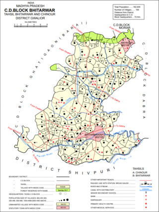
Bhitarwar is a city and a Municipality in Gwalior district in the state of Madhya Pradesh, India. The town is surrounded by a river called Parbati.
Gormi is a block and a nagar panchayat in Bhind district in the Indian state of Madhya Pradesh. Gormi is located at 26.6°N 78.52°E..
Jirapur is a town and a nagar panchayat in Rajgarh district in the Indian state of Madhya Pradesh. In 2022 Janpad Panchayat election held across Madhya Pradesh, Congress won the election and secure position as a Janpad Adhyaksh under the leadership of Khilchipur vidhayak Shri Priyavrat Singh Ji. He put all the efforts to win this election and doing great work for Khilchipur constituency. He won 2018 assembly election of Madhya Pradesh with huge margin of 30,000+ votes by defeating Kunwar Hajarilal Dangi of Bharatiya Janata Party (BJP) candidate.
Manohar Thana is a census town in Jhalawar district in the Indian state of Rajasthan. This town in Jhalawar district, located in the southeast of Rajasthan. It is situated at a short distance from the Rajasthan - Madhya Pradesh border and about 12 km from the town to the Madhya Pradesh border. Manohar Thana is Gram Panchayat and Panchayat Samiti, Tehsil comes under Manohar Thana. This village is surrounded by three more rivers. From two sides it is surrounded by the Ghodapachhad river coming from Madhya Pradesh and Parvan river from another. Outside the village, Kalikhad joins the Parvan River, which is called the Sangam Sthal.
Mundi is a city and Tehsil in the Khandwa district of Nimar region the Indian state of Madhya Pradesh. It is situated in North Side of East Nimar District.
Naraini is a town and Nagar panchayat in Banda district in the Indian state of Uttar Pradesh. It is the one of the four tehsils of Banda District.
Nowrozabad or Khodargama is a town and a Nagar Palika in Umaria district in the Indian state of Madhya Pradesh. Kendriya Vidyalaya Nowrozabad is situated in the G.M Complex Johila area. Nowrozabad is the head office of Johila area. The nearest Airport is at Jabalpur in Madhya pradesh. Nowrozabad Railway Station is on the Katni - Anuppur rail route. There are many coal mines around here. National Highway 43 has its route through Nowrozabad.
Obedullaganj is a town and a nagar panchayat in Raisen district in the Indian state of Madhya Pradesh. It is situated 70 km from its district headquarter Raisen and 36 km from its state capital city Bhopal.
Pachore is a Tahsil Place and a nagar panchayat in Rajgarh district of Madhya Pradesh in India. It is situated on Agra-Bombay Road - NH 52 at the bank of the river Nevaj. Pachore Mandi is the biggest Mandi of Rajgarh District.
Sarangpur is a city and tehsil in Rajgarh district in the Indian state of Madhya Pradesh. It is situated at the bank of the river Kali Sindh.
Satwas is a town and a Nagar Panchayat in Dewas district in the Indian state of Madhya Pradesh. Satwas is around 136.8 km (85.0 mi) from Dewas.
Satna District is a district of Madhya Pradesh state in central India. The city of Satna is the district headquarters. The district has an area of 7,502 km², and a population of 22,28,935(2011 census), 20.63% of which is urban. The district has a population density of 249 persons per km².
Dongargaon, Agar Malwa is a town and a Gram Panchayat, near town of Agar in Agar Malwa district in the Indian state of Madhya Pradesh. It is located on the Indore–Kota National Highway on the bank of Kali Sindh River. It is surrounded by the border with the state of Rajasthan from three sides and is a well-known center of transport business between the two states.
Kenud is a village of the Punasa tehsil of Khandwa district, in Madhya Pradesh state, India. The village is almost three hundred years old. Which was founded around 1700 AD by Joraji Singh Badal. Most of the people of the village depend on agriculture, workers and youth are dependent on the nearby city of Mundi and Shree Singaji Thermal Power Project for employment.