United Nations station is served by buses, jeepneys, and UV Express along Taft Avenue and other nearby routes. Regular taxis and cycle rickshaws also stop at and near the station.
Gallery
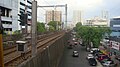
Overview of United Nations, Manila, from United Nations LRT station
Ermita is a district in Manila, Philippines. Located at the central part of the city, the district is a significant center of finance, education, culture, and commerce. Ermita serves as the civic center of the city, bearing the seat of city government and a large portion of the area's employment, business, and entertainment activities.
Blumentritt station is an elevated Light Rail Transit (LRT) station located on the LRT Line 1 (LRT-1) system in Manila, Philippines. The station serves the districts of Tondo, Santa Cruz, and Sampaloc. The station is situated near Blumentritt Road and is named after it. The street itself is named to honor Bohemian professor Ferdinand Blumentritt, one of José Rizal's closest associates and a sympathizer of the Propaganda Movement.
Doroteo Jose station is an elevated Light Rail Transit (LRT) station located on the LRT Line 1 (LRT-1) system in Santa Cruz, Manila. The station is situated on Rizal Avenue and slightly past Doroteo Jose Street. Both the station and the street are named after Doroteo Jose, a Filipino who was arrested by Spanish authorities in 1898 for leading a movement against a corrupt archbishop.
Central Terminal is an elevated Light Rail Transit (LRT) station located on the LRT Line 1 (LRT-1) system in Ermita, Manila. A popular name for the station is Arroceros due to its proximity to the Arroceros Forest Park.
Gil Puyat station is an elevated Light Rail Transit (LRT) station located on the LRT Line 1 (LRT-1) system in Pasay, Philippines. It is named after Gil Puyat Avenue, immediately over which the station lies. The avenue itself is named after Gil Puyat, a former senator and statesman.
EDSA station is an elevated Light Rail Transit (LRT) station located on the LRT Line 1 (LRT-1) system in Pasay. The station is situated on the intersection of Taft Avenue and Epifanio de los Santos Avenue, better known as EDSA, one of Metro Manila's major thoroughfares. The station and the avenue are both named after Epifanio de los Santos, a noted historian.
Baclaran station is an elevated Light Rail Transit (LRT) station located on the LRT Line 1 (LRT-1) system in Pasay. Situated on the last stretches of Taft Avenue right at the border with Baclaran, Parañaque, it is the current southern terminus of the line. The terminal is named after the famous shopping district of the same name, which is located on the borders of the cities of Pasay and Parañaque.
Vito Cruz station is an elevated Light Rail Transit (LRT) station located on the LRT Line 1 (LRT-1) system in Malate, Manila. It is the first station from Baclaran and the last station from Fernando Poe Jr. to lie within Manila city bounds. The station takes its name from the former Vito Cruz Street, which was named after a former alcalde mayor of Pineda c. 1871.
Carriedo station is an elevated Light Rail Transit (LRT) station located on the LRT Line 1 (LRT-1) system along the district boundary of Santa Cruz and Quiapo in Manila.
Libertad station is an elevated Light Rail Transit (LRT) station located on the LRT Line 1 (LRT-1) system in Pasay, Metro Manila, Philippines. It is situated at the intersection of Taft Avenue and Arnaiz Avenue. The station is named after the former Libertad Street, now a part of Arnaiz Avenue. The name Libertad survives as an area name after the old street.
Pedro Gil station is an elevated Light Rail Transit (LRT) station located on the LRT Line 1 (LRT-1) system in Ermita, Manila, Philippines. It is situated at the corner of Taft Avenue and Pedro Gil Street. The station takes its name from Pedro Gil Street, which used to be called Herran Street.
Quirino station is an elevated Light Rail Transit (LRT) station located on the LRT Line 1 (LRT-1) system in Malate, Manila Philippines. It is situated at the meeting point of Taft Avenue, San Andres Street and Quirino Avenue. The station and Quirino Avenue are both named after former president Elpidio Quirino.
Boni station is an at-grade Metro Rail Transit (MRT) station located on the MRT Line 3 (MRT-3) system in Mandaluyong. It is named so due to its proximity to Boni Avenue, which is in turn named after the nickname of Bonifacio Javier, a World War II guerilla leader and former mayor of Mandaluyong. It has several restaurants and shops that surround the station, including a public market located across the train station.
Abad Santos station is an elevated Light Rail Transit (LRT) station located on the LRT Line 1 (LRT-1) system in Manila, Philippines. The station serves Tondo and Santa Cruz, and is situated on Rizal Avenue. The station is named after the nearby Abad Santos Avenue, which in turn, is named after José Abad Santos, Chief Justice of the Supreme Court of the Philippines who was executed by the Japanese invading forces during World War II.
Bambang station is an elevated Light Rail Transit (LRT) station located on the LRT Line 1 (LRT-1) system in Santa Cruz, Manila. The station is situated on Rizal Avenue. The station is named after Bambang Street, which is adjacent to the station.
R. Papa station is an elevated Light Rail Transit (LRT) station located on the LRT Line 1 (LRT-1) system in Tondo, Manila, Philippines. It is situated on Rizal Avenue Extension in Barrio Obrero. The station is named after Ricardo Papa Street, which is in turn named after a former Manila police chief-turned-Commanding General of the Philippine Army. The station is the first station in Rizal Avenue Extension going north and the last in the city of Manila.
5th Avenue station is an elevated Light Rail Transit (LRT) station located on the LRT Line 1 (LRT-1) system in Caloocan, Philippines. The station is situated on Rizal Avenue Extension at the boundaries of Grace Park East and Grace Park West. The station is located above the avenue's intersection with 5th Avenue (C-3), after which the station is named.
Taft Avenue is a major road in the south of Metro Manila. It passes through three cities in the metropolis: Manila, Pasay, and Parañaque. The road was named after the former Governor-General of the Philippines and U.S. President, William Howard Taft; the Philippines was a former commonwealth territory of the United States in the first half of the 20th century. The avenue is a component of National Route 170 (N170), a secondary road in the Philippine highway network and the entirety R-2 of the Manila arterial road network.
United Nations Avenue is a major thoroughfare in Manila, Philippines. A commercial, residential and industrial artery, the avenue runs east–west through the near-center of the city linking Ermita and Rizal Park with the eastern districts. It is home to the World Health Organization Western Pacific headquarters.
Pablo Ocampo Street, also known simply as Ocampo Street and formerly and still referred to as Vito Cruz Street, is an inner city main road in Manila, Philippines. It runs west–east for about 3.448 kilometers (2.142 mi) connecting the southern districts of Malate and San Andres southeast to the adjacent city of Makati.
This page is based on this Wikipedia article Text is available under the CC BY-SA 4.0 license; additional terms may apply. Images, videos and audio are available under their respective licenses.