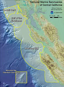
The Channel Islands National Marine Sanctuary is a sanctuary off the coast of Santa Barbara and Ventura counties in Southern California 350 miles south of San Francisco and 95 miles north of Los Angeles. It was designated in 1980 by the National Oceanic and Atmospheric Administration.

The Northwestern Hawaiian Islands or Leeward Hawaiian Islands are a series of islands and atolls in the Hawaiian island chain located northwest of the islands of Kauai and Niʻihau. Politically, they are all part of Honolulu County in the U.S. state of Hawaii, except Midway Atoll, which is a territory distinct from the State of Hawaii, and grouped as one of the United States Minor Outlying Islands. The United States Census Bureau defines this area, except Midway, as Census Tract 114.98 of Honolulu County. Its total land area is 3.1075 square miles (8.048 km2). All the islands except Nihoa are north of the Tropic of Cancer, making them the only islands in Hawaii that lie outside the tropics.
The National Ocean Service (NOS) is an office within the U.S. Department of Commerce, National Oceanic and Atmospheric Administration (NOAA). It is responsible for preserving and enhancing the nation's coastal resources and ecosystems along approximately 95,000 miles (153,000 km) of shoreline, that is bordering 3,500,000 square miles (9,100,000 km2) of coastal, Great Lakes and ocean waters. Its mission is to "provide science-based solutions through collaborative partnerships to address evolving economic, environmental, and social pressures on our oceans and coasts." The office works with partnered agencies to ensure that ocean and coastal areas are safe, healthy, and productive. It`s projects focus on working to ensure safe and efficient marine transportation, promoting the protection of coastal communities, conserving marine and coastal places. It employs 1,700 scientists, natural resource managers, and specialists in many different fields. The National Ocean Service was previously known as the National Ocean Survey until it was renamed in 1983.

A marine reserve is a type of marine protected area (MPA). An MPA is a section of the ocean where a government has placed limits on human activity. A marine reserve is a marine protected area in which removing or destroying natural or cultural resources is prohibited, marine reserves may also be "no-take MPAs,” which strictly forbid all extractive activities, such as fishing and kelp harvesting. As of 2007 less than 1% of the world's oceans had been set aside in marine reserves. Benefits include increases in the diversity, density, biomass, body size and reproductive potential of fishery and other species within their boundaries.
A U.S. National Marine Sanctuary is a zone within United States waters where the marine environment enjoys special protection. The program was established in 1972 by the Marine Protection, Research, and Sanctuaries Act and is currently administered by the National Ocean Service through the National Marine Sanctuaries Act (NMSA).

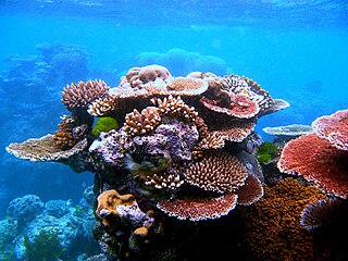
Southeast Asian coral reefs have the highest levels of biodiversity for the world's marine ecosystems. They serve many functions, such as forming the livelihood for subsistence fishermen and even function as jewelry and construction materials. Corals inhabit coastal waters off of every continent except Antarctica, with an abundance of reefs residing along Southeast Asian coastline in several countries including Indonesia, the Philippines, and Thailand. Coral reefs are developed by the carbonate-based skeletons of a variety of animals and algae. Slowly and overtime, the reefs build up to the surface in oceans. Coral reefs are found in shallow, warm salt water. The sunlight filters through clear water and allows microscopic organisms to live and reproduce. Coral reefs are actually composed of tiny, fragile animals known as coral polyps. Coral reefs are significantly important because of the biodiversity. Although the number of fish are decreasing, the remaining coral reefs contain more unique sea creatures. The variety of species living on a coral reef is greater than anywhere else in the world. An estimation of 70-90% of fish caught are dependent on coral reefs in Southeast Asia and reefs support over 25% of all known marine species. However, those sensitive coral reefs are facing detrimental effects on them due to variety of factors: overfishing, sedimentation and pollution, bleaching, and even tourist-related damage.
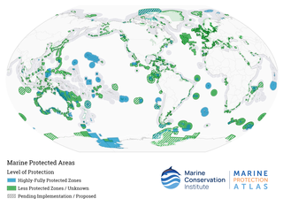
Marine protected areas (MPA) are protected areas of the world's seas, oceans, estuaries or in the US, the Great Lakes. These marine areas can come in many forms ranging from wildlife refuges to research facilities. MPAs restrict human activity for a conservation purpose, typically to protect natural or cultural resources. Such marine resources are protected by local, state, territorial, native, regional, national, or international authorities and differ substantially among and between nations. This variation includes different limitations on development, fishing practices, fishing seasons and catch limits, moorings and bans on removing or disrupting marine life. In some situations, MPAs also provide revenue for countries, potentially equal to the income that they would have if they were to grant companies permissions to fish. The value of MPA to mobile species is unknown.
The Virgin Islands Coral Reef National Monument is a U.S. National Monument located off Saint John, Virgin Islands.

Marine conservation, also known as ocean conservation, is the protection and preservation of ecosystems in oceans and seas through planned management in order to prevent the over-exploitation of these marine resources. Marine conservation is informed by the study of marine plants and animal resources and ecosystem functions and is driven by response to the manifested negative effects seen in the environment such as species loss, habitat degradation and changes in ecosystem functions and focuses on limiting human-caused damage to marine ecosystems, restoring damaged marine ecosystems, and preserving vulnerable species and ecosystems of the marine life. Marine conservation is a relatively new discipline which has developed as a response to biological issues such as extinction and marine habitats change.

The Golden Gate Biosphere Network is a voluntary coalition of federal, state, and local government agencies, nonprofit organizations, universities, and private partners within the Golden Gate Biosphere region. The Network works towards protecting the biosphere region's biodiversity and conserving its natural resources to maintain the quality of life for people within the region. The Network has been part of the UNESCO Man and Biosphere Programme since 1988 and is part of the US Biosphere Network and EuroMAB. It is recognized by UNESCO due to the significant biodiversity of the region, as well as the Network's efforts to demonstrate and promote a balanced relationship between humans and the biosphere.

The Papahānaumokuākea Marine National Monument (PMNM) is a World Heritage listed U.S. National Monument encompassing 583,000 square miles (1,510,000 km2) of ocean waters, including ten islands and atolls of the Northwestern Hawaiian Islands. It was created in June 2006 with 140,000 square miles (360,000 km2) and expanded in August 2016 by moving its border to the limit of the exclusive economic zone, making it one of the world's largest protected areas. It is internationally known for its cultural and natural values as follows:
The area has deep cosmological and traditional significance for living Native Hawaiian culture, as an ancestral environment, as an embodiment of the Hawaiian concept of kinship between people and the natural world, and as the place where it is believed that life originates and to where the spirits return after death. On two of the islands, Nihoa and Mokumanamana, there are archaeological remains relating to pre-European settlement and use. Much of the monument is made up of pelagic and deepwater habitats, with notable features such as seamounts and submerged banks, extensive coral reefs and lagoons.
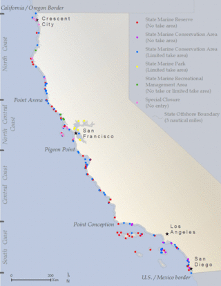
The Marine Life Protection Act(MLPA) was passed in 1999 and is part of the California Fish and Game Code. The MLPA requires California to reevaluate all existing marine protected areas (MPAs) and potentially design new MPAs that together form a statewide network. The MLPA has clear guidance associated with the development of this MPA network. MPAs are developed on a regional basis with MLPA and MPA-specific goals in mind and are evaluated over time to assess their effectiveness in meeting these goals. The five main goals of the Marine Life Protection Act are to maintain the diversity of marine ecosystems, conserve its populations, better educate people on human-marine life interactions, protect habitats, and effectively enforce MPAs. The establishment of this policy is an important step in expanding science-based management and decision making regarding policies.
Coral reef protection is the process of modifying human activities to avoid damage to healthy coral reefs and to help damaged reefs recover. The key strategies used in reef protection include defining measurable goals and introducing active management and community involvement to reduce stressors that damage reef health. One management technique is to create Marine Protected Areas (MPAs) that directly limit human activities such as fishing.
Wakatobi National Park is a marine national park in Southeast Sulawesi, Indonesia. The name of Wakatobi is a portmanteau of the four main Tukangbesi Islands: Wangi-wangi, Kaledupa, Tomia, and Binongko. Since 2005 the park is listed as a tentative World Heritage Site.

IUCN protected area categories, or IUCN protected area management categories, are categories used to classify protected areas in a system developed by the International Union for Conservation of Nature (IUCN).
Marine Conservation Institute is a tax-exempt nonprofit ocean conservation organization working to identify and protect vulnerable ocean ecosystems worldwide. The organization is headquartered in Seattle, Washington, with offices in Washington, D.C., and Glen Ellen, California.
The St. Croix East End Marine Park (STXEEMP) was established to "protect territorially significant marine resources, and promote sustainability of marine ecosystems, including coral reefs, sea grass beds, wildlife habitats and other resources, and to conserve and preserve significant natural areas for the use and benefit of future generations." It is the U.S. Virgin Islands’ first territorially designated and managed marine protected area (MPA).

The Marine Policy of the Barack Obama administration comprises several significant environmental policy decisions for the oceans made during his two terms in office from 2009 to 2017. By executive action, US President Barack Obama increased fourfold the amount of protected marine space in waters under United States control, setting a major precedent for global ocean conservation. Using the U.S. president's authority under the Antiquities Act of 1906, he expanded to 200 nautical miles the seaward limits of Papahānaumokuākea Marine National Monument in Hawaiʻi and the Pacific Remote Islands Marine National Monument around the U.S. island possessions in the Central Pacific. In the Atlantic, Obama created the Northeast Canyons and Seamounts Marine National Monument, the first marine monument in the U.S. exclusive economic zone (EEZ) in the Atlantic.
The marine protected areas of South Africa are in an area of coastline or ocean within the exclusive economic zone (EEZ) of the Republic of South Africa that is protected in terms of specific legislation for the benefit of the environment and the people who live in and use it. An MPA is a place where marine life can thrive under less pressure than unprotected areas. They are like underwater parks, and this healthy environment can benefit neighbouring areas.

Coral Reef Conservation Program (CRCP) is a partnership between National Oceanic and Atmospheric Administration (NOAA) agencies, established in 2000. The program is a multidisciplinary approach, initiated by the NOAA, to managing and understanding coral reef ecosystems through research and the publication of data to support relevant partners involved in coral reef restoration.