Deerhurst is a village and civil parish in Gloucestershire, England, about 2 miles (3 km) southwest of Tewkesbury. The village is on the east bank of the River Severn. The parish includes the village of Apperley and the hamlet of Deerhurst Walton. The 2011 Census recorded the parish's population as 906, the majority of whom live in Apperley.

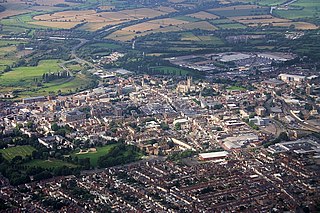
Newent is a small market town and civil parish about 10.6 miles (17.1 km) north west of Gloucester in Gloucestershire, England. Its population at the 2001 census was 5,073, increasing to 5,207 at the 2011 census. The town's site has been settled since at least Roman times and appears first in the historical record in the Domesday Book. It was a Medieval market and fair town.

Bibury is a village and civil parish in Gloucestershire, England. It is on both banks of the River Coln which rises in the same (Cotswold) District and which is a Thames tributary. The village is centred 6 1⁄2 miles (10 km) northeast of Cirencester. Arlington Row here is a nationally notable architectural conservation area depicted on the inside cover of all United Kingdom passports. It is a major destination for tourists visiting the traditional rural villages, tea houses and many historic buildings of the Cotswold District and is regarded as one of the most beautiful villages in England. It is one of six places in the country featured in Mini-Europe, Brussels. Bibury is also famous as Emperor Hirohito's favourite place in England and as the home of the Birtwistles.

Newnham on Severn is a village in west Gloucestershire, England. It lies in the Royal Forest of Dean, on the west bank of the River Severn, approximately 10 miles south-west of Gloucester and three miles southeast of Cinderford. It is on the A48 road between Gloucester and Chepstow, Monmouthshire, Wales. The village has a parish council.

Aldenham is a village and civil parish in Hertfordshire, 3.5 miles (5.6 km) north-east of Watford and 2 miles (3.2 km) southwest of Radlett. It was mentioned in the Domesday Book and is one of Hertsmere's 14 conservation areas. This secluded little village has eight pre-19th century buildings that are listed buildings and the parish itself is largely unchanged, though buildings have been rebuilt, since Saxon times when the majority of the land was owned by the abbots of Westminster Abbey.

Aldsworth is a village and civil parish in the Cotswold district of Gloucestershire, about ten miles north-east of Cirencester. In 2010 its population was 236. Aldsworth is a large parish, slightly north of the River Leach, located in the South West of the United Kingdom. The Parish was once a possession of the Abbey Of Gloucester.
Alvington is a village and civil parish in the Forest of Dean in Gloucestershire, England, situated on the A48 road, six miles north-east of Chepstow in Wales. The parish had a total population of 506 at the 2011 census.

Arlingham is a village and civil parish in the Stroud District of Gloucestershire, England. The 2001 Census recorded a parish population of 410, increasing to 459 at the 2011 census. The parish contains the hamlets of Milton End, Overton and Priding The next parish to the east is Fretherne with Saul.

Ashleworth is a village and civil parish in the Tewkesbury district of Gloucestershire, England, with a population of 540, about six miles north of Gloucester. It has a riverside pub, the Boat Inn. The oldest part of the village is Ashleworth Quay, on a flood plain on the west bank of the River Severn.

English Bicknor is a village and civil parish in the Forest of Dean district of west Gloucestershire, England. The 2011 Census recorded the population as 408. The village is near the county boundary with Herefordshire, opposite which is the village of Welsh Bicknor. The two villages are on opposite sides of the River Wye.

Lower Oddington and Upper Oddington are a pair of adjoining villages in the English county of Gloucestershire. Together they form the civil parish of Oddington. In 2010 the parish had an estimated population of 477, decreasing at the 2011 census to 417.

Holy Trinity Church is a Church of England parish church in Westbury-on-Trym, Bristol, England.

Upper Slaughter is a village in the Cotswold district of Gloucestershire, England, 4 miles (6.4 km) south west of Stow-on-the-Wold. Nearby places include Lower Slaughter, Bourton-on-the-Water and Daylesford.

Miserden is a village and civil parish in Stroud District, Gloucestershire, England, 4 miles north east of Stroud. The parish includes Whiteway Colony and the hamlets of Sudgrove and The Camp. In the 2001 census the parish had a population of 420, increasing to 449 at the 2011 census.

Sedgeberrow is a village and civil parish in the Wychavon district of Worcestershire, England, about 3 miles (4.8 km) south of Evesham. It stands beside the River Isbourne, a tributary of the River Avon.

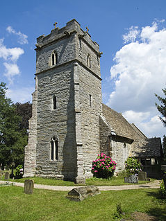
St Michael's and All Angels Church is in the village of Guiting Power, Gloucestershire, England. It is an active Anglican parish church in the deanery of Stow, the archdeaconry of Cheltenham and the diocese of Gloucester. Its benefice is combined with those of St Faith, Farmcote, St Mary, Lower Slaughter, St Andrew, Naunton, St Mary, Temple Guiting, St James, Cutsdean, and St Peter, Upper Slaughter. The church contains fabric dating from the 12th century and is recorded in the National Heritage List for England as a designated Grade II* listed building. It formerly stood in the centre of the village, but the demolition of buildings since 1900 has left it standing at the village's southern end.

St Nicholas of Myra's Church is a redundant Anglican church in the village of Ozleworth, Gloucestershire, England, in the care of The Churches Conservation Trust.. It is recorded in the National Heritage List for England as a designated Grade II* listed building. The church is unusual because it is one of only two churches in Gloucestershire with a hexagonal tower, the other being St Lawrence's Church in Swindon. You can find the church by following signs for 'Historic Church' and for Newark Park nearby. By car, park outside the Ozleworth Estate, near to the gates, and follow a long bridle path downhill and around to the left until you reach the churchyard. Please note - the path can be muddy and slippery.
Hasfield is a civil parish in Gloucestershire,England, and lies six miles (9.7 km) south-west of Tewkesbury and seven miles (11 km) north of Gloucester. It is situated on the west bank of the River Severn with much of its land residing below the 50-foot contour and as such subject to regular flooding. Hasfield is represented by the county councillor for Severn Vale division and the two borough councillors for Highnam with Haw Bridge ward on Tewkesbury Borough Council.

North Cerney is a village and civil parish in the English county of Gloucestershire, and lies within the Cotswolds, a range of hills designated an Area of Outstanding Natural Beauty. The village is 4 miles (6.4 km) north of Cirencester within the Churn valley. It was recorded as Cernei in the Domesday Book. However, the North Cerney parish boundaries were known to exist in 852 AD when it was recorded that King of the Mercians granted lands in North Cerney to a man called Alfeah.

Hampnett is a small village and civil parish in Gloucestershire, England, just west of the Fosse Way. It is situated west of the junction of the A40 and A429 roads in the Cotswolds Area of Outstanding Natural Beauty. A number of springs in the village form the source of the River Leach.