Upper Camster

Last updated

Upper Camster
Caithness UK location map.svg
Red pog.svg
Upper Camster
Location within the Caithness area
OS grid reference ND262414
Council area
Country Scotland
Sovereign state United Kingdom
Postcode district KW3 6
Police Scotland
Fire Scottish
Ambulance Scottish
List of places
UK
Scotland
58°21′18″N3°15′42″W / 58.35509°N 3.26174°W / 58.35509; -3.26174

Upper Camster is a small hamlet, which lies at the source of the Camster Burn, 4 miles north of Lybster, in Caithness, Scottish Highlands and is in the Scottish council area of Highland. [1]

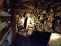
The Grey Cairns of Camster are two large Neolithic chambered cairns located about quarter of a mile north of Upper Camster. The cairns, which are considered to be examples of the Orkney-Cromarty type of chambered cairn, were constructed in the third or fourth millennium BC in a desolate stretch of boggy peat-covered moorland in the Flow Country of Caithness. [2]

Related Research Articles

<span class="mw-page-title-main">Chambered cairn</span> Burial monument (Usually Neolithic)

A chambered cairn is a burial monument, usually constructed during the Neolithic, consisting of a sizeable chamber around and over which a cairn of stones was constructed. Some chambered cairns are also passage-graves. They are found throughout Britain and Ireland, with the largest number in Scotland.

<span class="mw-page-title-main">Cairn</span> Human-made pile of stones or burial monument

A cairn is a human-made pile of stones raised for a purpose, usually as a marker or as a burial mound. The word cairn comes from the Scottish Gaelic: càrn.

<span class="mw-page-title-main">Caithness</span> Historic county in northern Scotland

Caithness is a historic county, registration county and lieutenancy area of Scotland.

<span class="mw-page-title-main">Court cairn</span> Type of chamber tomb found in Ireland and Scotland

The court cairn or court tomb is a megalithic type of chambered cairn or gallery grave. During the period, 3900–3500 BC, more than 390 court cairns were built in Ireland and over 100 in southwest Scotland. The Neolithic monuments are identified by an uncovered courtyard connected to one or more roofed and partitioned burial chambers. Many monuments were built in multiple phases in both Ireland and Scotland and later re-used in the Early Bronze Age.

<span class="mw-page-title-main">Clava cairn</span> Type of Bronze Age chamber tomb

The Clava cairn is a type of Bronze Age circular chamber tomb cairn, named after the group of three cairns at Balnuaran of Clava, to the east of Inverness in Scotland. There are about 50 cairns of this type in an area round about Inverness. They fall into two sub-types, one typically consisting of a corbelled passage grave with a single burial chamber linked to the entrance by a short passage and covered with a cairn of stones, with the entrances oriented south west towards midwinter sunset. In the other sub-type an annular ring cairn encloses an apparently unroofed area with no formal means of access from the outside. In both sub-types a stone circle surrounds the whole tomb and a kerb often runs around the cairn. The heights of the standing stones vary in height so that the tallest fringe the entrance and the shortest are directly opposite it.

<span class="mw-page-title-main">New Luce</span> Civil parish in south-west Scotland

New Luce is a civil parish in Dumfries and Galloway, south-west Scotland. It lies in the traditional county of Wigtownshire, and is about 10 miles (16 km) in length and 5 miles (8.0 km) in breath, being the upper part of the original Glenluce Parish. New Luce is shown as a civil parish on John Ainslie's county map of 1782.

<span class="mw-page-title-main">Ulbster</span> Human settlement in Scotland

Ulbster is a scattered crofting hamlet on the eastern coast of Caithness, within the parish of Wick, in the Scottish Highlands, within the Highland Council area. The town of Wick is located seven miles north of the village along the A99 road. To the south of the village, two miles along the A99, lies the ancient port of Whaligoe, where the famous 330 steps were cut into a cliff on the instruction of Thomas Telford in 1786.

<span class="mw-page-title-main">Achvarasdal</span> Human settlement in Scotland

Achvarasdal is a village in Caithness, Scotland, within the Highland council area.

<span class="mw-page-title-main">Parc Cwm long cairn</span> Burial chamber in Wales

Parc Cwm long cairn, also known as Parc le Breos burial chamber, is a partly restored Neolithic chambered tomb, identified in 1937 as a Severn-Cotswold type of chambered long barrow. The cromlech, a megalithic burial chamber, was built around 5850 years before present (BP), during the early Neolithic. It is about seven 12 miles (12 km) west south–west of Swansea, Wales, in what is now known as Coed y Parc Cwm at Parc le Breos, on the Gower Peninsula.

<span class="mw-page-title-main">Midhowe Chambered Cairn</span> Neolithic chambered cairn on Rousay, Orkney, Scotland

Midhowe Chambered Cairn is a large Neolithic chambered cairn located on the south shore of the island of Rousay, Orkney, Scotland. The name "Midhowe" comes from the Iron Age broch known as Midhowe Broch, that lies just west of the tomb. The broch got its name from the fact that it is the middle of three such structures that lie grouped within 500 metres (1,600 ft) of each other and Howe from the Old Norse word haugr meaning mound or barrow. Together, the broch and chambered cairn form part of a large complex of ancient structures on the shore of Eynhallow Sound separating Rousay from Mainland, Orkney.

<span class="mw-page-title-main">Unstan Chambered Cairn</span> Neolithic chambered cairn

Unstan is a Neolithic chambered cairn located about 2 mi (3 km) north-east of Stromness on Mainland, Orkney, Scotland. The tomb was built on a promontory that extends into the Loch of Stenness near the settlement of Howe. Unstan is notable as an atypical hybrid of the two main types of chambered cairn found in Orkney, and as the location of the first discovery of a type of pottery that now bears the name of the tomb. The site is in the care of Historic Environment Scotland as a scheduled monument.

Upper Lybster is a scattered and crofting village, situated 2 miles north of Lybster, in eastern Caithness, Scottish Highlands and is in the Scottish council area of Highland.

Roster is a remote scattered crofting township, in Caithness, Scottish Highlands and is in the Scottish council area of Highland.

<span class="mw-page-title-main">Grey Cairns of Camster</span> Chambered cairns in Scotland

The Grey Cairns of Camster are two large Neolithic chambered cairns located about 8+12 miles south of Watten and 5 miles (8 km) north of Lybster in Caithness, in the Highland region of Scotland. They are among the oldest structures in Scotland, dating to about 5,000 years ago. The cairns demonstrate the complexity of Neolithic architecture, with central burial chambers accessed through narrow passages from the outside. They were excavated and restored by Historic Environment Scotland in the late 20th century and are open to the public.

<span class="mw-page-title-main">British megalith architecture</span> Study of those ancient cultures that built megalithic sites on the British Isles

British megalith architecture is the study of those ancient cultures that built megalithic sites on the British Isles, including the research and documentation of these sites. The classification sometimes used of these cultures based on geological criteria is problematic.

<span class="mw-page-title-main">Tulach an t-Sionnaich</span> Cairn in Scotland

Tulach an t-Sionnaich, is a cairn at the northern end of Loch Calder in Caithness, Scotland that has been expanded over time. It was partially excavated in 1961 and 1963. Before the excavations there was just a 60-metre (200 ft) long and 12-metre (40 ft) wide cairn with no recognizable structures. The cairn is oriented from northwest to southeast; the southeastern end being higher and somewhat wider. Subsequently a ditch was cut some 15 metres (50 ft) from this end of the cairn.

<span class="mw-page-title-main">Heel-shaped cairn</span> Type of megalithic monument

The heel-shaped cairn, with its usually cruciform chamber, is a type of megalithic monument that is found in Scotland, especially in Caithness and Sutherland and in the Shetland Islands. In Orkney, the Isbister Cairn is the only site that is similar in shape.

<span class="mw-page-title-main">Carn Ban, Arran</span>

References

  1. Microsoft; Nokia (4 January 2018). "Upper Camster" (Map). Bing Maps . Microsoft. Retrieved 4 January 2018.
  2. "Grey Cairns of Camster". Historic Environment Scotland. Retrieved 4 January 2018.