
The West End of London is a district of Central London, London, England, west of the City of London and north of the River Thames, in which many of the city's major tourist attractions, shops, businesses, government buildings and entertainment venues, including West End theatres, are concentrated.

Mayfair is an area in London, England and is located in the City of Westminster. It is in Central London and part of the West End. It is between Oxford Street, Regent Street, Piccadilly and Park Lane and one of the most expensive districts in the world.

Pimlico is an area of Central London in the City of Westminster, built as a southern extension to neighbouring Belgravia. It is known for its garden squares and distinctive Regency architecture. Pimlico is demarcated to the north by Victoria Station, by the River Thames to the south, Vauxhall Bridge Road to the east and the former Grosvenor Canal to the west. At its heart is a grid of residential streets laid down by the planner Thomas Cubitt, beginning in 1825 and now protected as the Pimlico Conservation Area. The most prestigious are those on garden squares, with buildings decreasing in grandeur away from St George's Square, Warwick Square, Eccleston Square and the main thoroughfares of Belgrave Road and St. George's Drive. Additions have included the pre–World War II Dolphin Square and the Churchill Gardens and Lillington and Longmoore Gardens estates, now conservation areas in their own right. The area has over 350 Grade II listed buildings and several Grade II* listed churches. At the western edge of Pimlico, on the borders of Chelsea, Pimlico Road has become known in recent years for its interiors and design stores.

Park Lane is a dual carriageway road in the City of Westminster in Central London. It is part of the London Inner Ring Road and runs from Hyde Park Corner in the south to Marble Arch in the north. It separates Hyde Park to the west from Mayfair to the east. The road has a number of historically important properties and hotels and has been one of the most sought after streets in London, despite being a major traffic thoroughfare.

Belgravia is a district in Central London, covering parts of the areas of the City of Westminster and the Royal Borough of Kensington and Chelsea.

Berkeley Square is a garden square in the West End of London. It is one of the best known of the many squares in London, located in Mayfair in the City of Westminster. It was laid out in the mid 18th century by the architect William Kent, and originally extended further south. The garden's very large London Plane trees are among the oldest in central London, planted in 1789.

Grosvenor House was one of the largest townhouses in London, home of the Grosvenor family for more than a century. Their original London residence was on Millbank, but after the family had developed their Mayfair estates, they moved to Park Lane to build a house worthy of their wealth, status and influence in the 19th century. The house gave its name to Upper Grosvenor Street and Grosvenor Square.

Grosvenor Square is a large garden square in the Mayfair district of Westminster, Greater London. It is the centrepiece of the Mayfair property of the Duke of Westminster, and takes its name from the duke's surname "Grosvenor". It was developed for fashionable residences in the 18th century. In the 20th it had an American and Canadian diplomatic presence, and currently is mixed use, commercial.
Grosvenor Group Limited is an internationally diversified property group, which traces its origins to 1677 and has its headquarters in London, England. It has a global reach, now in 62 international cities, with offices in 14 of them, operated on behalf of its owners, the Duke of Westminster and his family. It has four regional development and investment businesses and a portfolio of indirect investments. Its sectors include residential, office, retail, industrial, along with hotels.

Robert Grosvenor, 1st Marquess of Westminster, was the son of the 1st Earl Grosvenor, whom he succeeded in 1802 as 2nd Earl Grosvenor. He was created Marquess of Westminster in 1831. He was an English Member of Parliament (MP) and an ancestor of the modern-day Dukes of Westminster. Grosvenor continued to develop the family's London estates, he rebuilt their country house, Eaton Hall in Cheshire where he also restored the gardens, and built a new London home, Grosvenor House. He maintained and extended the family interests in the acquisition of works of art, and in horse racing and breeding racehorses.

Brook Street is an axial street in the exclusive central London district of Mayfair. Most of it is leasehold, paying ground rent to and seeking lease renewals from the reversioner, that since before 1800, has been the Grosvenor Estate. Named after the Tyburn that it crossed, it was developed in the first half of the 18th century and runs from Hanover Square to Grosvenor Square. The western continuation is called Upper Brook Street; its west end faces Brook Street Gate of Hyde Park. Both sections consisted of neo-classical terraced houses, mostly built to individual designs. Some of them were very ornate, finely stuccoed and tall-ceilinged, designed by well known architects for wealthy tenants, especially near Grosvenor Square, others exposed good quality brickwork or bore fewer expensive window openings and embellishments. Some of both types survive. Others have been replaced by buildings from later periods.
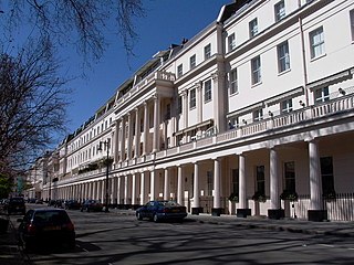
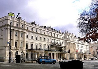
Eaton Square is a rectangular, residential garden square in London's Belgravia district. It is the largest square in London. It is one of the three squares built by the landowning Grosvenor family when they developed the main part of Belgravia in the 19th century that are named after places in Cheshire — in this case Eaton Hall, the Grosvenor country house. It is larger but less grand than the central feature of the district, Belgrave Square, and both larger and grander than Chester Square. The first block was laid out by Thomas Cubitt from 1827. In 2016 it was named as the "Most Expensive Place to Buy Property in Britain", with a full terraced house costing on average £17 million — many of such town houses have been converted, within the same, protected structures, into upmarket apartments.

Long Acre is a street in the City of Westminster in central London. It runs from St Martin's Lane, at its western end, to Drury Lane in the east. The street was completed in the early 17th century and was once known for its coach-makers, and later for its car dealers.

Grosvenor Canal was a canal in the Pimlico area of London, opened in 1824. It was progressively shortened, as first the railways to Victoria Station and then the Ebury Bridge housing estate were built over it. It remained in use until 1995, enabling barges to be loaded with refuse for removal from the city, making it the last canal in London to operate commercially. A small part of it remains within the Grosvenor Waterside development.

Victoria Square is a small, rectangular garden square in Westminster, Greater London, beginning some 50 metres south of the remaining stables of the Royal Mews and 150 metres north of Victoria bus station, which stands in front of Victoria Station. It has a statue of the young Queen Victoria.

St George Hanover Square was a civil parish in the metropolitan area of London, England. The creation of the parish accompanied the building of the Church of St George's, Hanover Square, constructed by the Commission for Building Fifty New Churches to meet the demands of the growing population. The parish was formed in 1724 from part of the ancient parish of St Martin in the Fields in the Liberty of Westminster and county of Middlesex. It included some of the most fashionable areas of the West End, including Belgravia and Mayfair. Civil parish administration, known as a select vestry, was dominated by members of the British nobility until the parish adopted the Vestries Act 1831. The vestry was reformed again in 1855 by the Metropolis Management Act. In 1889 the parish became part of the County of London and the vestry was abolished in 1900, replaced by Westminster City Council. The parish continued to have nominal existence until 1922. As created, it was a parish for both church and civil purposes, but the boundaries of the ecclesiastical parish were adjusted in 1830, 1835 and 1865.

St George's Square is a prestigious and very long garden square in affluent Pimlico, Central London. It benefits from gardens and a church in its central area. Near the northern acute angle, the square is intersected by Lupus Street. Pimlico tube station is a short distance east. Its north-east side is in effect Belgrave Road and southern side is arterial Grosvenor Road which is lined by a small public garden in front of the River Thames.
Somerset House, was an 18th-century town house on the east side of Park Lane, where it meets Oxford Street, in the Mayfair area of London. It was also known as 40 Park Lane, although a renumbering means that the site is now called 140 Park Lane.

In British usage, the term townhouse originally referred to the opulent town or city residence of a member of the nobility or gentry, as opposed to their country seat, generally known as a country house or, colloquially, for the larger ones, stately home. The grandest of the London townhouses were stand-alone buildings, but many were terraced buildings.

South Audley Street is a major shopping street in Mayfair, London. It runs north to south from the southwest corner of Grosvenor Square to Curzon Street.

