Caldecote is a tiny hamlet in the civil parish of Moulsoe in the City of Milton Keynes, Buckinghamshire, England, situated roughly 1 mile (1.6 km) south of Newport Pagnell, and roughly 3 miles (4.8 km) north-east of Central Milton Keynes.
Boycott is a hamlet in the parish of Stowe in north Buckinghamshire, England.

Bletchley is a constituent town of Milton Keynes, Buckinghamshire, England. It is situated in the south-west of Milton Keynes, and is split between the civil parishes of Bletchley and Fenny Stratford and West Bletchley.

Calverton is a civil parish in the unitary authority area of the City of Milton Keynes, Buckinghamshire, England and just outside the Milton Keynes urban area, situated roughly 1 mile (1.6 km) south of Stony Stratford, and 4 miles (6.4 km) west of Central Milton Keynes. The parish consists of one village, Lower Weald and two hamlets: Upper Weald and Middle Weald. Lower Weald is the largest of the three settlements, and Manor Farm, the parish church and the former parochial school are within its boundaries.

Filgrave is a hamlet in the unitary authority area of the City of Milton Keynes, Buckinghamshire, England. It is about 3 miles (4.8 km) north of Newport Pagnell and 6 miles (9.7 km) north-east of Central Milton Keynes.
Long Street is a hamlet in the parish of Hanslope, in the unitary authority area of the City of Milton Keynes, ceremonial Buckinghamshire, England. It is located on the road that leads from Hanslope to Northampton. The hamlet is named for the road on which the hamlet is located.
Upton is a hamlet in the civil parish of Dinton-with-Ford and Upton, in Buckinghamshire, England. It is located to the north of the main village of Dinton, on the junction between the new road from Aylesbury to Thame, and the old road before it was rerouted.
Canons Ashby is a small village and civil parish in West Northamptonshire, England. The population of the village is included in the civil parish of Preston Capes.

Little Everdon is a small hamlet in the civil parish of Everdon in the county of Northamptonshire, England. Lying on the Nene Way long-distance footpath, its parkland, large stone houses and manor house are typical of English countryside.
White Hills is a residential district of the town of Northampton, England. It is at the northern limits of the town, north of Kingsthorpe and between the A508 and A5199 roads. The population is included in the Spring Park ward of Northampton.

Pipe and Lyde is a village and civil parish in Herefordshire, England. The parish includes the village of Pipe and Lyde and the hamlets of Lower Lyde and Upper Lyde. The population of the civil parish as taken at the 2011 census was 344. Parts of the church of St Peter date from the 13th century including the south doorway which includes Transitional moulding. James Honeyman-Scott (1956-1982), the Pretenders guitarist, is buried in the churchyard.

This history of Milton Keynes details its development from the earliest human settlements, through the plans for a 'new city' for 250,000 people in northern Southeast England, its subsequent urban design and development, to the present day. Milton Keynes is the largest settlement and only city in Buckinghamshire, founded in 1967. At the 2021 census, the population of its urban area was estimated to have exceeded 256,000.
Lenton, Keisby and Osgodby is a civil parish in South Kesteven, Lincolnshire, England. The population of the civil parish at the 2011 census was 187. It is located along the river and in the valleys of the East Glen at its headwaters near Ingoldsby, where several minor streams join together.

The Grafton Way is a 13-mile (21 km) footpath in Northamptonshire, England. It runs south east from Greens Norton to Cosgrove, where it meets the Knightley Way. It is named after the Dukes of Grafton, major land-owners in the area in the 18th and 19th centuries.
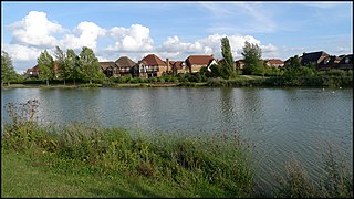
Whitehouse is a district and civil parish that covers a large new development area on the western flank of Milton Keynes, Buckinghamshire, England. As the first tier of Local Government, its community council is responsible for the people, living and working in this area of Milton Keynes.