Utica Parks and Parkway Historic District

Last updated

Utica Parks and Parkway Historic District
Bathhouse Arch.JPG
Bathhouse archway in the district
USA New York location map.svg
Red pog.svg
Usa edcp location map.svg
Red pog.svg
LocationParkway and Pleasant St, Utica, New York
Coordinates 43°4′47.16″N75°13′56.07″W / 43.0797667°N 75.2322417°W / 43.0797667; -75.2322417
Area625 acres (253 ha)
Built1909
Architect Frederick Law Olmsted Jr., Edward C. Whiting
NRHP reference No. 08000594 [1]
Added to NRHPJuly 03, 2008

Utica Parks and Parkway Historic District is a national historic district located at Utica in Oneida County, New York, United States. It consists of four contributing historic elements: a historic right-of-way known as the Memorial Parkway and the three large parks it connects: Roscoe Conkling Park, F.T. Proctor Park, and T.R. Proctor Park. The district includes seven contributing buildings, three contributing sites, 26 contributing structures, and five contributing objects. The park and parkway system was designed between 1908 and 1914 by the firm of Olmsted Brothers Landscape Associates, headed by Frederick Law Olmsted Jr. [2] The Utica Zoo is located in Roscoe Conkling Park.

Contents

It was listed on the National Register of Historic Places in 2009. [1]

History

Thomas Redfield Proctor (May 25, 1844 - July 4, 1920) was a prominent Utica businessman and philanthropist. Thomas R. Proctor High School is also named for him. Proctor purchased about 400 acres (160 ha) of farmland in 1904 and contracted the Olmstead brothers to design a city parks system. Thomas R. Proctor Park and Roscoe Conkling Park opened to the public in 1909. Proctor had also gifted the smaller Watson-Williams Park to the city in 1897, and Horatio Seymour, Addison C. Miller, Truman K. Butler, and J. Thomas Spriggs Parks in 1908. [3] [4] [5]

Frederick T. Proctor Park

Frederick T. Proctor Park is located on the corner of Rutger Street and Culver Avenue. It is considered the “Crown Jewel” of the district's parks as it is the smallest of the three, containing 62 acres (25 ha) of land. [6] The Works Progress Administration contributed in building some of the parks' structures; [4] these structures were not part of the original park plan, but still hold historical significance. [7] The park includes a lily pond, a butterfly garden, bathhouses and stonework. Many of the trees and flowers in the park were planted by volunteers. [8] The Starch Factory Creek, which is known for its landscape and its woods, flows through T. R. Proctor Park and F. T. Proctor Park. [7] The park hosts the city's Fourth of July fireworks. [9]

Thomas R. Proctor Park

100 acres (40 ha) Thomas R. Proctor Park is south of F. T. Proctor Park on the corner of Culver Avenue and Welshbush Road. It has 100 acres (40 ha) of land with baseball and soccer fields, basketball courts, a playground and running trail. [10]

Roscoe Conkling Park

Roscoe Conkling Park is located along Oneida Street and the Memorial Parkway totaling up to 625 acres (253 ha). This was the first park developed by the Proctor brothers in 1909. It was designed to give Utica a pastoral appearance. The park includes the Utica Zoo, Valley View Golf Course, Val Bialas Ski and Sled Chalet, Parkway Recreation Center, John Mott Tennis Courts, South Woods switchback trails and several monuments. Roscoe Conkling Park also has many memorials and statues, including the Eagle Monument. [10]

The Utica Zoo is situated on the park's grounds and features over 200 animals on forty acres of land. The Park also includes the Valley View Golf Course, which was designed by Robert Trent Jones. [11]

During the winter, visitors can visit the Val Bialas Ski and Sled Chalet, named for local Olympian ice skater Valentine Bialas. It offers a rope tow, chair lift, night skiing, an ice rink and chalet with a snack bar. [10] During the winter The South Woods Switchback Trails are groomed for cross country skiing.

The Parkway Recreation Center, also known as the Edward A. Hanna Recreation Center, contains two modified basketball courts, a playground, weight training station, exercise equipment, walking track, tennis courts, computer room, conference area, and the Utica Sport Hall of Fame. The Recreation Center also accommodates the Utica Boys & Girls Club and the Parkway Senior Center. [12]

Memorial Parkway

The Memorial Parkway is a divided parkway with a wide grassy median for most of its length. East of Mohawk Valley Community College the two sides join, and east of the Utica Armory it becomes Culver Avenue. From west to east, the monuments on the Memorial Parkway are: [13] [14] [15]

Caption
OrderNameErectedLocationNotes
1 James Schoolcraft Sherman 1923West of Genesee Street, facing eastUtica native Sherman served as US Vice President under William Howard Taft.
2Major General Friedrich Wilhelm von Steuben 1914East of Genesee Street, facing westGeneral in the US Revolutionary War, settled in Remsen, New York after the war. Erected by the Utica German American Alliance. [16]
3 Vietnam War memorial1985West of Holland Avenue
4George E. Dunham1931East of Holland AvenueEditor of the Utica Daily Press, vice principal of the Whitestown Seminary, manager of the Utica State Hospital for the Insane
5Brigadier General Casimir Pulaski 1930West of Oneida StreetGeneral in the US Revolutionary War
6 Spanish American War/USS Maine Memorial1915East of Oneida Street
7 POW/MIA Memorial1992Across from the Parkway Center
8Central New York War Memorial2000Across from Kemble StreetMemorial for World War I, World War II, and the Korean War.
9Mary S. Hendricks Police and Firefighters Memorial Park2005Across from Kemble StreetNamed for a Utica woman who advocated for the Utica Police and Fire departments.
10Statue of Liberty1950West of Elm StreetA replica of the Statue of Liberty in New York City. One of nearly 200 copies gifted by the Boy Scouts of America on their 40th anniversary. [17]
11Swan Memorial Fountain1910East of Elm StreetDedicated to Joseph R. Swan, a prominent Utica lawyer, by his wife. Sculpted by Frederick MacMonnies. [18]
12Thomas R. Proctor1921East of previousMemorial to Thomas R. Proctor, for whom Thomas R. Proctor Park is also named.
13 Christopher Columbus 1952, moved to current location 1966West of Mohawk StreetGift of the Federation of Italian-American Societies of Utica. Originally stood outside the Utica Observer-Dispatch.
14 September 11 Memorial 2011East of Sherman Place

Related Research Articles

<span class="mw-page-title-main">Central Park</span> Public park in Manhattan, New York

Central Park is an urban park between the Upper West Side and Upper East Side neighborhoods of Manhattan in New York City that was the first landscaped park in the United States. It is the sixth-largest park in the city, containing 843 acres (341 ha), and the most visited urban park in the United States, with an estimated 42 million visitors annually as of 2016.

<span class="mw-page-title-main">Utica, New York</span> City located in central New York, United States

Utica is a city in the Mohawk Valley and the county seat of Oneida County, New York, United States. The tenth-most-populous city in New York State, its population was 65,283 in the 2020 U.S. Census. Located on the Mohawk River at the foot of the Adirondack Mountains, it is approximately 95 mi (153 km) west-northwest of Albany, 55 mi (89 km) east of Syracuse and 240 mi (386 km) northwest of New York City. Utica and the nearby city of Rome anchor the Utica–Rome Metropolitan Statistical Area comprising all of Oneida and Herkimer Counties.

<span class="mw-page-title-main">Riverside Park (Manhattan)</span> Public park in New York City

Riverside Park is a scenic waterfront public park in the Upper West Side, Morningside Heights, and Hamilton Heights neighborhoods of the borough of Manhattan in New York City. The park measures 4 miles (6.4 km) long and 100 to 500 feet wide, running between the Hudson River and Henry Hudson Parkway to the west and the serpentine Riverside Drive to the east.

<span class="mw-page-title-main">Verona Beach State Park</span> State park in Oneida County, New York, USA

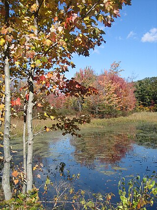
Verona Beach State Park is a 1,735-acre (7.02 km2) state park located on the eastern shore of Oneida Lake in the Town of Verona, Oneida County, New York. The park is located on NY 13 northwest of the City of Oneida and south of Sylvan Beach. Oneida Creek enters the Oneida Lake south of the park.

<span class="mw-page-title-main">Grant Park, Atlanta</span> Historic city park and neighborhood of Atlanta, Georgia, United States

Grant Park refers to the oldest city park in Atlanta, Georgia, United States, as well as the Victorian neighborhood surrounding it.

<span class="mw-page-title-main">Emerald Necklace</span> Chain of parks in Boston, Massachusetts

The Emerald Necklace consists of a 1,100-acre chain of parks linked by parkways and waterways in Boston and Brookline, Massachusetts. It was designed by landscape architect Frederick Law Olmsted, and gets its name from the way the planned chain appears to hang from the "neck" of the Boston peninsula. In 1989, the Emerald Necklace was designated as a Boston Landmark by the Boston Landmarks Commission.

<span class="mw-page-title-main">Druid Hills Historic District (Atlanta, Georgia)</span> Historic district in Georgia, United States

Druid Hills Historic District is a historic district in Druid Hills and Atlanta in DeKalb County, Georgia, United States, that is listed on the National Register of Historic Places (NRHP).

The Utica Children's Museum is a children's museum in Utica, New York. It closed its old downtown location in 2020 at the start of the COVID-19 pandemic. Its new location along Utica's Memorial Parkway is expected to open in 2024.

<span class="mw-page-title-main">Delaware Park–Front Park System</span> United States historic place

Delaware Park–Front Park System is a historic park system and national historic district in the northern and western sections of Buffalo in Erie County, New York. The park system was designed by Frederick Law Olmsted and Calvert Vaux and developed between 1868 and 1876.

<span class="mw-page-title-main">Golden Gate National Recreation Area</span> U.S. National Recreation Area surrounding San Francisco Bay Area

The Golden Gate National Recreation Area (GGNRA) is a U.S. National Recreation Area protecting 82,116 acres (33,231 ha) of ecologically and historically significant landscapes surrounding the San Francisco Bay Area. Much of the park is land formerly used by the United States Army. GGNRA is managed by the National Park Service and is the second-most visited unit of the National Park system in the United States, with more than 15.6 million visitors in 2022. It is also one of the largest urban parks in the world, with a size two-and-a-half times that of the consolidated city and county of San Francisco.

<span class="mw-page-title-main">Parks and recreation in Buffalo, New York</span>

Many of the public parks and parkways system of Buffalo, New York, were originally designed by Frederick Law Olmsted and Calvert Vaux between 1868 and 1896. They were inspired in large part by the parkland, boulevards, and squares of Paris, France. They include the parks, parkways and circles within the Cazenovia Park–South Park System and Delaware Park–Front Park System, both listed on the National Register of Historic Places and maintained by the Buffalo Olmsted Parks Conservancy.

<span class="mw-page-title-main">Charles River Reservation</span>

The Charles River Reservation is a 17-mile-long (27 km) urban preserve and public recreation area located along the banks of the Charles River in Boston, Cambridge, Watertown, and Newton, Massachusetts. The reservation is managed by the Massachusetts Department of Conservation and Recreation.

<span class="mw-page-title-main">Forest Hill Cemetery (Utica, New York)</span> Cemetery in Utica, New York, USA

Forest Hill Cemetery is a rural cemetery in Utica, New York founded in 1850. The cemetery was listed on the National Register of Historic Places in 2017. Forest Hills Cemetery is located at 2201 Oneida Street, in Utica, New York. It is a non-sectarian cemetery, which means anyone of any religion can be buried there. Over the years some nationally and locally recognized people have been buried here. Because of its many monuments, grave sites of famous people, along with other historical structures, the cemetery is sometimes referred to as "Utica's outdoor museum".

<span class="mw-page-title-main">Roscoe Conkling House</span> Historic house in New York, United States

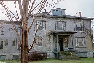
The Roscoe Conkling House is a historic house at 3 Rutger Park in Utica, New York, United States. A National Historic Landmark, it was the home of Roscoe Conkling (1829–1888), a powerful and controversial politician. He is responsible, perhaps, for the angry, political atmosphere that led to the assassination of U.S. President James Garfield.

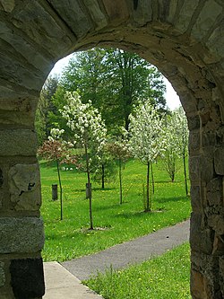
Rutger–Steuben Park Historic District is a 25-acre (10 ha) historic district in the city of Utica in Oneida County, New York. The district includes 63 contributing buildings and contains numerous examples of late nineteenth century Italian Villa style residences. A group of five exceptional dwellings are grouped together in a private park, known as Rutger Park, at the center of the district. One of the dwellings on Rutger Park was designed by architect Alexander Jackson Davis. The Roscoe Conkling House is located at 3 Rutger Park and it was declared a National Historic Landmark in 1975.

<span class="mw-page-title-main">Moses H. Cone Memorial Park</span> Park in North Carolina, United States

The Moses H. Cone Memorial Park is a country estate in honor of Moses H. Cone in Blowing Rock, North Carolina. It is on the Blue Ridge Parkway between mileposts 292 and 295 with access at milepost 294. Most locals call it Cone Park. The park is run by the National Park Service and is open to the public. It contains 3,500 acres (14 km2), a 16-acre (65,000 m2) trout lake, a 22-acre (89,000 m2) Bass Lake and 25 miles (40 km) of carriage trails for hiking and horses. The main feature of the park is a twenty-three room 13,000-square-foot (1,200 m2) mansion called Flat Top Manor built around the early 1900s. At the manor, there is a craft shop and demonstration center, along with an information desk and book store.

<span class="mw-page-title-main">Riverside Park (Buffalo, New York)</span> United States historic place

Riverside Park is a historic park located in the Riverside neighborhood in Buffalo, New York. Located in northwest Buffalo, it is an individual park designed by the Olmsted Architectural Firm in 1898 after Frederick Law Olmsted's retirement. It is on a 22-acre (8.9 ha) site on a bluff overlooking the Niagara River. Riverside Park was designed for active recreation and periodic alterations have occurred as the community's recreation needs have changed. Despite the changes, the park retains numerous original design elements and remains as the final element completed as a part of the Olmsted plan for Buffalo's park system.

<span class="mw-page-title-main">Baldwin Hills (mountain range)</span> Mountain range in Los Angeles County, California, United States

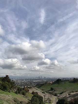
The Baldwin Hills are a low mountain range surrounded by and rising above the Los Angeles Basin plain in central Los Angeles County, California. The Pacific Ocean is to the west, the Santa Monica Mountains to the north, Downtown Los Angeles to the northeast, and the Palos Verdes Hills to the south—with all easily viewed from the Baldwin Hills.

<span class="mw-page-title-main">Martin Luther King Jr. Park</span> United States historic place

Martin Luther King Jr. Park, originally The Parade and after 1896, Humboldt Park, is a historic park located in Buffalo in Erie County, New York. The park is located in east Buffalo and bisected by Fillmore Avenue.

Cazenovia Park–South Park System is a historic park system located in the South Buffalo neighborhood at Buffalo in Erie County, New York. The interconnected set of parkways and parks was designed by Frederick Law Olmsted as part of his parks plan for the city of Buffalo, as inspired in large part by the parkland, boulevards, and squares of Paris, France.

References

  1. 1 2 "National Register Information System  (#08000594)". National Register of Historic Places . National Park Service. March 13, 2009.
  2. Raymond W. Smith (March 2008). "National Register of Historic Places Registration: Utica Parks and Parkway Historic District". New York State Office of Parks, Recreation and Historic Preservation. Archived from the original on October 5, 2012. Retrieved January 10, 2010.See also: "Accompanying eight photos". Archived from the original on October 5, 2012. Retrieved January 13, 2010.
  3. "Proctor". Oneida County History Center. Retrieved May 14, 2023.
  4. 1 2 Clarke, T. Wood. Utica for a Century And A Half. Utica: Earl Widtman, 1952. Print.
  5. Dyar, Marcie (August 30, 2022). "Proctor-Olmsted Day". Oneida County Tourism. Retrieved May 14, 2023.
  6. Staff, Renee Gamela. "'It's a jewel': Utica parks system marks 100 years." Observer-Dispatch (Utica, NY) 9 Sep. 2006, 1, A-Section: 1A. NewsBank. Web. 9 Dec. 2015.
  7. 1 2 "F.T. Proctor Park". Central New York Conservancy. Archived from the original on April 9, 2023. Retrieved April 19, 2023.
  8. "Lily Pond work to help restore grandeur to historic F.T. Proctor Park". Daily Sentinel. March 16, 2023. Retrieved May 14, 2023.
  9. Schneider, H. Rose. "Things to do, what to know for Independence Day around Utica". Utica Observer Dispatch. Archived from the original on April 20, 2023. Retrieved April 19, 2023.
  10. 1 2 3 "Parks & Open Spaces". City of Utica. Archived from the original on February 2, 2023. Retrieved April 19, 2023.
  11. "Valley View". City of Utica. Archived from the original on February 2, 2023. Retrieved April 19, 2023.
  12. "Recreation Center". City of Utica. Retrieved May 14, 2023.
  13. Madison, Samantha. "14 monuments you'll see on Memorial Parkway". Utica Observer-Dispatch. Retrieved June 28, 2020.
  14. "Memorial Parkway". Central New York Conservancy. Archived from the original on June 28, 2020. Retrieved June 28, 2020.
  15. "History of the Utica Parks". Central New York Conservancy. Archived from the original on June 29, 2020. Retrieved June 28, 2020.
  16. Pohlsander, Hans A. (2010). German Monuments in the Americas: Bonds Across the Atlantic. Peter Lang. pp. 28–29. ISBN   978-3034301381 . Retrieved February 21, 2018.
  17. "Statue of Liberty Replica, (sculpture), NY000432". Smithsonian Art Inventories Catalog. Archived from the original on June 28, 2020. Retrieved June 28, 2020.
  18. "Swan Memorial Fountain, (sculpture), NY000508". Smithsonian Art Inventories Catalog. Archived from the original on June 30, 2020. Retrieved June 28, 2020.