Kothamangalam,, is a municipality in the Ernakulam district of Kerala, India. The town is in the foothills of the Western Ghats, and is a part of the Idukki Lok Sabha constituency.

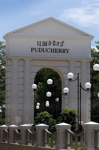
Pondicherry, now known as Puducherry, is the capital and most populous city of the Union Territory of Puducherry in India. The city is in the Puducherry district on the southeast coast of India and is surrounded by the Bay of Bengal to the east and the state of Tamil Nadu, with which it shares most of its culture, heritage, and language.

Cuddalore District is one of the 38 districts in the state of Tamil Nadu in India.

Perambalur is a town in the Indian state of Tamil Nadu. It is the headquarters of Perambalur district and Perambalur taluk (sub-district). As of 2011 census, the town had a population of 49,648.
Kanakapura is a city in the Ramanagara district of Karnataka on the banks of the Arkavathi river and the administrative center of the taluk of the same name. Kanakapura is largest cocoon silk producer in India. River Cauvery flows around 21 km in Kanakapura Taluk.Previously belonged to Bangalore Rural District. It was formerly the largest constituency in the country. (1,553 km2 [600 sq mi]). It is located among the lush green forests of the state of Karnataka. The town is a tourism hotspot and an often visited tourist favorite in the entire state of Karnataka, as it has something for everyone ranging from avid trekkers to history buffs and wildlife enthusiasts. The forest area in this taluk is very wide and about half of the Bannerghatta National Park is located in our Kanakapura area. Kodihalli wildlife range and harohalli wildlife range its division. The Kaveri Wildlife Sanctuary consists of two main zones namely the Sangam Wildlife range, the Muggur Wildlife range
Chengam is an important market town and a taluk headquarter in the Foot hills of Eastern ghats in Tiruvannamalai district of Tamil Nadu, India. Chengam is the gateway to the Chengam pass in the Eastern ghats between Javvadhu hills to the north and Chennakesava hills to the south. The town is also the center for various industrial activities which includes Sathanur dam hydro-electric project, Aavin milk processing plant and Periya Kolappadi SIDCO estate.
Choornikkara is a census town and in Aluva in Ernakulam District in Kerala, India. It is also the headquarters of the Choornikkara gram panchayat
Gangavati is a city, municipality and taluk in the Koppal district of the Indian state of Karnataka. It is one of the main commercial hubs in the Kalyana-Karnataka region. It is also the largest city, in terms of area and population, in the Koppal district.

Hosakote is a taluk or city in Bangalore Rural District, India. Headquartered at the Hosakote town, it consists of five hoblis - Kasaba, Anugondanahalli, Jadigenahalli, Nandagudi and Sulibele. There are 294 villages in Hoskote taluk including the 5 hoblis. Also famous for Dum Biriyani's which is unique in taste.
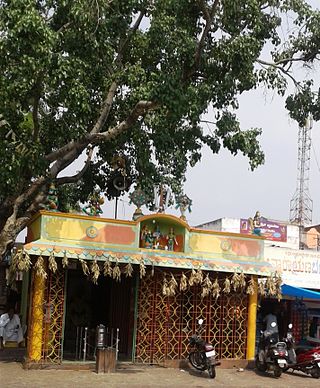
Kilpennathur is a Panchayat Town in Tiruvanamalai district in the Indian state of Tamil Nadu. Kilpennathur is one of the taluks of Tiruvannamalai district and an assembly constituency of Tamil Nadu. The MLA of Kilpennathur assembly constituency is DMK party Mr. K. Pichandi. Vettavalam is the most populous town panchayat in this taluk. Kilpennathur is located a 12.25 degrees latitude and 79.224 degrees longitude. Nearest towns are Avalurpet, Vettavalam, Gingee and Tiruvannamalai, and Chennai is about 177 km away.
Musiri is a municipality in the Tiruchirappalli district in the Indian state of Tamil Nadu. It has an average elevation of 82 metres (269 feet).
Panniyannur is a census town in Thalassery taluk of Kannur district in the Indian state of Kerala. It is part of Greater Mahé Region.

Ramanattukara is a municipality census town in Kozhikode district in the Indian state of Kerala. This town was formerly called Kadungan Chira village. Ramanattukara is located 15 km away from Kozhikode city.

Channarayapatna is a town and Taluk headquarters in Hassan district of Karnataka, India. It lies on the Bangalore-Mangalore National Highway-75 in Karnataka, India.It has number of temples like Chandramouleshwara Temple(standing Shiva), Channakeshava temple, Anjaneya temple, Tejigereyamma temple... etc. Famous Jain pilgrimage Shravanabelagola belongs to this taluk. Channarayapatna has major railway connection from Bengaluru to Mangaluru, Karwar and also Mysuru.

Viluppuram, Villupuram or Vizhuppuram is one of the 38 districts that make up the state of Tamil Nadu, India. It was founded on 30 September 1993, prior to which it was part of the Cuddalore district. Vizhuppuram district lies in the way of the national highway connecting Tiruchirappalli and Chennai, and contains historical landmarks like the 500 year-old Gingee Fort.
The Puducherry district, also known by its former name Pondicherry district, is one of the four districts of the union territory of Puducherry in South India. The district occupies an area of 290 square kilometres (110 sq mi), spread over 12 non-contiguous enclaves lying on or near the Bay of Bengal within a compact area in the state of Tamil Nadu. According to the 2011 census, the district has a population of 950,289.

Thiruvarur district is one of the 38 districts in the Tamil Nadu state of India. As of 2011, the district had a population of 1,264,277 with a sex-ratio of 1,017 females for every 1,000 males.
Adirampattinam is a newly established Municipality in the Pattukottai taluk of the Thanjavur district in the Indian state of Tamil Nadu. It is also short known by Adirai. It is the largest coastal town in the district and fourth largest town in the Thanjavur district.
Uzhavarkarai or Ozhukarai taluk is one of four taluks in the Pondicherry District of the union territory of Puducherry. Uzhavarkarai taluk has only one sub-taluk/firka, viz. Uzhavarkarai. It consists of 8 revenue villages.
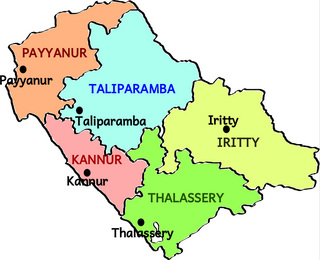
Taliparamba taluk is one of the five taluks in Kannur district in the state of Kerala, India. It borders Payyanur Taluk in the north, Kannur taluk and Thalassery taluk in the south and Iritty taluk in the east. It is a revenue division for the ease of administrative purposes, and is headquartered in Taliparamba. Most government offices are in the Mini Civil Station in Taliparamba. Taliparamba taluk consists of Taliparamba Municipality, Anthoor Municipality, Sreekandapuram Municipality and 15 surrounding panchayats.

