Rocha House is a historic site in Los Angeles, California, that was designated Los Angeles Historic-Cultural Monument #13 in 1963. It is located in Reynier Village in Mid-City, Los Angeles.
Los Gatos Creek formerly known as Arroyo Pasajero or Arroyo Poso de Chane, is a creek in Fresno County, California. Its source is in the north end of Garcia Canyon in the Diablo Range near Benito Pass. From there it runs through Los Gatos Canyon, in the eastern foothills of the Diablo Range, then passes across Pleasant Valley, north of Coalinga, where Warthan Creek joins it east of the town. Then it flows eastward to its confluence with Jacalitos Creek, before it passes to the north of the Guijarral Hills, into the San Joaquin Valley, where it is joined by Zapato Chino Creek.
Rancho de los Californios is a former settlement in Fresno County, California. It was named after the Californios.
Asphalto is a former settlement in Kern County, California. It was located on the railroad 3 miles (4.8 km) northeast of McKittrick, at an elevation of 932 feet. Asphalto still appeared on maps as of 1932.

Rancho Las Positas was a 8,880-acre (35.9 km2) Mexican land grant in present-day Alameda County, California given in 1839 by governor Juan Alvarado to Robert Livermore and José Noriega. Las Positas means "little watering holes" in Spanish. The rancho included the present-day city of Livermore.
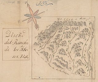
Rancho Cañada de los Alisos was a 10,668-acre (43.17 km2) Mexican land grant in present-day Orange County, California given by Governor Juan Bautista Alvarado to Jose Antonio Fernando Serrano in 1842, and enlarged by a second grant by Pio Pico in 1846. The name means "Glen of the Alders" in Spanish, after the native White Alder (Alnus rhombifolia) trees growing there. The rancho included the present day cities of Lake Forest, and the Marine Corps Air Station El Toro—Orange County Great Park site in Irvine.
Rancho Los Putos also called Rancho Lihuaytos was a 44,384-acre (179.62 km2) Mexican land grant in present-day Solano County, California given in 1843 by Governor Manuel Micheltorena to Juan Felipe Peña and Juan Manuel Vaca.
Rancho San Miguel was a 4,694-acre (19.00 km2) Mexican land grant in present-day Ventura County, California given in 1841 by Governor Juan Bautista Alvarado to Felipe Lorenzana and Raymundo Olivas. The grant encompassed the area of present-day City of Ventura not within Rancho Ex-Mission San Buenaventura, with the Santa Clara River marking its southern boundary.
Rancho La Goleta was a 4,426-acre (17.91 km2) Mexican land grant in present-day Santa Barbara County, California given in 1846 by Governor Pío Pico to Daniel A. Hill. The grant extended along the Pacific coast from today’s Fairview Avenue in present-day Goleta, east to Hope Ranch. The grant was adjacent to Rancho Dos Pueblos granted to his son-in-law Nicolas A. Den in 1842.
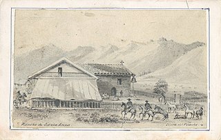
Rancho Santa Ana was a 21,522-acre (87.10 km2) Mexican land grant in present day Ventura County, California given in 1837 by Governor Juan Alvarado to Crisogono Ayala and Cosme Vanegas. Rancho Santa Ana was located inland in the Ventura River Valley on the west side of the Ventura River across from Rancho Ojai which was granted in the same year. Rancho Santa Ana encompassed present day Lake Casitas and Oak View.
El Camino Viejo a Los Ángeles, also known as El Camino Viejo and the Old Los Angeles Trail, was the oldest north-south trail in the interior of Spanish colonial Las Californias (1769–1822) and Mexican Alta California (1822–1848), present day California. It became a well established inland route, and an alternative to the coastal El Camino Real trail used since the 1770s in the period.
La Libertad, California is a former settlement in Fresno County, California that was 1/2 mile south and 5 miles east of Burrel, California. It was an early Mexican settlement in San Joaquin Valley, on the eastern route of El Camino Viejo that existed there at least until 1870.
Poso de Chane or Poso Chane is a former settlement in Fresno County, California situated around the waterhole of that name, northwest just below the confluence of the Jacalitos Creek with Los Gatos Creek, 6 miles (9.7 km) east of Coalinga and northwest of the Guijarral Hills.
Jacalitos Creek formerly known as Arroyo de Jacelitos, is a creek in Fresno County, California.
Canoas Creek formerly known as Arroyo de Las Canoas is a creek in Fresno County, California. Its source is on the north slope of Black Mountain, 1.25 miles west of Zwang Peak in the Diablo Range. Its course, in its canyon, runs almost directly northeast through Reef Ridge and the Kreyenhagen Hills, from which it flows north northeast into the Kettleman Plain where it turns north northwest 4.6 miles northwest of Avenal near the Kettleman Hills to terminate in the Kettleman Plain, 7.1 miles northwest of Avenal and 3000 feet east of Zapato Chino Creek.
Cox & Clark Trading Post was an adobe building on the west shore of Tulare Lake. It was at that time the only building on that side of the lake and was located on the lakeshore 3 miles (4.8 km) southwest of the modern Kettleman City.
Widow Smith's Station, also known as Major Gordon's Station and Clayton's Station, was a stagecoach station of the Butterfield Overland Mail 1st Division from 1858 to 1861 in southern California.
Lone Willow Station was a former settlement in Merced County, California, located near present-day Los Banos.
There are multiple prehistoric petroglyphs in the area of Bishop, California that may be called the Bishop Petroglyphs.
The Pioneer Cemetery, formerly known as the North Branch Cemetery, is a defunct cemetery established in c. 1851, and located along California State Route 12 in San Andreas, Calaveras County, California. It is the oldest known cemetery in Calaveras County.