
Kottayam is one of fourteen districts in the state of Kerala, India. Kottayam district comprises six municipal towns: Kottayam, Changanassery, Pala, Erattupetta, Ettumanoor, and Vaikom. It is the only district in Kerala that neither border the Arabian Sea nor any other states.

Pathanamthitta District is a district in the southern part of Kerala, India. The district headquarters is in the town of Pathanamthitta. There are four municipalities in Pathanamthitta: Tiruvalla, Adoor, Pathanamthitta and Pandalam.

Mainpuri district is one of the districts in the Agra division of Uttar Pradesh, India. Mainpuri town is the district headquarters. It consists of six tehsils, namely Mainpuri, Bhongaon, Karhal, Kishni, Kurawali and Ghiror.
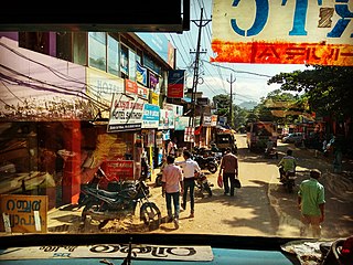
Vithura Town, also known as the Hill Town of Trivandrum, is located 36 km from Thiruvananthapuram capital of the Kerala state in India. Vithura is the culmination of the crossroads to many tourist, cultural, and religious centres. Surrounded by the Western Ghats (Sahyadris), Vithura is a prime tourist spot. The village is rich with a very scenic beauty and a good climate year-round. The Indian Institute of Science Education and Research, Thiruvananthapuram campus, one of the leading public science universities in the country, is situated here.

Kottayam, IPA: [koːʈːɐjɐm] is a city in the Indian state of Kerala. Flanked by the Western Ghats on the east and the Vembanad Lake and paddy fields of Kuttanad on the west, Kottayam is a place that is known for extraordinary qualities. It is the district headquarters of Kottayam district, located in south-west Kerala. Kottayam is located in the basin of the Meenachil River at an average elevation of 3 metres (9.8 ft) above sea level, and has a moderate climate. It is located approximately 155 kilometres (96 mi) north of the state capital Thiruvananthapuram. On 25 June 1989, Kottayam was declared as first '100% literate town' in India by Mr. N.P. Sahi.

Garudan Thookkamis a ritual art form performed in certain Kali temples in some Central Kerala districts in south India. The people who dress up as Garuda perform the dance. After the dance performance, the hang-designate dangle from a shaft hooking the skin on his back. In some places, the ritual is performed colorfully with Garudas taken in a procession on bullock carts or boats or hand pulled carts. It will be available in Devi temple during the festival of Meena bharani and Pathamudayam in Thiruvanchoor in Kottayam district.

Thalayolaparambu is a town situated in Kottayam district in Kerala, South India. Belonging to the Vaikom legislative assembly and Kottayam parliament constituency, it is one of the fastest growing chief towns situated in the Kottayam district.

Palampur is a hill station and a municipal corporation situated in the Kangra District in the Indian state of Himachal Pradesh. It is surrounded by pine forests and flanked by the Dhauladhar ranges. There are numerous streams flowing from the mountains to the plains from Palampur. The combination of greenery, snowclad mountains and water gives Palampur a distinctive look.
Ashta is a city and a municipality in Sehore district in the state of Madhya Pradesh, India. The nearest airport is in the city of Bhopal.
Kotdwar is a city, a municipal corporation and a tehsil in the Pauri Garhwal district of Uttarakhand, India. It's just 101 km from Pauri town, the district headquarter. It is the eighth-largest city in Uttrakhand. Its old name was "Khohdwar", which means the gateway of the river Khoh since it is located on the bank of river Khoh. It is situated in the southwestern part of the state and is one of the main entrance points in the state of Uttarakhand.

Kottiyoor is a village and Grama Panchayat situated in eastern hilly area of Kannur district in Kerala state. Kottiyoor is the 23rd Wildlife Sanctuary of Kerala, located in the serene hills of Western Ghats. The ancient pilgrimage conducted here yearly, called 'Kottiyoor Vysakha Mahotsavam' attracts thousands of devotees every year. The Vavali river flows through Kottiyoor.
Mannar is a census town in Chengannur Taluk in Alappuzha District of Kerala state, India, on State Highway 6. It is also known as the Bell Metal Town.

Aryankavu is a village located in the Kollam district of the South Indian state of Kerala. It lies close to the border between Kerala and Tamil Nadu near Thenmala. It is also one of the famous pilgrimage sites associated with the legend of Sabarimala. The village is located besides Shendurney Wildlife Sanctuary.
Chennithala is a census town in Mavelikkara taluk of Alappuzha district, Kerala state, India. This village consists mainly of paddy fields and coconut groves. Chennithala is a village where Hindus, Christians and Muslims live. There are many ancient Hindu temples. Christians of all denominations have their place of worship in Chennithala.

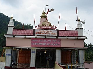
The Vaikom Mahadeva Temple is a temple for the Hindu god Shiva in Vaikom, Kerala, India. The temple, along with Ettumanoor Siva Temple, Kaduthuruthy Thaliyil Mahadeva Temple is considered a powerful trisome. The belief is that if a devotee worships at these three temples before 'Ucha pooja', all the wishes are fulfilled.
Kizhakkekallada, also known as East Kallada, is a large village in the Kollam district in the state of Kerala, India. It is located about 20 kilometres (12 mi) northeast of Kollam.

Vechoor is a village in Vaikom taluk, Kottayam district in the state of Kerala, India. Vechoor is a short drive away from one of Kerala's tourist destinations, Kumarakom. The Vechur Cow breed of cattle is named after this village.

The Jammu Division is a revenue and administrative division within Jammu and Kashmir, a union territory of India. It consists of the districts of Jammu, Doda, Kathua, Ramban, Reasi, Kishtwar, Poonch, Rajouri, Udhampur and Samba. Most of the land is hilly or mountainous, including the Pir Panjal Range which separates it from the Kashmir Valley and part of the Great Himalayas in the eastern districts of Doda and Kishtwar. Its principal river is the Chenab.
Kandorsona is a village in Burdwan II CD Block in Bardhaman Sadar North subdivision of Purba Bardhaman district of the Indian state of West Bengal, India.
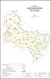
Sataon is a village and corresponding community development block in Rae Bareli district, Uttar Pradesh, India. It is located a bit to the west of the river Sai on the main Raebareli-Unnao road. It is 22 km from Raebareli, the district headquarters. As of 2011, its population is 9,151, in 1,756 households. It has 4 primary schools and 1 medical clinic.


