Val Chisone

Last updated
Val Chisone
Val Chisone0001.JPG
Val Chisone from Grand Puy (Pragelato)
Valchisoneposizione it.png
Location in the Piedmont region
Geography
Population centersPinerolo, Fenestrelle, Pragelato, Sestriere
Coordinates 45°0′N7°8′E / 45.000°N 7.133°E / 45.000; 7.133 Coordinates: 45°0′N7°8′E / 45.000°N 7.133°E / 45.000; 7.133
RiversChisone

The Val Chisone is one of the Occitan valleys of western Piedmont, situated in the Cottian Alps in the Metropolitan City of Turin in north-west Italy.

Contents

Geography

Traditionally, the valley's entrances are considered the towns of Pinerolo and Sestriere. It is bounded by the Val di Susa (to which it is connected by the Sestriere Pass, at 2,035 metres (6,677 ft)) to the north and east, the Val Sangone to the north, the Val Pellice to the south, while eastwards is the plain of the Po Valley.

The valley is crossed by the torrent from which it takes its name, the Chisone. The valley has a main branch, the Valle Germanasca, and a smaller branch in the area of Pragelato, Parco naturale Val Troncea, a nature park, an ideal destination for hikers, snowshoe hikers and cross-country skiers.

History

For centuries the Val Chisone was an object of contention between the Duchy of Savoy and the Kingdom of France. The upper valley (Val Pragelato) was part of the French Dauphiné, while the lower valley (Val Perosa) was under Savoyard control. In 1631, the right shore of the Val Perosa was ceded to Louis XIII of France, returning under Savoy by the Peace of Turin (1696).

The upper Val Chisone was part of the semi-independent French state of the Escartons Republic from 1343 to 1713. Pragelato was one of the five cantons. The Republic was annexed to Savoy in 1713.

The valley, together with Val Germanasca and Val Pellice, is home to a large Waldensian community.

Tourism

Hiking

The valley has a lot of hiking destinations. Some of the most important mountains are:

Punta Rognosa di Sestriere. Punta Rognosa di Sestriere.JPG
Punta Rognosa di Sestriere.

Winter Sports

Monte Motta, Sestriere. Sestriere MonteMotta.jpg
Monte Motta, Sestriere.

Val Chisone is renowned for winter sports: in 2006 several competitions within the XX Olympic Winter Games took place in Pinerolo, Pragelato and Sestriere.

Sestriere's huge skiing area hosted the alpine skiing. The area is part of the Via Lattea, a ski resort that comprises more than 163 skiing connected courses (41 blue, 92 red and 30 black slopes) and whose altitude ranges from 1,380 metres (4,530 ft) in Cesana to 2,800 metres (9,200 ft) on top of the Motta course. [1] The slopes in Sestriere also regularly host FIS Alpine Ski World Cup events.

Pragelato hosted cross-country skiing, nordic combined (cross-country skiing) and ski jumping. The ski jumping area was used in the later years for other competitions.

Pragelato offers 15 km (9 mi) of touristic cross-country pistes from approximately 1,530 to 1,750 metres (5,020 to 5,740 ft) above sea level. Besides the link with Via Lattea through cableway, the municipality has its own alpine ski courses (one chairlift and three platter lifts).

Pinerolo hosted curling.

Some huts are open in winter and are a destination for snowshoe hikers:

Related Research Articles

<span class="mw-page-title-main">Pinerolo</span> Comune in Piedmont, Italy

Pinerolo is a town and comune in the Metropolitan City of Turin, Piedmont, northwestern Italy, 10 kilometres (6.2 mi) southwest of Turin on the river Chisone. The Lemina torrent has its source at the boundary between Pinerolo and San Pietro Val di Lemina.

<span class="mw-page-title-main">Sestriere</span> Comune in Piedmont, Italy

Sestriere (/se'strjɛre/) is a ski resort in Piedmont, Italy, a comune (municipality) of the Metropolitan City of Turin. It is situated in Val Susa, 17 km (11 mi) from the French border. Its name derives from Latin: ad petram sistrariam, that is at sixty Roman miles from Turin.

<span class="mw-page-title-main">Pragelato</span> Comune in Piedmont, Italy

Pragelato is a comune (municipality) in the Metropolitan City of Turin in the Italian region Piedmont, located about 60 kilometres (37 mi) west of Turin, in the upper Val Chisone. The name Pragelato, meaning "icy meadow", has been derived from the harsh climate and the fact that the ground is covered with ice for long periods. On both sides of the Chisone, extensive forests of pine and larch provide protection from the avalanches which are a common occurrence in the winter season: for this reason in the nineteenth century the people of Pragelato were only permitted to fell trees close to the mountain summits, and even then only with the permission of the communal administration.

<span class="mw-page-title-main">Sauze d'Oulx</span> Comune in Piedmont, Italy

Sauze d'Oulx is a town and comune in the Metropolitan City of Turin, Piedmont located 80 km from Turin in the Val di Susa, at the foot of Monte Genevris.

<span class="mw-page-title-main">Geography of Piedmont</span>

The Geography of Piedmont is that of a territory predominantly mountainous, 43.3%, but with extensive areas of hills which represent 30.3% of the territory, and of plains (26.4%).

<span class="mw-page-title-main">3rd Alpini Regiment</span> Military unit

The 3rd Alpini Regiment is a regiment of the Italian Army's mountain infantry speciality, the Alpini, which distinguished itself in combat during World War I and World War II. The regiment is based in Pinerolo and assigned to the Alpine Brigade "Taurinense".

<span class="mw-page-title-main">Montgenèvre</span> Commune in Provence-Alpes-Côte dAzur, France

Montgenèvre is a commune on the Italian border in the Hautes-Alpes department in the Provence-Alpes-Côte d'Azur region in Southeastern France. In 2018, it had a population of 456.

<span class="mw-page-title-main">Chisone</span> River in Italy

The Chisone is a 53-kilometre (33 mi) Italian torrent, which runs through Pragelato, Fenestrelle, Perosa Argentina and Pinerolo in the Metropolitan City of Turin. It is a tributary of the Pellice, which in turn is a tributary of the river Po. Although classified as a torrent, there is no period of the year at which the Chisone runs dry.

<i>Grande Traversata delle Alpi</i>

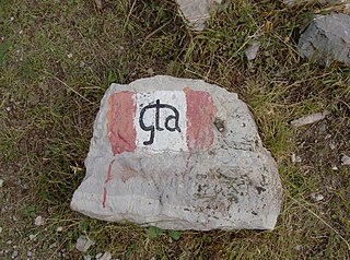
The Grande Traversata delle Alpi (GTA) is a long-distance hiking trail in the Italian region of Piedmont. In about 1,000 kilometres (620 mi) and 55 day hikes, it runs through the arc formed by the western Alps from the Pennine Alps through the Graian and Cottian Alps to the Maritime and Ligurian Alps. There are a number of transverse valleys along the route. Day hikes typically connect high-lying valley communities with each other via historic pass routes.

<span class="mw-page-title-main">Punta Sommeiller</span> Mountain in Italy

Punta Sommeiller or Pointe Sommeiller is a mountain of the Province of Turin, Italy and of Savoie, France. It lies in the Cottian Alps range. It has an elevation of 3,333 metres (10,935 ft) above sea level.

<span class="mw-page-title-main">Monte Orsiera</span> Mountain in Italy

Monte Orsiera is a mountain in the Cottian Alps belonging to the Province of Turin (Italy).

<span class="mw-page-title-main">Germanasca</span> River in Italy

The Germanasca is a 27 km (17 mi) Italian torrent, which runs through the Metropolitan City of Turin. It is a tributary of the Chisone, into which it flows near Perosa Argentina. The valley formed by the river is known as Val Germanasca.

<span class="mw-page-title-main">Garda Mountains</span> Northern Italian mountain range

The Garda Mountains, occasionally also the Garda Hills, are an extensive mountain range of the Southern Limestone Alps in northern Italy.

<span class="mw-page-title-main">Parco naturale Val Troncea</span>

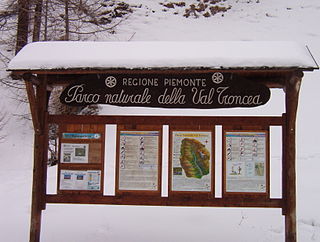
The nature park Parco naturale Val Troncea is located in Val Chisone, municipality of Pragelato in the Metropolitan City of Turin. The park was created in 1980 to preserve the natural environment.

<span class="mw-page-title-main">Bric Ghinivert</span> Mountain in Italy

Bric Ghinivert or Eiminàl is a mountain of the Cottian Alps located in Italy.

<span class="mw-page-title-main">Monte Politri</span> Mountain in Italy

Monte Politri or Bric Rosso is a 3,026 m a.s.l. mountain of the Cottian Alps, located in Italy.

<span class="mw-page-title-main">Monte Albergian</span> Mountain in Italy

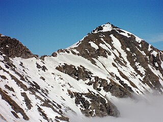
Monte Albergian is a 3,041 m a.s.l. mountain of the Cottian Alps, located in Italy. A battalion of 3rd Alpini Regiment, which during World War I earned a Silver Medal of Military Valor, was named after Monte Albergian.

<span class="mw-page-title-main">Pointe Rochers Charniers</span> Mountain in France

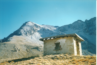
The Pointe Rochers Charniers is a mountain of the Cottian Alps at an elevation of 3,063 metres above sea level, located in France.

<span class="mw-page-title-main">Punta Cornour</span> Mountain in Italy

The Punta Cornour is a 2,868 metres high mountain on the Italian side of the Cottian Alps.

<span class="mw-page-title-main">Cima Ciantiplagna</span> Mountain in Italy

The Cima Ciantiplagna is a mountain in the Cottian Alps belonging to the Province of Turin (Italy).

References